
Texas Panhandle Storm Development Struggling Near Amarillo and Childress as Atmospheric Cap Suppresses Early Severe Weather
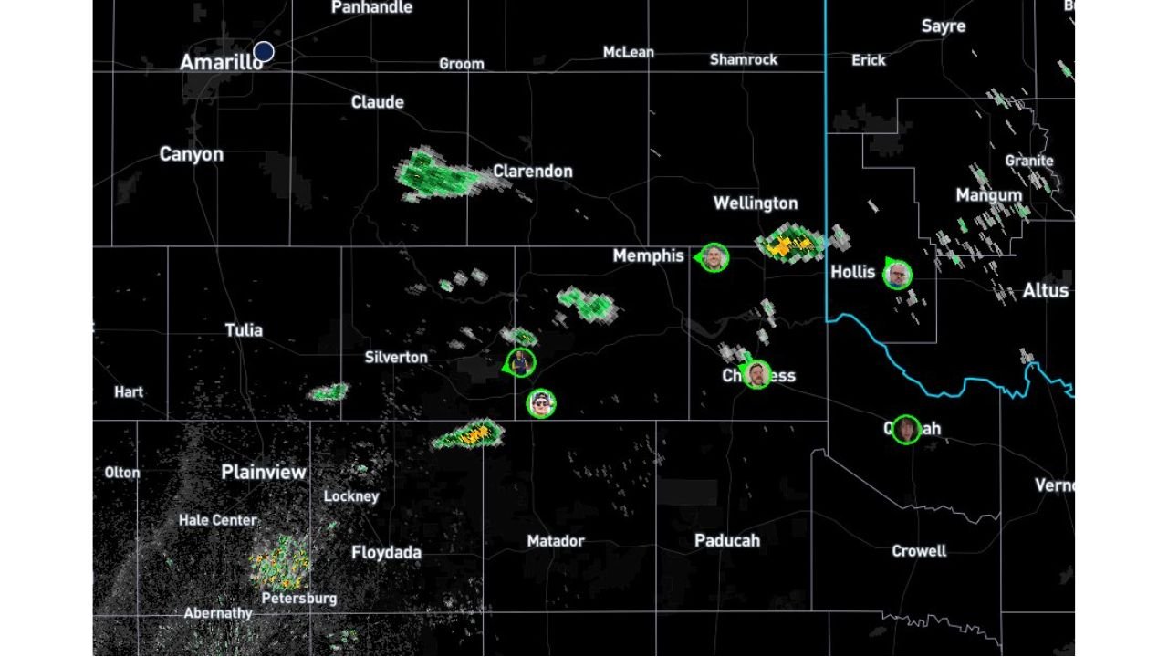
TEXAS PANHANDLE — Thunderstorm development across parts of the Texas Panhandle and western Oklahoma is currently struggling to intensify, as a stubborn atmospheric layer is preventing storms from growing tall enough to become severe. Radar observations show scattered storm “blips” forming near Amarillo, Clarendon, Memphis, and Childress, but forecasters say these storms are having difficulty strengthening due to a strong inversion layer in the atmosphere.
Meteorologists monitoring the situation say the storms are failing to push through a cap near the 700 millibar level, roughly 30,000 to 35,000 feet in the atmosphere. Without breaking through this layer, the storms cannot develop into the powerful thunderstorms needed to produce severe weather.
Atmospheric Cap Preventing Storms From Strengthening
The biggest obstacle to storm development right now is what meteorologists call an inversion or “cap” in the atmosphere.
This cap is acting like a lid, preventing rising air from continuing upward. As a result, the small thunderstorm towers currently forming across the region are struggling to grow wide and strong enough to break through that layer.
Radar imagery shows several isolated storm cells forming across the area, including locations near:
- Clarendon
- Memphis
- Childress
- Hollis, Oklahoma
- Areas south of Amarillo
However, many of these cells are quickly weakening as they drift north of a key atmospheric boundary that is helping fuel storm development.
Storms Moving Away From Favorable Environment
Another challenge for storm formation is that many of the developing cells are moving north of the boundary where atmospheric instability is strongest.
Once storms move north of this zone, the available energy needed for thunderstorm growth rapidly decreases, causing storms to weaken or dissipate.
Forecasters say this process is currently “killing off” several of the developing storm towers, preventing them from organizing into larger storm clusters.
Cold Front Forcing Still Positioned to the West
Meteorologists are closely watching a cold front located farther west, which may eventually provide stronger lifting forces needed to trigger more robust thunderstorm development later in the day.
At the moment, however, the front is not yet providing enough atmospheric lift to help these smaller storm cells break through the inversion layer.
Forecast models, including the HRRR high-resolution model, have been suggesting this exact scenario for several model runs, showing storms struggling early before potentially strengthening later if conditions improve.
Severe Weather Still Possible If Cap Breaks
Although storms are currently weak, meteorologists stress that the situation could change quickly if the cap weakens.
If storms are eventually able to break through the inversion layer, they could rapidly intensify into stronger thunderstorms capable of producing:
- Large hail
- Damaging winds
- Possible tornadoes
Because of this uncertainty, weather experts are continuing to monitor conditions closely across the Texas Panhandle and nearby areas of western Oklahoma.
Radar Monitoring Continues Across the Region
For now, radar continues to show scattered developing storms across the region, but most remain small and disorganized.
Communities including Amarillo, Clarendon, Memphis, and Childress are watching closely to see whether storms can strengthen later in the afternoon as atmospheric conditions evolve.
If stronger forcing from the approaching cold front arrives at the right time, forecasters say storm intensity could increase rapidly.
Stay with WaldronNews for continuing updates as meteorologists monitor developing storm conditions across the Texas Panhandle and southern Plains.