
Texas Severe Storm Threat Focuses on Three Key Zones as Forecasters Warn Tornado Risk and 3-Inch Hail Possible Near Oklahoma Border
TEXAS — Severe thunderstorms are expected to develop across Texas Thursday afternoon and evening, with meteorologists highlighting three primary storm zones stretching from the Texas Panhandle to southwest Texas. The most dangerous area appears to be near the Texas–Oklahoma border, where conditions may support tornadoes, destructive hail, and damaging winds.
Forecast guidance using high-resolution radar models suggests storms could intensify rapidly during the late afternoon and early evening hours, especially around 4 p.m. to 6 p.m., when atmospheric instability and wind shear reach their peak.
Northern Texas and Oklahoma Border Region Faces Highest Risk
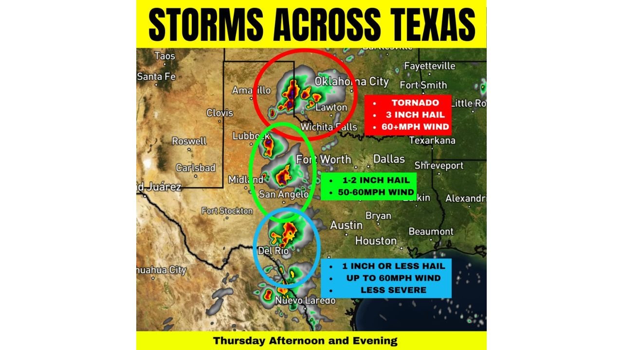
The most significant severe weather threat is expected across the Texas Panhandle and western Oklahoma, including areas near Amarillo, Lawton, Wichita Falls, and the Oklahoma City region.
This zone is expected to produce the strongest thunderstorms of the day, with hazards that may include:
- Tornado development
- Hail up to 3 inches in diameter
- Wind gusts exceeding 60 mph
Meteorologists say this region provides the best combination of storm instability and wind shear, allowing storms to rotate and potentially produce tornadoes if conditions align.
Cities near the Texas–Oklahoma border could see storms intensify quickly during the late afternoon hours as supercells begin to develop.
Central Texas Zone Could Produce Large Hail and Strong Winds
A second severe weather corridor is expected farther south across west-central Texas, including areas near Lubbock, Midland, San Angelo, and toward the Fort Worth region.
Storms in this zone may be slightly less organized than those near the Oklahoma border but could still produce significant severe weather.
Forecast hazards for this region include:
- 1 to 2 inch hail
- Wind gusts around 50 to 60 mph
- Isolated severe thunderstorms capable of localized damage
Because storms may remain somewhat scattered, the exact placement of the strongest cells could vary throughout the afternoon.
Southwest Texas Storms Likely Less Intense
The third area of interest extends into southwest Texas, including communities around Del Rio and areas toward the Mexico border.
Storms here are expected to be less organized overall, but forecasters say a few stronger cells could still develop as storms track northeast.
Possible impacts in this region include:
- Hail around one inch or smaller
- Wind gusts approaching 60 mph
- Brief periods of heavy rain and lightning
While the severe threat is lower compared to areas farther north, meteorologists say storms in this zone should still be monitored for isolated stronger cells.
Late Afternoon and Evening Storm Development Expected
Storm activity is expected to begin developing during the mid to late afternoon, with the most intense storms likely occurring during the evening hours as the atmosphere becomes increasingly unstable.
High-resolution forecast models indicate storms forming across western Texas may track northeast toward the Oklahoma border, where the environment becomes more supportive of rotating storms.
If supercells develop and remain isolated, the tornado threat could increase quickly during peak storm hours.
Residents Across Texas Urged to Stay Weather Aware
Because the storm setup could evolve rapidly, residents across the affected regions are encouraged to monitor weather updates closely throughout the afternoon and evening.
Safety recommendations include:
- Keeping weather alerts enabled on mobile devices
- Having a plan for shelter if tornado warnings are issued
- Avoiding travel during severe storms when possible
While not every area will experience severe weather, forecasters say any storm that strengthens could produce damaging conditions within a short period of time.
Stay with WaldronNews for continuing updates as severe storms develop across Texas and the southern Plains.