
Thunder and Lightning Break Out During Icing Event Across Northeast Texas as Winter Storm Shows Split Personality
NORTHEAST TEXAS — An unusual and dangerous winter weather setup unfolded overnight as thunder and lightning erupted during an ongoing icing event, confirming that this storm system is producing both cold-weather lightning and warm-sector lightning at the same time across the southern U.S.
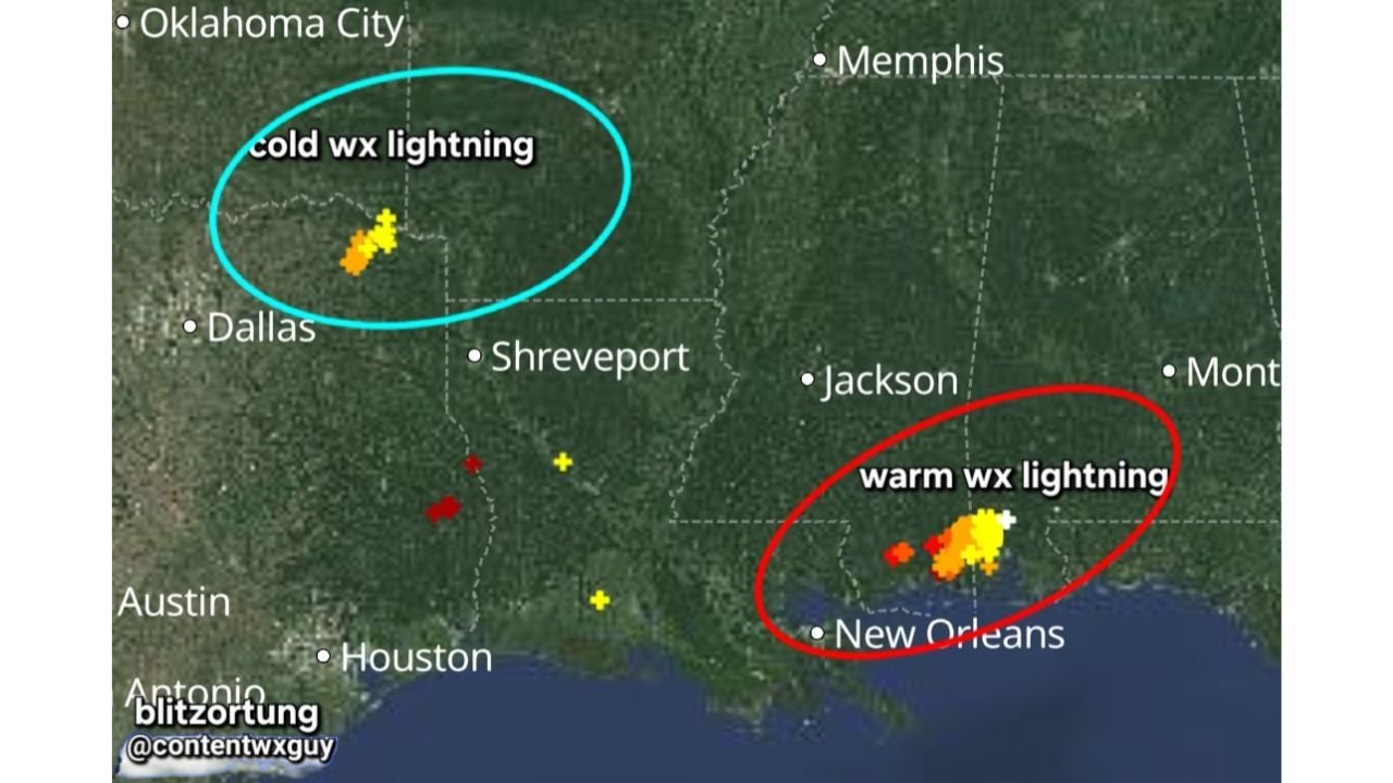
Radar and lightning data show thundersleet/thunderfreezing rain occurring in parts of northeast Texas near and east of the Dallas–Fort Worth region, while a separate zone of traditional warm-sector thunderstorms continues closer to the central Gulf Coast near southeast Louisiana. The split behavior highlights just how dynamic — and hazardous — this storm has become.
Cold-Weather Lightning Confirmed Over Northeast Texas
Lightning detections northwest and east of Dallas–Fort Worth are occurring entirely within sub-freezing surface temperatures, a clear sign of cold-weather convection embedded inside the winter storm. This type of lightning typically develops when strong lift forces ice crystals and graupel to collide inside deep winter clouds, generating electrical charge — even without surface warmth.
Key implications for northeast Texas:
- Active icing continues with freezing rain and sleet
- Thunder increases icing rates, causing faster ice accumulation
- Power outages and tree damage risks rise sharply
- Travel conditions can deteriorate rapidly with little warning
This is not a normal winter setup — lightning during freezing rain strongly suggests intense vertical motion, which often correlates with heavier ice accretion.
Warm-Sector Lightning Simultaneously Ongoing Near the Gulf Coast
At the same time, lightning clustered near southeast Louisiana and coastal Mississippi is occurring in a warm sector, where surface temperatures are above freezing and convection behaves more like a typical thunderstorm.
This contrast confirms the storm’s structure:
- Cold-sector lightning → northeast Texas / northwestern Louisiana
- Warm-sector lightning → Gulf Coast near New Orleans
The presence of both regimes simultaneously means the storm spans multiple atmospheric layers, increasing forecast uncertainty and impact severity.
Why This Setup Is Especially Dangerous
Thunder during icing events is rare — and often underestimated. When lightning appears in freezing rain:
- Ice accretion rates can spike suddenly
- Road conditions worsen faster than expected
- Power infrastructure is stressed by both ice load and wind
- Forecasts may lag real-time impacts
Residents may experience lulls followed by rapid deterioration, especially in northeast Texas counties east and southeast of DFW.
What Happens Next in Northeast Texas
As colder air continues pressing southward:
- Icing may transition to sleet or snow, but hazards will remain
- Lightning may fade, but accumulated ice damage will linger
- Travel disruptions and outages could persist well beyond precipitation ending
Officials urge residents to avoid travel, monitor power conditions, and prepare for extended cold impacts.
Stay with WaldronNews for continuous radar interpretation, winter storm impact analysis, and real-time updates as this highly unusual storm continues to evolve across northeast Texas and the southern U.S. Share local conditions to help keep your community informed.