
Today’s Tornado Threat Intensifies Across Arkansas, Missouri, Illinois and Indiana as High-Risk Corridor Takes Shape
UNITED STATES — A significant tornado setup is unfolding today across the Lower Mississippi Valley and into the Midwest, with forecast guidance highlighting a concentrated corridor of elevated tornado potential from Arkansas through southern Illinois and into Indiana.
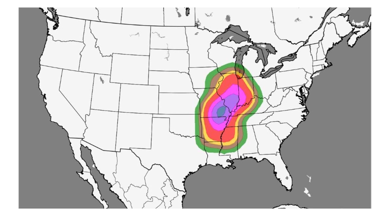
The latest Tornado PPH guidance shows the highest probability zone centered over central and eastern Arkansas, southeastern Missouri, western Tennessee, southern Illinois, western Kentucky, and parts of Indiana.
Core Tornado Risk: Arkansas Through Southern Illinois
The most concerning zone — marked by the highest probability shading — is focused near:
- Little Rock and Jonesboro, Arkansas
- Cape Girardeau, Missouri
- Paducah, Kentucky
- Evansville, Indiana
This corridor represents the strongest signal for tornadic development today if storms fully mature within the favorable environment.
Atmospheric ingredients across this region appear supportive of:
- Strong instability
- Enhanced wind shear
- Organized storm structures
These factors increase the risk for rotating thunderstorms capable of producing tornadoes.
Elevated Risk Expands Into Missouri and Indiana
Beyond the core, a broader zone of elevated tornado potential stretches into:
- Central Missouri
- Western and central Illinois
- Southern Indiana
- Northern Mississippi
- Western Tennessee
This indicates today’s severe weather setup is not isolated to one state but spans multiple regions across the central United States.
Communities across this wider zone should remain alert for watches and warnings as storms develop.
Southern Extension Into Mississippi and Louisiana
The tornado signal also extends southward into:
- Northern Mississippi
- Northeastern Louisiana
- Western Alabama
Storms developing in these areas could track northeast into the primary risk corridor later in the day.
Why Today Matters
Tornado PPH guidance reflects historical setups with similar atmospheric patterns. When a concentrated high-probability cluster appears like today’s, it suggests the environment resembles previous days that produced tornado activity in this region.
Mid-March is historically active for severe weather across the Mississippi Valley and Midwest, and today’s pattern aligns with that climatological peak.
What Residents Should Do
Residents across:
- Arkansas
- Missouri
- Illinois
- Indiana
- Kentucky
- Tennessee
- Mississippi
should monitor local forecasts closely and have multiple ways to receive warnings.
Storm timing and exact track details will determine where the highest impacts occur, but today’s setup supports a potentially active severe weather day.
WaldronNews.com will continue tracking this developing situation as storms begin to form and warnings are issued.