
Tornado and Lightning Threat Expands Across Kuwait, Eastern Saudi Arabia, Bahrain, Qatar and the United Arab Emirates on March 26
MIDDLE EAST — Severe weather potential is increasing across parts of the Middle East on Thursday, March 26, 2026, with forecast data indicating elevated tornado and lightning probabilities from eastern Saudi Arabia through Kuwait and into the Gulf states.
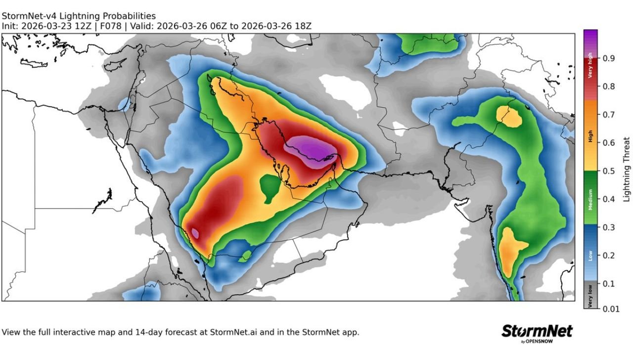
According to forecast guidance valid from 06Z to 18Z on March 26, the highest severe threat zone appears centered over Kuwait and adjacent eastern Saudi Arabia, with impacts potentially extending into Bahrain, Qatar and the United Arab Emirates.
Tornado Probabilities Focused Near Kuwait and Eastern Saudi Arabia
Forecast tornado probability maps show a concentrated corridor of elevated risk stretching:
- Across central and eastern Saudi Arabia
- Into Kuwait
- Westward toward the northern Persian Gulf region
The strongest probabilities appear clustered near the Kuwait–Saudi Arabia border region, where atmospheric conditions may support rotating storms if sufficient instability develops.
A secondary, smaller area of lower tornado probability is also visible farther southwest over parts of western Saudi Arabia.
Lightning Threat More Widespread
Lightning probability guidance paints an even broader picture. The highest lightning risk covers:
- Eastern and central Saudi Arabia
- Kuwait
- Portions of Bahrain
- Areas of Qatar
- Western sections of the United Arab Emirates
The core of the lightning threat aligns with the same zone highlighted for tornado potential, indicating strong thunderstorm development is likely within that corridor.
Additional lightning activity is projected across parts of Oman and eastern portions of the Arabian Peninsula.
What This Means for the Region
While tornadoes are relatively uncommon in much of the Middle East compared to parts of the United States, they are not unheard of — particularly when strong convective systems develop under favorable wind shear conditions.
The overlapping signals of enhanced tornado and lightning probabilities suggest:
- Strong thunderstorms capable of intense lightning
- Possible localized damaging wind gusts
- Potential for rotating storm structures in isolated areas
The most concentrated threat window appears during the late morning through afternoon hours (06Z–18Z), depending on storm evolution.
Multiple Severe Weather Signals at Once
The forecast setup reflects a dynamic atmospheric pattern, with instability and wind energy aligning across the northern Gulf region. The overlapping zones of elevated tornado and lightning potential indicate organized storm clusters rather than isolated, weak cells.
Residents in Kuwait, eastern Saudi Arabia and neighboring Gulf states should monitor local weather advisories and be prepared for rapidly changing conditions.
For ongoing international severe weather coverage, stay with WaldronNews.com.