
Tornado Threat Increasing Thursday From Amarillo, Texas to Altus, Oklahoma as Evening Supercells May Produce Hail and 60+ MPH Winds
TEXAS PANHANDLE & SOUTHWEST OKLAHOMA — Weather conditions across parts of the Texas Panhandle and western Oklahoma are expected to become increasingly favorable for severe thunderstorms and potential tornado development on Thursday, March 5, particularly from Amarillo to Altus. Meteorologists are highlighting a corridor that includes communities such as Claude, Silverton, Floydada, Turkey, Matador, Memphis, Childress, Hollis, and Quanah where the tornado risk may rise later in the day.
Forecast data indicates that a combination of shifting winds, temperature contrasts, and a developing boundary in the atmosphere could allow thunderstorms to organize into rotating supercells capable of producing tornadoes, especially during the evening hours.
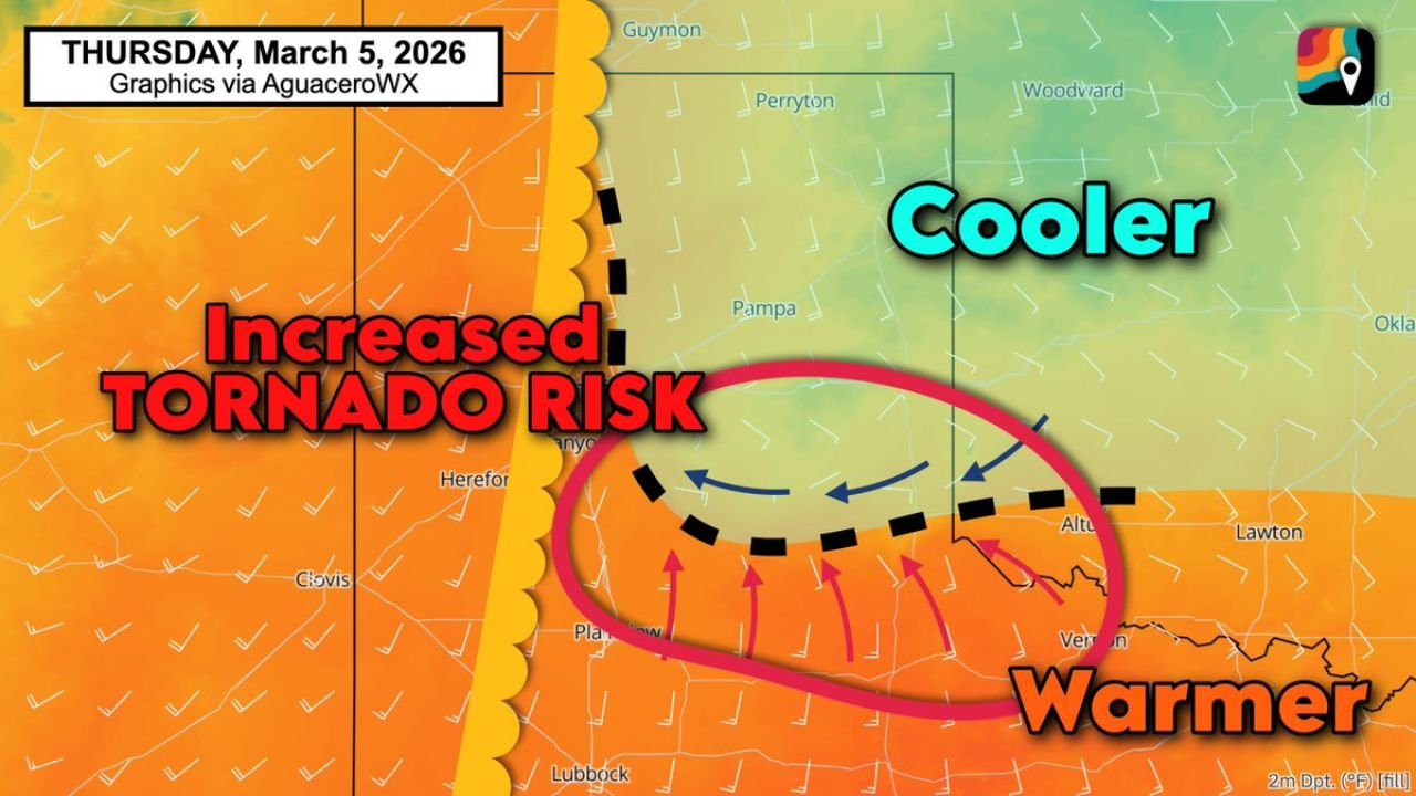
Cooler Air From Oklahoma Storms Could Help Trigger Tornado Potential
According to the forecast setup, storms developing Thursday morning across Oklahoma are expected to push cooler air southward as they move through the region. Meteorologists often refer to this phenomenon as “thunderstorm outflow,” where storm systems release cooler air that spreads outward across nearby areas.
The leading edge of this cooler air could settle near Highway 287, forming a boundary between cooler air to the north and warmer air to the south. Areas south of this boundary will remain warm and unstable, creating an environment that can help fuel strong thunderstorms later in the day.
This temperature contrast is important because boundaries like these often become prime locations for storm development, especially when warm, moist air collides with cooler air masses.
Outflow Boundary May Increase Low-Level Spin in the Atmosphere
Meteorologists say the key concern lies along the outflow boundary, where wind patterns are expected to shift direction. When winds change direction and speed at different heights in the atmosphere, it creates helicity, or low-level spin.
Helicity is a crucial ingredient in severe weather forecasting because it can allow thunderstorms to develop rotating updrafts. When storms latch onto these zones of enhanced spin, they can intensify rapidly and potentially produce tornadoes.
In this situation, any supercell thunderstorms forming along the dryline could move into the boundary and absorb this added spin. As the rotating air stretches vertically inside the storm, the tornado risk increases.
Forecasters note that this process could become particularly significant during the evening hours between 6 p.m. and 10 p.m., when atmospheric conditions may be most favorable for storm intensification.
Texas Panhandle and Western Oklahoma in the Primary Risk Zone
The area most likely to experience these conditions stretches across a corridor of the Texas Panhandle into southwest Oklahoma. Cities and towns near this zone include:
- Amarillo, TX
- Claude, TX
- Silverton, TX
- Floydada, TX
- Turkey, TX
- Matador, TX
- Memphis, TX
- Childress, TX
- Quanah, TX
- Hollis, OK
- Altus, OK
These locations sit close to the forecast boundary where the clash between warm and cooler air could help storms organize.
Large Hail and Damaging Winds Also Possible
Even if tornadoes do not develop in every storm, the atmospheric environment could still support severe weather hazards.
Forecasters warn that storms forming in this region could produce:
- Tennis ball–sized hail
- Wind gusts exceeding 60 mph
- Intense lightning and heavy rainfall
- Isolated tornadoes in stronger supercells
Large hail is often a sign of strong updrafts inside thunderstorms, which can keep hailstones suspended long enough to grow significantly before falling to the ground.
Meanwhile, powerful downdrafts could generate damaging straight-line winds, capable of downing trees, damaging roofs, and causing power outages.
Evening Hours Could Be the Most Active Period
While storms may begin forming earlier in the day, meteorologists say the highest tornado risk window appears to be between 6 p.m. and 10 p.m. Thursday.
During this period, the combination of warm air near the surface, cooler air pushing south, and strengthening winds aloft could create the most favorable environment for rotating thunderstorms.
Residents across the Texas Panhandle and southwest Oklahoma are encouraged to stay weather-aware Thursday evening, monitor local forecasts, and have multiple ways to receive severe weather warnings.
Stay Updated With WaldronNews
Severe weather setups like this can change quickly as new data becomes available. WaldronNews will continue monitoring updates on the evolving storm threat across Texas and Oklahoma.
Stay connected with WaldronNews.com for the latest weather alerts, forecast updates, and safety information as this severe weather system develops.