
Toronto, Hamilton and London Ontario Face Tornadoes, 112 km/h Winds and Large Hail Tuesday as QLCS Storm System Targets Southern Ontario
TORONTO, ONTARIO — A fast-moving and dangerous squall line storm system is forecast to sweep through Southern Ontario Tuesday afternoon and evening, bringing the potential for tornadoes, damaging winds up to 112 km/h and large hail up to 2.5 centimeters to communities across the region — including Toronto, Hamilton, London and the broader Greater Toronto Area. Weather models have been increasing in consistency about the threat, revealing that a QLCS-style storm event — a quasi-linear convective system, which is essentially an organized and intense line of thunderstorms — may move through Southern Ontario Tuesday, though the exact location of the most intense activity is still being resolved as models continue to fine-tune small-scale features in the forecast.
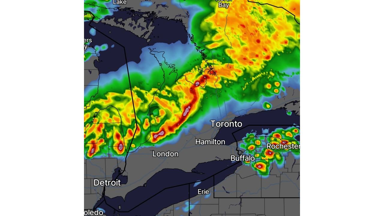
The radar simulation shows an intense line of storm activity stretching from the London and Detroit corridor northeastward through the Toronto and Hamilton area toward North Bay — with the heaviest and most dangerous storm cells shown in deep red and orange on the forecast imagery.
Cities and Areas at Risk Tuesday in Southern Ontario
The storm threat covers a significant portion of Southern Ontario (SONT) Tuesday afternoon and evening:
Primary risk zone:
- Toronto — directly in the path of the forecast QLCS storm line
- Hamilton — southwest of Toronto, in the core of the storm corridor
- London, Ontario — western anchor of the storm track, where initial storm development is possible
- Greater Toronto Area — Mississauga, Brampton, Oakville and surrounding communities all within the potential impact zone
- North Bay corridor — northeastern extent of the storm system
Secondary and fringe areas:
- Windsor and the Detroit border corridor — western fringe of the storm threat
- Barrie and Georgian Bay communities — northern fringe as the system tracks northeastward
- Kitchener-Waterloo — within the broader risk corridor between London and Toronto
Primary Threats Tuesday for Southern Ontario
Forecasters are highlighting three specific hazards for Tuesday’s storm event across Southern Ontario:
- Tornadoes — a few tornadoes are possible as the QLCS tracks through the region. QLCS tornadoes are particularly dangerous because they can form quickly and with very little warning time — sometimes only a few minutes between when a tornado warning is issued and when the tornado touches down
- Damaging winds up to 112 km/h — widespread damaging wind gusts along and behind the storm line are possible across the entire Southern Ontario corridor from London through Toronto and Hamilton. At 112 km/h, these winds are capable of downing trees, snapping power lines and causing significant property damage across a wide area
- Large hail up to 2.5 cm — hail the size of a large marble is possible, particularly in stronger storm cells ahead of or embedded within the main squall line. This size of hail can crack windshields, damage vehicles and injure people caught outside
Why the Exact Location Is Still Uncertain
Forecasters are being transparent about the fact that the exact location of the most intense storm activity within Southern Ontario is still uncertain. This is a normal and honest caveat for a QLCS event at the one-day range — small differences in where the storm line tracks can shift the worst impacts by 50 to 100 kilometers. The difference between Toronto being in the core of the storm versus Hamilton or London taking the brunt of the activity comes down to subtle features in the atmosphere that models are still working to resolve.
What is not uncertain is that a significant severe weather event is coming to Southern Ontario Tuesday. Whether your specific community ends up in the worst zone or just catches the edges of the system, the potential for dangerous weather exists across the entire London to Toronto to Hamilton corridor and beyond.
The QLCS Tornado Threat — What Southern Ontario Residents Need to Know
The tornado threat in a QLCS event like Tuesday’s is different from the tornado threat in a classic isolated supercell. With supercells, forecasters often have 20 to 30 minutes or more of warning before a tornado touches down. With QLCS tornadoes, the warning time is often much shorter — sometimes 5 minutes or less — because the tornadoes form within a fast-moving storm line rather than from a slowly rotating supercell.
This means that residents across Toronto, Hamilton and London should not wait for a tornado warning to take shelter on Tuesday. If a severe thunderstorm warning or tornado watch is issued for your area, move to your shelter location immediately — a basement, interior room on the lowest floor of a sturdy building, or a storm shelter. Do not wait to see or hear the storm before acting.
Multi-Day Pattern: More Active Weather Follows
Tuesday’s severe weather event in Southern Ontario is part of the same active weather pattern that is producing severe storms across the United States Midwest and Plains this week. The storm system that affects Toronto, Hamilton and London on Tuesday is connected to the same large-scale atmospheric setup bringing threats to Michigan, Ohio and Indiana. Residents across Southern Ontario should be aware that the active weather pattern may not end with Tuesday — monitor forecasts through the rest of the week.
What to Watch Next
- Tuesday afternoon storm initiation — whether the QLCS fires on schedule across the London corridor and tracks northeastward toward Toronto and Hamilton
- Environment Canada warnings — watch for tornado watches and severe thunderstorm warnings to be issued for Southern Ontario communities Tuesday afternoon
- Model updates through Tuesday morning — the exact storm track should become much clearer as Tuesday approaches and model guidance converges
- Toronto commute timing — whether the storm system arrives during peak afternoon commute hours or later in the evening
- Power outage potential — 112 km/h wind gusts across a densely populated region like Greater Toronto could cause widespread outages
Residents across Toronto, Hamilton, London and the Greater Toronto Area should have a severe weather plan ready before Tuesday afternoon, keep weather alerts enabled on mobile devices and know where they will shelter if a tornado warning is issued.
WaldronNews.com will continue tracking Tuesday’s severe weather threat across Southern Ontario and provide updates on watches, warnings and storm timing as the event approaches.