
Toronto, Hamilton, Kitchener and London Ontario Face Flash Flooding and Toonie Sized Hail Tonight as Training Thunderstorms Bring 50mm Per Hour Rainfall With Stronger Storms Expected Tuesday
TORONTO, ONTARIO — It is going to be a noisy and dangerous night across Southwestern Ontario and the Golden Horseshoe. Environment Canada has issued a severe thunderstorm watch covering a large swath of the region — including Toronto, Hamilton, Kitchener, London, Barrie, Owen Sound and Newmarket — with the potential for toonie-sized hail and flash flooding as thunderstorms develop and track through the area overnight into the early hours of Tuesday morning.
The biggest concern tonight is not the individual storms themselves — it is training thunderstorms, where repeated rounds of intense thunderstorms move over the same area for hours on end, stacking up rainfall totals that drain systems cannot handle and turning streets into rivers. Rainfall rates could easily reach 50 millimeters per hour in the strongest storm cells — and if that continues for even two to three hours over the same community, the flooding potential becomes serious very quickly.
And this is only round one. Tuesday afternoon and evening looks worse.
Areas Under the Severe Thunderstorm Watch Tonight
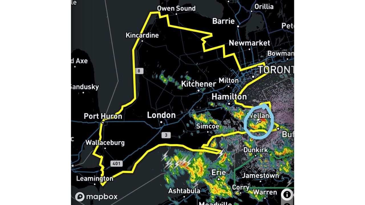
The Environment Canada severe thunderstorm watch zone — shown as the yellow boundary on the radar map — covers a massive portion of Southern Ontario including:
- Toronto and the Greater Toronto Area — Mississauga, Brampton, Vaughan, Markham, Newmarket, Milton
- Hamilton — directly in the training storm corridor tonight
- Kitchener and Waterloo — within the watch zone for both flooding and hail
- London, Ontario — southwestern anchor of the watch zone
- Barrie and Owen Sound — northern extent of the warning area
- Kincardine and the Lake Huron shoreline — western watch boundary
- Welland and the Niagara region — a storm cell is currently tracking through this area with small hail already being reported
- Simcoe and Leamington — southern portions of the watch zone near Lake Erie
What Is Happening Right Now and What Comes Next
Right now — a storm cell is tracking through the Niagara and Welland region, circled in blue on the radar, and is producing small hail. Residents in the Welland, Niagara Falls and St. Catharines area should be aware of ongoing activity.
Around midnight — a cluster of thunderstorms is expected to develop over Michigan and Lake Huron, then track eastward through areas east of Lake Huron and into the Greater Toronto Area. These storms could linger through the early morning hours of Tuesday.
The primary concern with the overnight storms is training — where multiple rounds of storms follow the same path over communities like Toronto, Hamilton and Kitchener, dropping rainfall so rapidly that storm drains overflow, underpasses flood and low-lying streets become impassable. Urban environments are particularly vulnerable to this type of rainfall because concrete and pavement cannot absorb water the way open ground does.
Hail Threat Tonight — Up to Toonie Size
Environment Canada’s severe thunderstorm watch specifically mentions toonie-sized hail as a possibility in the strongest storm cells tonight. A toonie — the Canadian two-dollar coin — is approximately 28 millimeters in diameter, which is large enough to cause significant damage to vehicles, crack windows, damage roofs and injure anyone caught outside without shelter.
This hail threat is described as similar to a storm earlier this month when golf ball sized hail was reported near Hopeville — a reference that local residents will recognize as a particularly damaging event. The atmospheric dynamics tonight are favorable for the same type of large hail development in the strongest cells.
Why Tonight Is Just the Warm-Up
As dangerous as tonight’s storm threat is for Toronto, Hamilton and the Golden Horseshoe, forecasters are already warning that Tuesday afternoon and evening looks worse. The overnight round is part of the leading edge of a broader and more organized severe weather system — and Tuesday’s storms are expected to be stronger, more organized and potentially more widespread than what overnight brings.
Residents across Southwestern Ontario should treat tonight seriously — but also prepare for Tuesday to be the more significant severe weather day for the region. This is a two-round event and the second round is expected to be the harder punch.
Primary Threats Tonight for Southern Ontario
- Flash flooding — the number one concern. Training thunderstorms with 50+ mm per hour rainfall rates could cause rapid and dangerous flooding in Toronto, Hamilton, Kitchener and London overnight
- Toonie-sized hail — possible in the strongest cells, capable of damaging vehicles and property
- Damaging winds — embedded within strong storm cells moving through the watch zone
- Overnight timing — storms arriving after midnight mean many residents will be asleep when the worst activity occurs. Weather alerts must be enabled on mobile devices
What to Watch Next
- Midnight storm cluster developing over Michigan and Lake Huron — tracking toward the Greater Toronto Area
- Welland and Niagara — current storm cell producing hail, watch for updates
- Flash flood reports across Toronto, Hamilton and Kitchener during the overnight hours
- Tuesday afternoon severe weather setup — expected to be stronger than tonight’s event across Southern Ontario
- Environment Canada watches and warnings — monitor for possible upgrades to severe thunderstorm warnings as storms develop overnight
Residents across Toronto, Hamilton, Kitchener, London, Barrie and the Golden Horseshoe should move vehicles to higher ground if possible, avoid driving through flooded roadways overnight and ensure weather alert notifications are active on all mobile devices before going to sleep.
WaldronNews.com will continue monitoring tonight’s severe weather threat across Southern Ontario and will provide updates on flooding, hail reports and storm timing through the overnight hours and into Tuesday’s more significant weather event.