
Two Snowstorm Scenarios Emerge for Mid-Atlantic and Southern New England: Offshore Coastal Hit or Major Blizzard From Maryland to Massachusetts
MID-ATLANTIC AND SOUTHERN NEW ENGLAND — With roughly 48 hours until the expected start of a significant winter storm, forecast guidance has narrowed into two primary scenarios — and both would bring impactful snow to parts of the Mid-Atlantic and Southern New England. The key question now is not whether someone sees heavy snow, but exactly who ends up in the bullseye.
Major global models remain split. The European model suite (Euro/Euro AI/CMC) favors Scenario 1, while the GFS and NAM lean toward Scenario 2. Each solution presents very different impact zones from Pennsylvania and New Jersey to New York and Massachusetts.
Scenario 1: Slightly Weaker, More Offshore Track — Mainly a Coastal Event
In the first scenario, the storm remains slightly weaker and tracks farther offshore. Under this setup:
- Heavy snow is largely confined to coastal sections of New Jersey, eastern Long Island, and southeastern Massachusetts.
- Moderate snow extends inland across parts of eastern Pennsylvania, northern New Jersey, southern New York, and coastal Connecticut.
- Light snow reaches farther inland into central Pennsylvania, upstate New York, and interior New England.
This outcome would produce a classic coastal-focused event, where areas along and east of the I-95 corridor see the most significant accumulations, while inland regions experience lighter totals.
Major cities like New York City, Boston, and possibly coastal New Jersey communities would still see impactful snowfall, but interior zones west of the coastal plain would be spared the worst.
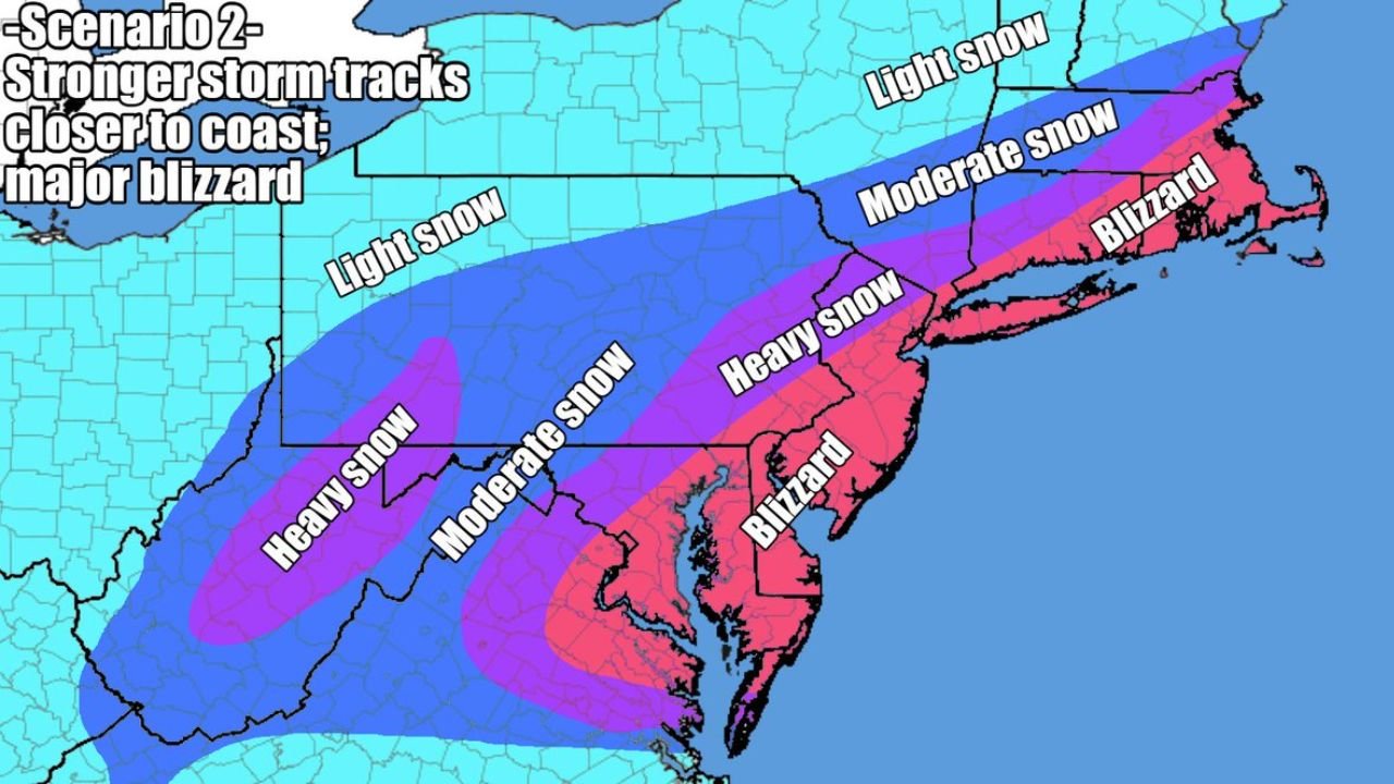
Scenario 2: Stronger Storm, Closer Track — Major Blizzard Potential
The second scenario shows a stronger coastal low tracking closer to the shoreline. This dramatically increases impacts across a much broader region.
Under this solution:
- Blizzard conditions develop across parts of Maryland, Delaware, New Jersey, eastern Pennsylvania, Long Island, and southeastern New York, extending into portions of Connecticut and Massachusetts.
- A wide swath of heavy snow stretches inland from western Pennsylvania through northern New Jersey and into southern New England.
- Even areas farther west see moderate accumulations, expanding the footprint of disruptive snowfall.
In this scenario, cities including Philadelphia, New York City, Newark, Baltimore, and Boston could face not just heavy snowfall but also strong winds capable of producing blowing snow and whiteout conditions.
Who Is Most at Risk?
Both scenarios indicate that someone across the Mid-Atlantic and Southern New England will see impactful snow. The dividing line between moderate and heavy snow currently appears to run across:
- Eastern Pennsylvania
- Northern and central New Jersey
- Southern New York State
- Coastal Connecticut and Rhode Island
- Massachusetts
Even a 50–75 mile shift in storm track could move the heavy snow axis dramatically north or south.
Timing and Impact Window
The storm is expected to develop late weekend into early next week, with the most significant impacts likely occurring from Sunday into Monday.
Key factors that will determine the final outcome include:
- Strength and consolidation of the coastal low
- Interaction with upper-level energy
- Placement of mesoscale snow bands
- Wind intensity along the coastal plain
If Scenario 2 verifies, parts of the Mid-Atlantic and Southern New England could be dealing with a full-fledged blizzard. If Scenario 1 prevails, impacts remain significant but are more narrowly focused along the immediate coast.
Final Take
At this stage, confidence is high that a meaningful snow event is coming for portions of Pennsylvania, New Jersey, New York, and New England. What remains uncertain is the exact placement of the heaviest snow and whether the storm intensifies enough to produce blizzard conditions.
Residents across the region should closely monitor forecast updates over the next 24–36 hours, as small shifts in track will determine who ends up digging out from a heavy snowfall — and who avoids the worst.
Stay with Waldronnews.com for continuing coverage as this high-stakes winter forecast comes into focus.