
Two-Week Precipitation Deficits Expand Across Kansas, Missouri, Illinois, Ohio, and Pennsylvania as U.S. Shifts Toward Early Spring Pattern
UNITED STATES — New National Weather Service precipitation anomaly data shows a widespread and significant drying trend across much of the central and eastern United States, reinforcing signals that the broader weather pattern is transitioning away from mid-winter and toward an early spring regime.
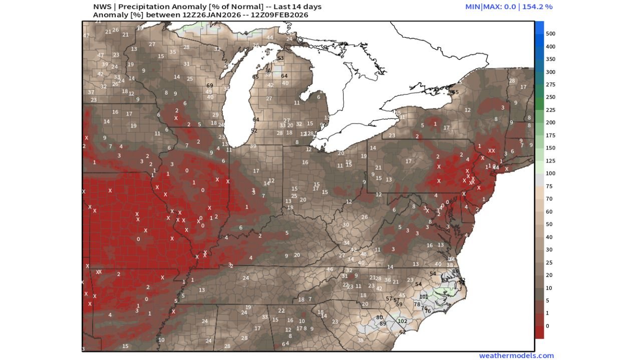
The map, covering the last 14 days from January 26 through February 9, highlights large areas receiving well below normal precipitation, with some regions registering near-zero percent of average rainfall or snowfall.
Deep Deficits Dominate the Central Plains and Midwest
The most pronounced precipitation shortfall is centered across the Central Plains into the Mid-Mississippi Valley, where expansive red shading indicates extreme dryness.
Parts of:
- Kansas
- Missouri
- Arkansas
- Oklahoma
- Illinois
have seen single-digit or near-zero precipitation percentages, confirming a prolonged stretch with little to no meaningful storm activity.
This dryness reflects a storm track repeatedly displaced north and east, leaving the interior central U.S. largely untouched.
Ohio Valley and Interior Northeast Also Running Well Below Normal
Dry conditions extend eastward into the Ohio Valley, western Pennsylvania, and interior sections of the Northeast, where precipitation totals remain well under seasonal averages.
Although not as extreme as the Plains, much of:
- Indiana
- Ohio
- Western Pennsylvania
- Upstate New York
has experienced persistent precipitation deficits, consistent with a flatter, faster-moving jet stream that limits storm organization.
Southeast and Coastal Carolinas Stand Out as Exceptions
In contrast, parts of the Southeast — especially the Carolinas and coastal Georgia — show near-normal to above-normal precipitation.
Localized areas along the southern Atlantic coast recorded 70–100% or higher of normal rainfall, likely tied to:
- Occasional coastal systems
- Moisture-rich southern stream disturbances
However, these wetter pockets remain isolated compared to the broader dryness dominating inland areas.
Pattern Reflects Seasonal Transition, Not Storm Failure
The data strongly suggests the dryness is pattern-driven, not random. As winter wanes:
- Storm systems become faster and less amplified
- Cold air supply weakens
- Precipitation becomes more scattered
This aligns with the observation that the U.S. is effectively entering a spring-leaning atmospheric setup, where long dry stretches are more common between systems.
Implications Going Forward
If this trend persists:
- Snowpack growth will stall in many interior regions
- Soil moisture could decline ahead of spring planting
- Winter storm opportunities may become more conditional and localized
While individual storms can still occur, the overall background pattern favors reduced coverage and efficiency.
Bottom Line
The last two weeks of precipitation data paints a clear picture: much of the central and eastern United States is drying out, a hallmark signal that winter’s grip is loosening.
As February progresses, this pattern supports a gradual seasonal transition, with fewer widespread precipitation events and a growing reliance on isolated systems to bring meaningful moisture.
WaldronNews.com will continue tracking how this drying trend evolves as spring approaches.