
U.S. Weather Pattern Set for Dramatic Flip as Brutal Cold Eases and Major Warm-Up Targets Texas, California and the Plains
DALLAS, TEXAS – After nearly three straight weeks of bitter cold dominating much of the United States, a dramatic shift is poised to unfold. New European Ensemble teleconnection maps show a major warm-up developing 11–15 days from now, with the cold pattern “ripping” first — then flipping — as temperatures soar across the West, Plains, and South.
The shift is tied to a significant positive phase change in the Eastern Pacific Oscillation (EPO), a climate index known for controlling how much Arctic air can pour into the U.S. When the EPO spikes positive after a long negative stretch, cold air retreats and warmer Pacific air floods the country.
That is exactly what the models now show.
Three Weeks of Cold About to End — But Not Quietly
For weeks, the first half of December has delivered blow after blow of Arctic air across the Great Lakes, Midwest, and Northeast. Some locations ran 20–30 degrees below normal, triggering lake-effect snow bursts and dangerous wind chills.
But climate forecasters now point out that the EPO — which previously supported strong cold — has swung sharply positive. This typically marks the collapse of sustained Arctic outbreaks across the lower 48.
One atmospheric analyst summed it up:
“When the EPO flips, the pattern flips. The cold gets ripped out and warmth floods in.”
The timing aligns closely with long-range discussions shared in energy-sector forecasts for the 12/5, 12/12, and 12/19 weekly outlooks.
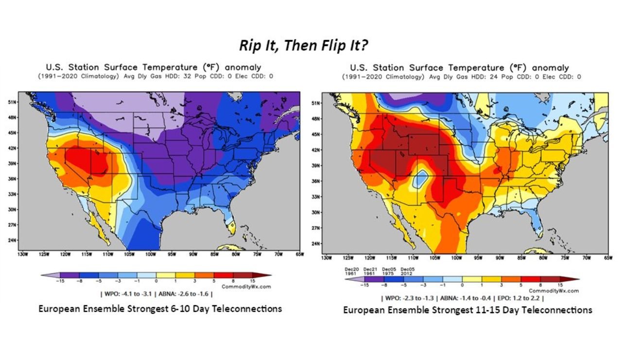
6–10 Day Outlook: Cold Still Dominates East While West Turns Mild
The first half of the transition still looks chilly, especially across the Midwest, Great Lakes, New York, Pennsylvania, and New England.
European model maps for days 6–10 show:
- Deep blues across the East and Midwest
- Below-normal temperatures holding on
- Warmth beginning to build across California, Nevada, Utah, Arizona, and New Mexico
This pattern marks the final phase of the persistent cold train — the “rip it” portion referenced in the graphic.
Meanwhile, the West is already seeing strong warming signals, with anomalies 5–15°F above normal on the western ridges.
11–15 Day Outlook: Warmth Explodes Across the Country
Here is where the flip occurs.
By days 11–15, the European Ensemble shows:
- A massive surge of warmth expanding across Texas, Oklahoma, Kansas, Nebraska, Colorado, New Mexico, Arizona, and California
- A warm ridge pushing east toward the Mississippi Valley
- Above-normal temperatures for most of the South, West, and central U.S.
- Only a small pocket of lingering cool air in far northern New England
This is a classic EPO-driven warm intrusion — a flood of Pacific air overwhelming the Arctic pattern that ruled early December.
Meteorologists studying the teleconnections note similarities to warm-ups documented in 1961, 1975, and 2012 according to ensemble composites referenced in energy market research.
A weather strategist even remarked:
“This flip is aggressive. Models don’t just hint at warmth — they slam the map with it.”
What the Pattern Means for Everyday Americans
Central & Southern U.S. (Texas, Oklahoma, Kansas, Arkansas)
Expect afternoon highs well above normal. Outdoor work, travel, and holiday events will feel more like early November than mid-December.
West Coast (California, Nevada, Arizona)
Significant warm anomalies appear likely, raising concerns about lagging early-season snowpack. Ski areas may struggle to retain low-elevation snow.
Midwest & Northeast
Cold hangs on a bit longer but fades quickly after day 10. The flip may reduce snow chances and soften heating demand.
Energy Sector Impacts
A warm-up like this can reduce natural gas demand and shift price forecasts — a trend frequently highlighted in commodity outlooks tied to atmospheric teleconnections.
Why This Flip Is So Important for Winter Forecasting
Meteorologists often track the EPO because it can abruptly end or extend winter cold. A positive EPO opens the door for milder Pacific air, reversing the jet-stream pattern that previously funneled Arctic highs into the U.S.
In seasonal discussions shared by long-range forecasters, a strong positive EPO like this often leads to:
- Decreased snowstorm activity
- Shorter cold snaps
- Temporary mid-month thaws
- A broader shift toward zonal flow
This pattern does not mean winter is over — but it does signal a major pause.
Are you ready for a warm-up after nearly three straight weeks of Arctic air? Do you think this flip means fewer snow chances for your area?
Share your thoughts and join the conversation at Waldronnews.com.