
Uncertain Winter Storm to Impact Pennsylvania With Heavy Snow North and Sleet Risk in Northeastern Counties
PENNSYLVANIA — A complex winter storm is expected to move through the state late Friday into Saturday, with heavy, plowable snow favored across northern and central Pennsylvania, while areas farther south — especially parts of Northeastern Pennsylvania — face a difficult snow-versus-sleet forecast that could dramatically change impacts from town to town.
Meteorologists say confidence is high that locations north of the primary transition zone will see mostly snow, but just a short distance south, precipitation type could fluctuate rapidly due to subtle temperature differences in the atmosphere.
Heavy Snow Favored in Northern and Central Pennsylvania
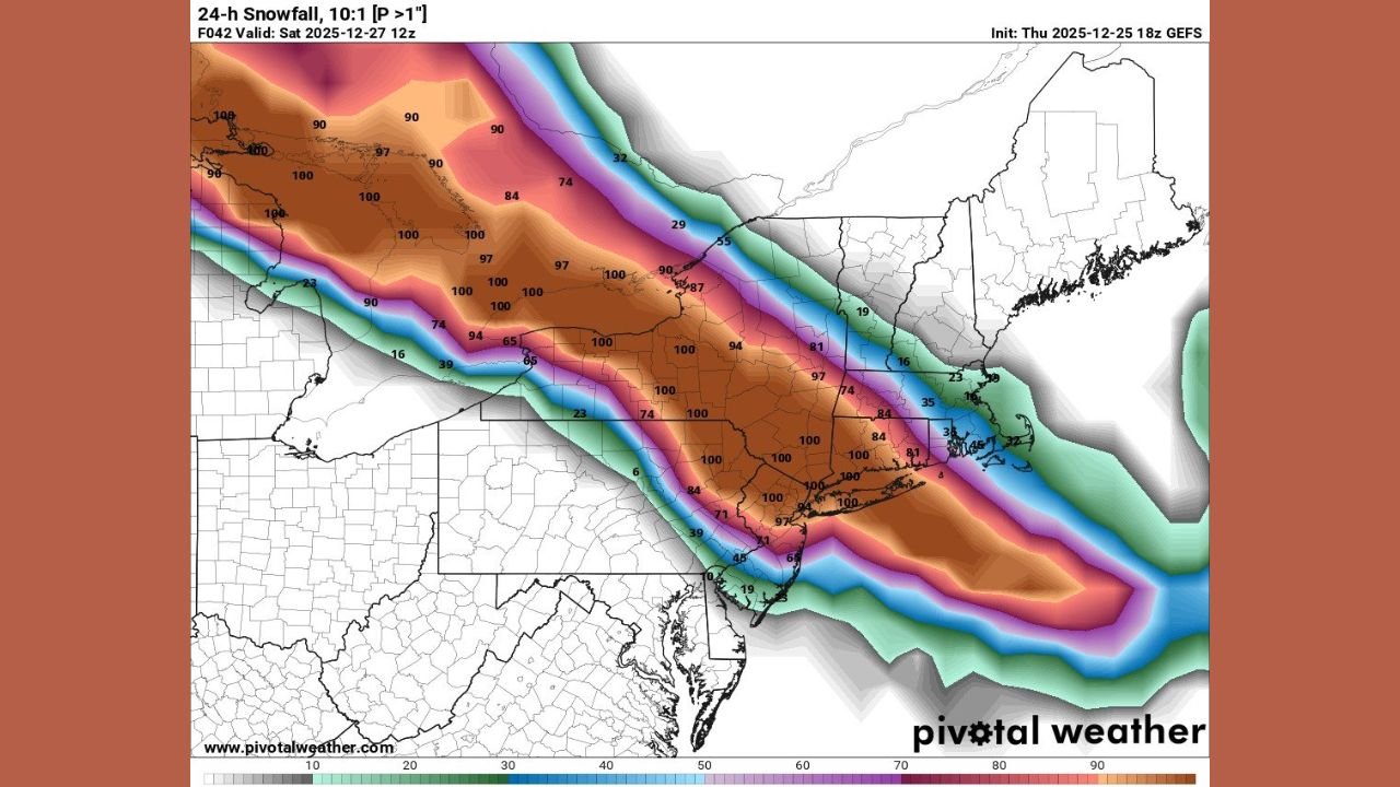
Forecast guidance shows a broad corridor of high snowfall probabilities exceeding one inch per hour stretching from central Pennsylvania into northern portions of the state. Ensemble snowfall maps indicate strong confidence in accumulating snow, with some locations likely receiving significant totals within a relatively short window.
This “gold zone” of colder air supports plowable, accumulating snow, with temperatures remaining well below freezing from the surface through much of the atmosphere. These conditions strongly favor snow over sleet or freezing rain.
Snow vs. Sleet Line Creates High Uncertainty in NEPA
Just south of the main snow band, including parts of Northeastern Pennsylvania such as Luzerne County, conditions become far more uncertain.
Forecasters warn that precipitation type may vary dramatically over short distances, creating scenarios where:
- Heavy snow is falling in one community
- Heavy sleet is falling just a few miles away
This sharp gradient could lead to uneven road conditions and rapidly changing travel hazards, especially overnight.
Warm Air Aloft Driving the Uncertainty
The core challenge with this forecast lies in a warm layer of air several thousand feet above the ground, while surface temperatures remain well below freezing — in some cases in the teens.
Weather models continue to disagree on:
- How warm this elevated layer becomes
- How thick the warm layer is
- How far north it extends
If the warm layer is thin and only slightly above freezing, snowflakes may partially melt but refreeze quickly, resulting in heavy, wet snow. If that warm layer becomes thicker or warmer, snowflakes can fully melt and refreeze on the way down, producing sleet instead of snow.
Thermal Profiles Favor Snow in Much of NEPA
Despite the uncertainty, detailed atmospheric soundings suggest snow may be more dominant than some models currently indicate.
Forecast temperature profiles at multiple levels — including near the surface and higher elevations in the atmosphere — remain well below freezing, with surface temperatures near 19°F in parts of Northeastern Pennsylvania. This setup limits the time snowflakes spend in warmer air, reducing the likelihood of complete melting.
Meteorologists caution that some models may be overestimating sleet potential, especially if the warm layer remains shallow.
Impacts Could Change Quickly
Because this storm sits on a narrow thermal boundary, small shifts in temperature or storm track could lead to major changes in precipitation type. Residents should be prepared for:
- Rapid changes from snow to sleet
- Heavier-than-expected accumulations in colder zones
- Slick, compacted road surfaces where sleet dominates
Travel conditions could deteriorate quickly, particularly overnight into early Saturday.
Bottom Line
Pennsylvania is facing a high-impact but complex winter storm, with heavy snow likely across northern and central areas, and a challenging snow-versus-sleet forecast in Northeastern Pennsylvania. Confidence is growing that snow will win out in many locations, but sleet remains a real concern near the southern edge of the cold air.
WaldronNews.com will continue monitoring updated model guidance and provide additional updates as confidence increases and conditions develop.