
United States Jet Stream Pattern Tightens as Ridge Over the Midwest Retracts West and Eastern Trough Re-Expands — Why This Is Not a True Model “Flip”
UNITED STATES — What may look like a dramatic “model flip” from one forecast run to the next is often something far less chaotic — and far more common.
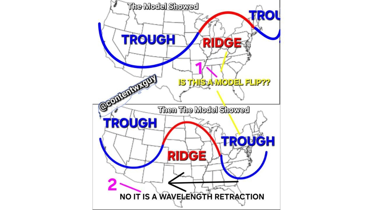
Recent model graphics show a noticeable shift in the placement of troughs and ridges across the country, sparking questions about whether guidance has suddenly reversed course. But a closer look reveals this is not a flip at all. Instead, it’s a retraction of the modeled jet stream wavelength.
What the First Model Run Showed
In the earlier depiction:
- A broad trough was positioned over the western United States.
- A pronounced ridge extended across the Midwest into the Great Lakes.
- Another trough appeared near the East Coast.
This configuration suggested warmer conditions under the ridge in the central U.S., with cooler, more unsettled weather beneath troughs to the west and east.
At first glance, that setup appeared well-established.
Then the Pattern “Shifted”
In the subsequent model run:
- The western trough remained.
- The central U.S. ridge contracted and shifted slightly west.
- A more defined eastern trough expanded along the East Coast.
To some viewers, this appeared to be a wholesale reversal of the forecast pattern — a so-called “model flip.”
But that interpretation misses what is actually happening.
The Real Explanation: Wavelength Retraction
The change reflects a contraction of the jet stream’s modeled wavelength, not a sudden atmospheric reversal.
Long-range guidance often stretches wave patterns too far east in early runs. As newer data is assimilated, models frequently “reel back” that stretch — tightening the ridge and trough structure into a more realistic configuration.
In simple terms:
- The ridge didn’t disappear.
- The trough didn’t suddenly materialize.
- The wave pattern compressed and adjusted.
This is a common correction process in medium- to long-range forecasting.
Why It Looks Like a Flip
When viewing maps side by side, the ridge appearing farther west and the eastern trough becoming more prominent can give the illusion of a pattern reversal.
However, the overall large-scale structure remains intact:
- Western troughing still present.
- Central U.S. ridging still dominant.
- Eastern troughing becoming more refined.
Rather than a flip, this is a refinement of wave placement.
Why This Matters
Understanding wavelength retraction is critical for interpreting model trends properly.
Misreading these adjustments can lead to overreactions in forecast discussions — especially regarding temperature outlooks or storm track expectations.
In many cases, what seems like volatility is simply the model correcting its own overextension from previous runs.
Bottom Line
There are not true “flips” between run-to-run ranges in this scenario.
What we’re seeing is the jet stream’s modeled wavelength contracting westward as guidance aligns closer to atmospheric reality.
As always, trend analysis over multiple runs — rather than focusing on a single snapshot — provides the clearest forecast picture.
Stay with WaldronNews.com for continued breakdowns of model trends and large-scale pattern shifts affecting weather across the United States.