
Upper Midwest and Great Lakes Brace for Major December Snowfall: Minnesota, Wisconsin, Michigan, and New York All in Line for Significant Accumulations, ECMWF Shows
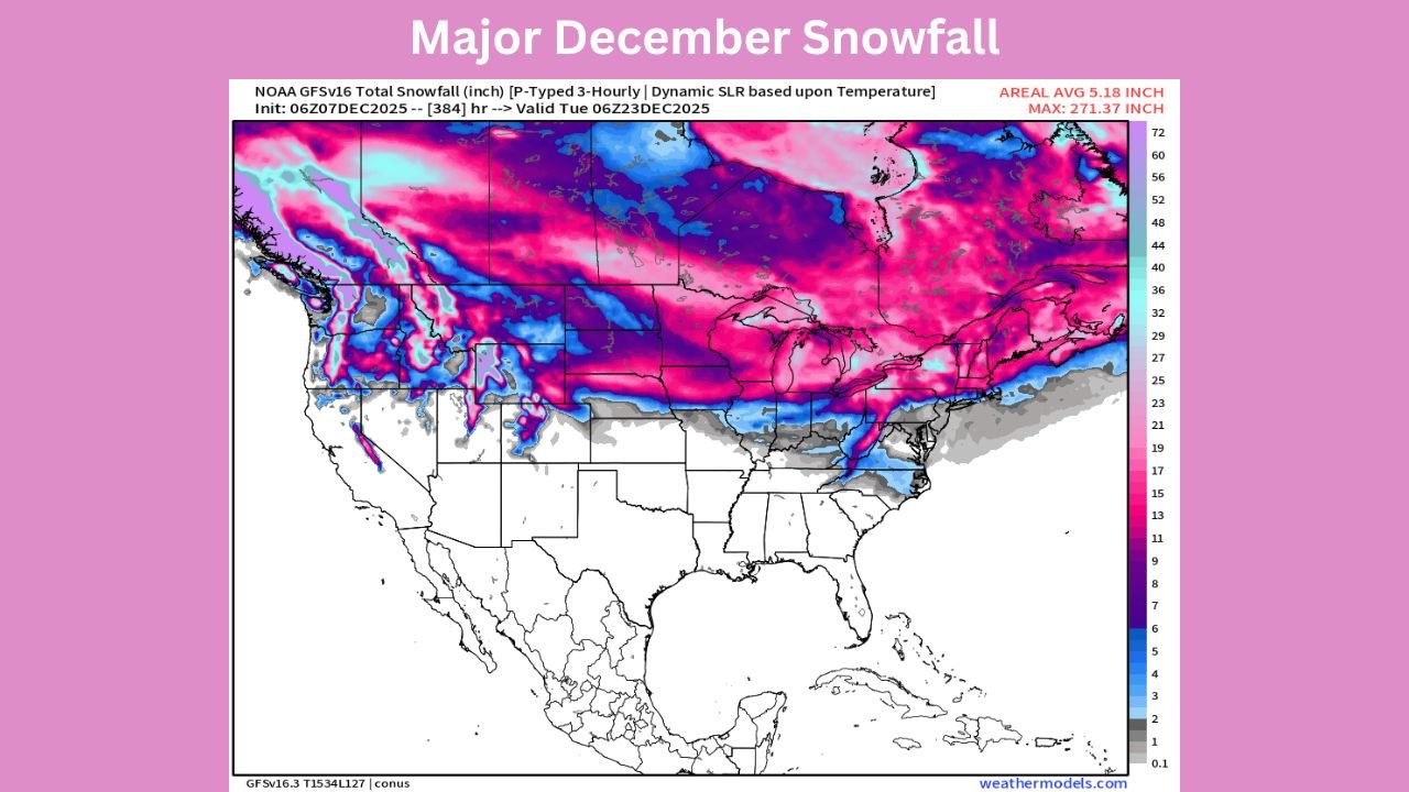
UNITED STATES — A newly released long-range snowfall projection from the ECMWF AIFS model is signaling a high-impact stretch of winter weather across several northern states, with Minnesota, Wisconsin, Michigan, and New York all positioned for significant accumulations between December 7 and December 22. The data depicts one of the strongest multi-state snow corridors of the season so far, driven by repeated storm systems and persistent cold air over the northern half of the country.
The projected totals vary from region to region, but the message is clear: millions across the Upper Midwest and Great Lakes will see disruptive snowfall over the next two weeks.
Minnesota: Deep Snow Corridor Anchored Over the Northern Plains
Minnesota sits in the heart of the projected snow band, with totals ranging widely across the state:
- Northern Minnesota: 15–22+ inches
- Central Minnesota: 10–15 inches
- Southern Minnesota: 4–8 inches
The ECMWF model favors a pattern dominated by frequent clipper systems, each adding fresh accumulation. Combined with sustained cold temperatures, snow is expected to linger and build through mid-December.
Key impact: Highway 2, I-94, and northern rural routes may see extended periods of snow-covered roadway.
Wisconsin: Widespread Moderate-to-Heavy Snowfall Likely
Wisconsin appears positioned for a broad swath of accumulation:
- Northern Wisconsin: 12–18 inches
- Central Wisconsin: 8–12 inches
- Southern Wisconsin: 3–8 inches
Lake-effect enhancement off Lake Superior may boost totals in counties such as Ashland, Iron, and Vilas. Most systems will be fast-moving but frequent, consistent with a December dominated by northern-stream energy.
Key impact: Repeated light-to-moderate events may create hazardous commutes across Madison, Milwaukee, and Green Bay.
Michigan: One of the Highest Snow Totals in the Region
Michigan stands out in the model output, with some of the highest projected totals in the entire Great Lakes basin:
- Upper Peninsula: 15–22 inches (locally higher with lake enhancement)
- Northern Lower Michigan: 10–15 inches
- Southern Michigan: 3–8 inches
The combination of synoptic snowfall and strong lake-effect bands could create extended stretches of low visibility, particularly near Gaylord, Marquette, and Traverse City.
Key impact: Travel disruptions are likely across both peninsulas due to recurring snow events layered over cold conditions.
New York: Lake-Effect Potential Adds a High-End Risk
New York state shows some of the strongest lake-effect signatures in the data:
- Western & Upstate New York: 12–20 inches
- North Country: 8–14 inches
- Central NY: 5–10 inches
Lake Erie and Lake Ontario will likely enhance totals considerably depending on wind direction. While long-range models cannot predict individual snow bands with precision, the overall pattern suggests high-impact travel days around Buffalo, Rochester, Syracuse, and Watertown.
Key impact: Localized extreme totals possible in typical lake-effect corridors.
Why This Multi-State Pattern Is Developing
Atmospheric signals highlight a classic December setup:
- A strong, southward-dipped jet stream anchoring cold air over central and eastern U.S.
- Successive Alberta Clippers, each reinforcing cold and producing fresh snowfall
- Lake-effect enhancement boosting totals downwind of the Great Lakes
- A stable cold regime that supports all-snow precipitation events
This combination leads to a prolonged period of accumulation rather than one major storm.
Travel & Safety Outlook
Even without a single blockbuster system, the cumulative effect of multiple snow events across these four states may lead to:
- Recurrent slippery highways
- Reduced visibility during active snow bands
- Snowpack build-up through mid-December
- Holiday-related travel delays in major hubs such as Minneapolis, Milwaukee, Detroit, and Buffalo
Residents should monitor daily updates as storm timing and intensity will shift.
Stay Weather-Ready Across All Impacted States
Winter weather can evolve quickly across the Upper Midwest and Great Lakes. For ongoing updates, statewide alerts, and travel-impact tracking, continue following WaldronNews.com as we monitor this developing multi-state winter pattern.