
US Tornado Hotspot Map Revealed Showing The Most Frequently Hit Towns In Every State Over The Last 75 Years
UNITED STATES — A newly analyzed dataset is shedding light on a striking reality: some towns across America have repeatedly found themselves in the path of powerful tornadoes, earning the label of true “tornado magnets.”
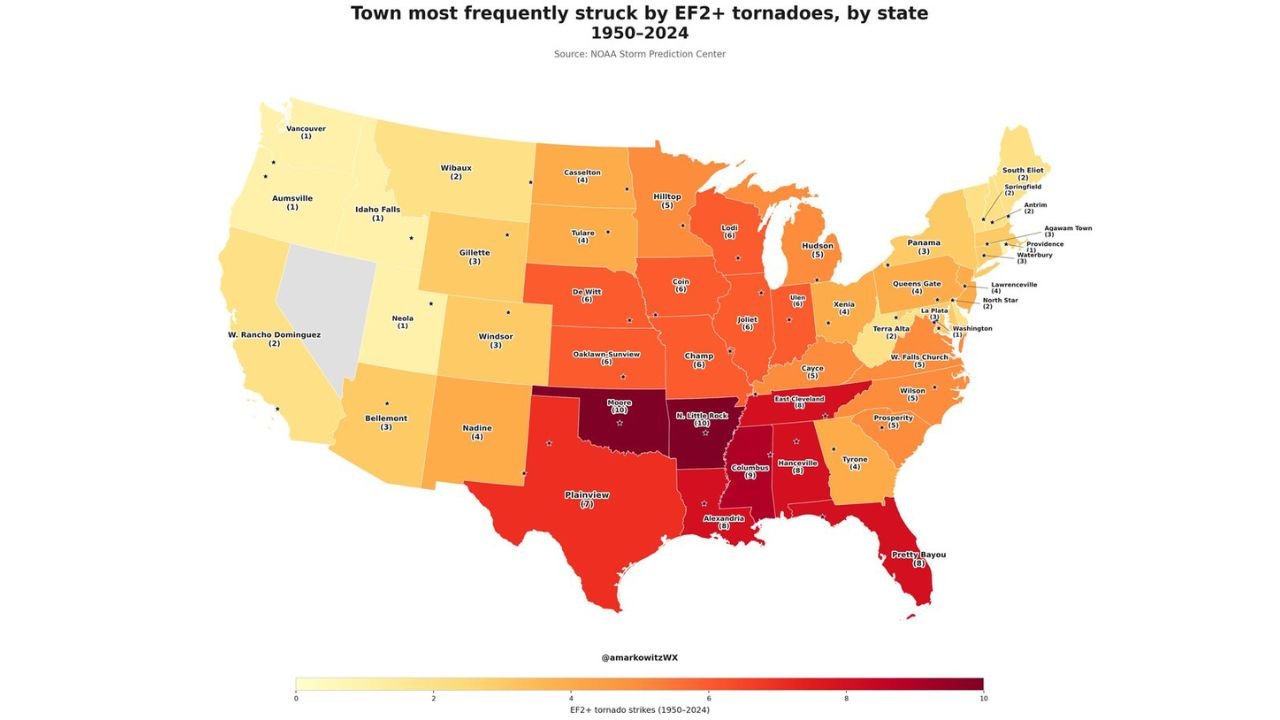
The data highlights the town most frequently struck by EF2+ tornadoes in each state between 1950 and 2024, offering a rare look into long-term severe weather patterns across the country.
Central And Southern States Dominate Tornado History
The map clearly shows that the highest concentration of repeat tornado impacts is centered across the Plains, Midwest, and Deep South, including:
- Oklahoma
- Kansas
- Arkansas
- Mississippi
- Alabama
- Louisiana
- Texas
Many towns in these states have recorded 6 to 10+ significant tornado strikes, placing them among the most repeatedly impacted locations in the United States.
Notable high-frequency areas include:
- Moore, Oklahoma
- Little Rock, Arkansas region
- Columbus, Mississippi area
- Parts of northern Alabama and central Mississippi
These regions sit squarely within what is often referred to as “Tornado Alley” and “Dixie Alley,” where atmospheric conditions frequently favor severe storm development.
Midwest Shows Strong Tornado Clusters
Beyond the southern tier, the Midwest also shows consistent tornado activity, particularly across:
- Illinois
- Missouri
- Iowa
- Indiana
Towns like:
- Joliet, Illinois
- DeWitt, Iowa
- Oak Lawn/Sun River region (Midwest cluster)
have experienced multiple EF2+ tornadoes over the decades, highlighting how the tornado threat extends well beyond the traditional Plains.
Eastern States Still See Notable Activity
While less frequent than the central U.S., the data confirms that tornadoes are far from rare in the eastern half of the country.
States like:
- North Carolina
- Virginia
- Pennsylvania
- New York
show towns with 3 to 5 significant tornado events, proving that severe weather risk reaches deep into the East Coast.
Western US Sees Minimal But Not Zero Risk
In contrast, the western United States shows much lower frequency, with most states recording:
- 0 to 2 EF2+ tornadoes in their most-impacted towns
However, even in these regions:
- Tornadoes do occur occasionally
- Some localized areas still show repeat impacts over decades
Why These Towns Become “Tornado Magnets”
The repeated impact on certain towns is not random. It reflects:
- Geography and terrain
- Storm track patterns
- Frequent alignment of atmospheric ingredients
Areas across the central U.S. often sit in corridors where:
- Warm, moist air from the Gulf of Mexico meets
- Cooler, drier air from the north and west
This creates the perfect environment for recurring severe storms and tornadoes.
A Reminder That Tornado Risk Is Long-Term
This data reinforces an important point:
Tornado risk is not just about single events — it’s about long-term patterns.
Communities that appear on this map have faced repeated severe weather threats for decades, emphasizing the need for:
- Strong warning systems
- Community preparedness
- Awareness of historical risk
What This Means For Residents
If your town or region appears in these high-frequency zones:
- You are in an area with proven tornado history
- Future events are more likely compared to other regions
- Preparedness is not optional — it is essential
Understanding these patterns helps explain why some areas experience repeated severe weather events while others rarely do.
Stay Informed And Prepared
This long-term tornado map is a powerful reminder that severe weather risk is deeply tied to geography and history across the United States.
Stay with WaldronNews.com for more in-depth weather analysis, storm tracking insights, and critical updates that help you stay prepared year-round.