
Utah Braces for Back-to-Back Spring Storms as Widespread Valley Rain and Heavy Mountain Snow Target Northern and Central Regions
UNITED STATES — Utah is shifting into a far more active and unsettled weather pattern, with multiple storm systems lining up over the next week — a setup that could bring widespread valley rain, heavy mountain snow, and no real stretch of dry weather, especially across northern and central parts of the state.
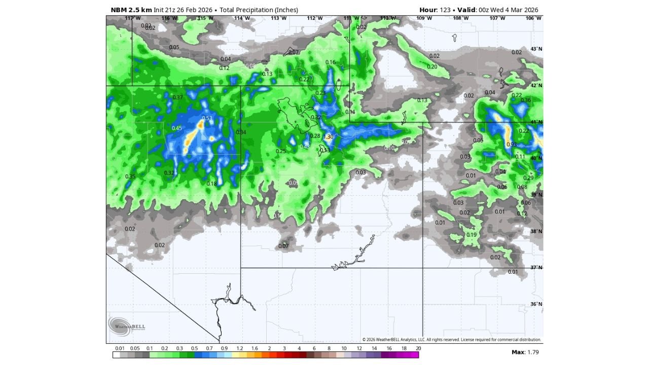
Latest high-resolution model guidance through early March 4 shows precipitation spreading across much of Utah, with the heaviest totals focused in the mountains and more persistent rainfall across valleys from central into northern areas.
Storm Train Setting Up Over the Great Basin
Rather than a dominant high-pressure ridge bringing calm spring warmth, the jet stream remains active and progressive across the Western U.S. That means several disturbances will move through in quick succession.
Forecast precipitation projections show:
- Moderate rainfall totals across many northern and central valleys
- Heavier pockets embedded in mountain ranges
- Some localized higher amounts in central Utah
- Snow concentrated at higher elevations
The overall pattern favors repeated waves instead of a single quick system.
Friday’s Calm Won’t Last
Forecasters note that Friday appears to be one of the quieter windows statewide:
- Mild daytime temperatures
- Limited precipitation
- Generally calmer conditions
But that brief break sets the stage for the next round.
Showers Return Saturday, Lingering Into Sunday
By Saturday afternoon and evening, isolated showers begin to redevelop — mainly across northern Utah.
While not widespread initially, scattered activity increases late Saturday and could linger into Sunday, particularly in northern counties. Snow levels remain elevated during this phase, keeping most lower elevations in rain.
Monday’s Stronger System Brings Broader Impact
A more organized storm pushes in Monday, significantly increasing precipitation coverage.
Model data suggests:
- Widespread valley rain
- Steadier mountain snowfall
- Embedded heavier precipitation bands
Snow levels are projected to hover near 8,000 feet, meaning ski resorts and higher peaks stand to benefit most, while valley communities deal primarily with rain.
Another Colder Storm Possible Later Next Week
Longer-range signals point toward another storm system around Thursday — and this one could introduce colder air.
If temperatures trend downward:
- Snow levels could fall
- Mountain accumulations would increase
- Some higher elevation valleys could see mixed precipitation
Details will become clearer as that system draws closer.
No Extended Dry Spell Ahead
Perhaps the biggest headline: there are currently no strong signals of a prolonged dry stretch.
Instead, Utah appears locked into a more dynamic spring-like regime, where:
- Systems roll through every few days
- Temperatures fluctuate
- Precipitation remains frequent
For water supply and mountain snowpack, that’s beneficial. For travel and outdoor plans, it means staying weather-aware.
The Bottom Line
Utah is entering a stretch of back-to-back spring storms, with northern and central areas most likely to see repeated rounds of valley rain and mountain snow. A brief calm on Friday gives way to weekend showers, a stronger Monday system, and possibly another colder storm late next week.
WaldronNews.com will continue tracking Western storm developments and their potential downstream impacts across the central United States as this active pattern evolves.