
Utah Mountains and Ski Resorts Get Relief as Two Storm Systems Bring Rain and Snow Tuesday Through Friday After 25 Days of No Precipitation and 9 Ski Resort Closures
SALT LAKE CITY, UTAH — After an agonizing 25 consecutive days without a drop of precipitation, record-breaking heat and the forced closure of 9 ski resorts across Utah, relief is finally on the way. Models have trended significantly wetter over the past 24 hours, and two separate storm systems are now lined up to bring much-needed rain and mountain snow to Utah this week — the first arriving Tuesday afternoon through Wednesday, and a second and potentially stronger system following Thursday into Friday morning. For ski resorts, mountain communities and drought-stressed landscapes across Utah, this week represents the first meaningful moisture since a dry stretch that has been as damaging as any in recent memory for the state.
Two Storms — What to Expect and When
Storm 1 — Tuesday afternoon through Wednesday: The first system arrives Tuesday afternoon and pushes through into Wednesday, bringing rain to the valleys and snow to the mountains. The NBM 2.5 km precipitation model initialized March 30 shows totals for the Wasatch and Uinta mountain ranges in the range of 1.0 to 2.88 inches of liquid equivalent precipitation through the end of the week — with the highest totals concentrated in the central Utah mountain ranges. This first storm breaks the 25-day dry streak and begins replenishing the snowpack that was devastated by the March heat wave.
Storm 2 — Thursday through Friday morning: The second system arrives Thursday and is expected to be the stronger of the two. Models show this system tapping into deeper moisture, with snow totals at higher elevations potentially reaching significant levels across the Wasatch, Uinta and surrounding ranges. The NBM total snow forecast shows pink and magenta colors — representing the heaviest snow accumulations — concentrated across the central Utah mountains with isolated areas potentially seeing very high totals through Saturday April 4.
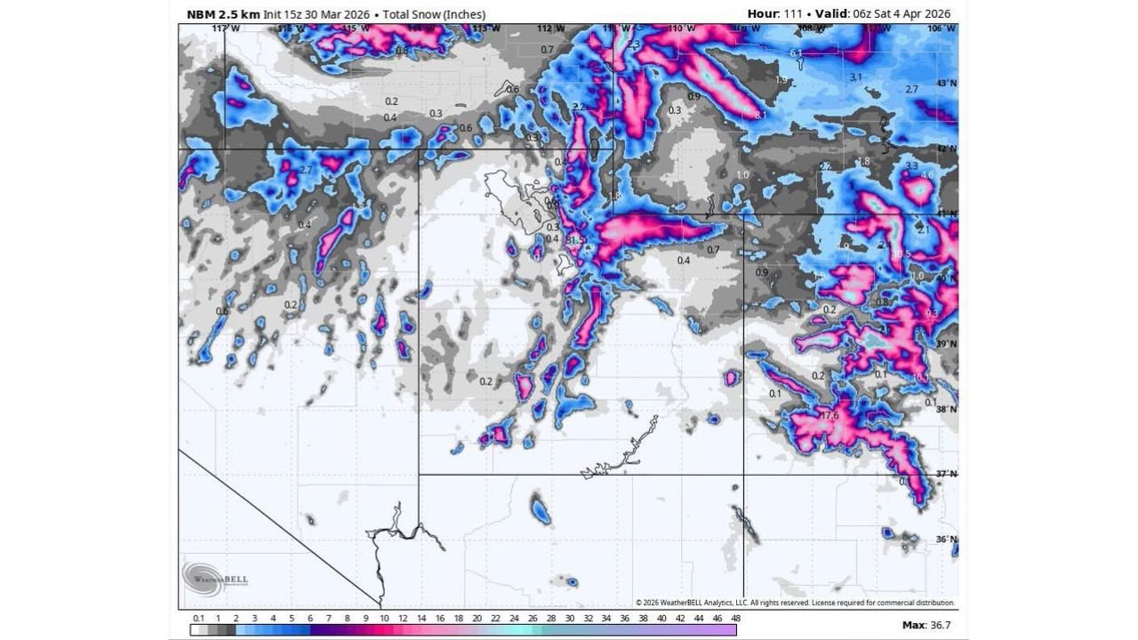
What the Precipitation and Snow Maps Show
The NBM precipitation map valid through Saturday April 4 shows:
- Central Utah mountains — up to 2.88 inches of liquid equivalent precipitation, the highest totals in the state
- Wasatch Front mountains above Salt Lake City — 1.20 to 1.42 inches of liquid precipitation, translating to significant snow at ski resort elevations
- Northern Utah mountains — 0.85 to 1.19 inches across portions of the Cache and Rich County mountain corridors
- Southern Utah — lighter totals of 0.16 to 0.42 inches, with the moisture corridor favoring the northern and central portions of the state
The NBM total snow map valid through April 4 shows even more dramatic potential at higher elevations, with the pink-to-magenta color range indicating areas that could see over 12 to 20 or more inches of snow across the highest terrain of the central Utah Wasatch and Uinta ranges. The maximum snow value on the model reaches 36.7 inches — though that would represent the highest possible accumulation in the most favorable spots and should not be expected as a widespread total.
Why This Week Matters So Much for Utah
Twenty-five consecutive days without precipitation is not just an inconvenience — it is a crisis for a state as dependent on mountain snowpack as Utah. The snowpack feeds the rivers, fills the reservoirs, sustains agriculture and keeps ski resorts open through the spring season. When 25 dry days come on top of record March heat — heat that was simultaneously melting the existing snowpack at an accelerated rate — the cumulative damage to Utah’s water supply picture is significant.
The 9 ski resort closures that resulted from the combination of heat and zero new snow are a visible symbol of what an extended dry and warm stretch does to mountain environments in Utah. Resorts that normally operate deep into April found themselves shutting down weeks early as conditions deteriorated beyond the point of safe or enjoyable skiing.
This week’s two-storm sequence will not fully undo the damage from 25 days of drought and record heat — but it is a meaningful start and a genuine turning point in the pattern for Utah.
What This Means for Ski Resorts and Mountain Recreation
For Utah ski resorts that have been forced to close or dramatically reduce operations, the arrival of meaningful snow from Storm 1 Tuesday to Wednesday and Storm 2 Thursday to Friday creates the possibility of at least partial reopening and surface improvement heading into the weekend. The higher the elevation of the resort and the more directly it sits in the path of the moisture corridor, the more snowfall it can expect from these two systems.
Mountain recreationists — hikers, backcountry skiers and snowshoers — should be aware that new snow accumulation combined with warming temperatures during storm breaks creates elevated avalanche risk across Utah’s mountain ranges following these systems. Check avalanche forecasts from the Utah Avalanche Center before heading into the backcountry this week.
What to Watch Next
- Tuesday afternoon storm arrival — the exact timing of when rain reaches the Salt Lake Valley and snow begins at ski resort elevations
- Storm 1 snow totals — how much accumulation the Wasatch resorts pick up Tuesday night through Wednesday
- Storm 2 intensity — whether Thursday’s stronger system delivers on the model’s higher snow totals across the central Utah mountains
- Ski resort reopening announcements — watch for resorts to update their operating status as the week progresses and new snow accumulates
- Valley rain totals — whether Salt Lake City, Provo and Ogden receive meaningful rainfall from either storm system
- Reservoir inflow — whether the combined precipitation from both storms produces measurable inflow into Utah’s major reservoirs
Residents across Salt Lake City, Provo, Ogden and the broader Utah Wasatch Front can expect rain in the valleys and significant snow in the mountains over the next four days — a welcome change after one of the driest and hottest March stretches in Utah history.
WaldronNews.com will continue tracking both storm systems and provide updated snowfall totals and resort condition information as the week develops across Utah.