
Utah Storm System Targets Salt Lake City, Upper Cottonwoods and Uinta Mountains With 8+ Inches of High-Elevation Snow as Rain Dominates Lower Valleys
UTAH — A new storm system is set to arrive late Saturday across northern Utah, but the more impactful phase of the system is expected Monday into early Tuesday, bringing steadier and more widespread precipitation to the region.
Forecast guidance shows showers developing first in northern Utah this weekend, though initial activity will be somewhat spotty. Snow levels will remain high at the start, mainly above 8,500 feet, keeping most lower elevations in rain.
Weekend: Spotty Showers, High Snow Levels
As the system begins to move in late Saturday, precipitation will be scattered across northern Utah, including areas near:
- Salt Lake City
- Ogden
- Park City
- Surrounding Wasatch Front communities
However, with snow levels staying elevated — primarily above 8,500 feet — only the highest peaks will see accumulating snow during the initial phase. Valleys and lower foothills will largely experience rain.
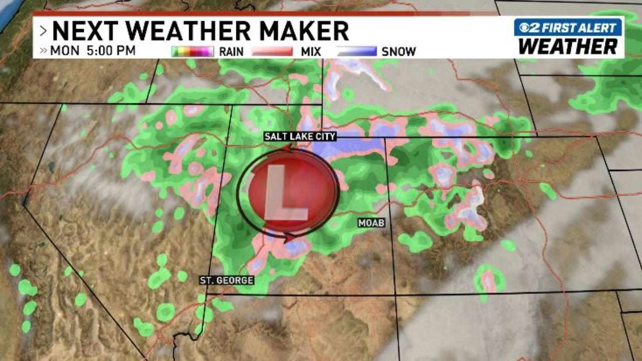
Monday Through Early Tuesday: Stronger Impacts Arrive
The stronger portion of the system pushes through Monday and lingers into Tuesday morning. During this period:
- Precipitation becomes more widespread and steadier.
- A surface low is positioned near central Utah, enhancing coverage.
- Rain spreads across much of northern and central Utah.
Snow levels will drop slightly but are still expected to remain relatively high for this time of year — around 7,000 feet. That means most valley communities, including Salt Lake City, Provo, and Ogden, will continue to see mainly rain rather than snow.
Mountains the Big Winners: 8+ Inches Possible
The real beneficiaries of this system will be the higher elevations.
Forecast projections indicate that the upper Cottonwoods and the Uinta Mountains could receive 8 inches or more of wetter, heavier snow, primarily above 8,500 feet.
This type of snow is typical with higher snow levels and warmer storm systems, often resulting in denser accumulations compared to mid-winter powder events.
Ski areas in the higher terrain may see meaningful refresh totals, especially in the most elevated zones.
Cooler Air Follows — But No Major Cold Blast
After the storm exits Tuesday morning, cooler air will filter into the region. However, this does not appear to be a sharp Arctic-style cold blast.
Instead, temperatures will simply step down from recent warmth, returning closer to seasonal norms rather than plunging dramatically below average.
What to Expect
- Late Saturday: Spotty showers begin across northern Utah.
- Monday: Steadier, more widespread rain in valleys; accumulating snow above 7,000–8,500 feet.
- Monday Night–Tuesday Morning: Peak impacts before the system tapers off.
- Post-Storm: Cooler but not frigid conditions.
Travelers heading into the higher terrain of the Cottonwoods or Uintas should be prepared for winter driving conditions at elevation, while valley residents should plan for periods of rain.
Stay with WaldronNews.com for continued updates as this storm system approaches and moves through the region.