
Utah’s Alta Ski Area Reports 260 Inches So Far This Season Nearly 12 Feet Below Average as Western Snowpack Falls Behind and Warmer Temperatures Threaten Further Melt
UTAH — Alta Ski Area, widely recognized as Utah’s snowiest resort, is reporting a major snowfall deficit for the 2025–2026 season, underscoring a broader snowpack shortfall across much of the western United States.
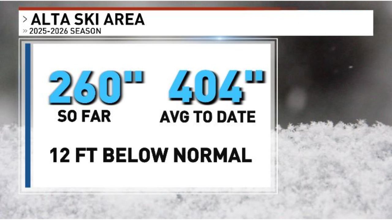
According to seasonal totals, Alta has recorded 260 inches of snow so far, compared to an average-to-date of 404 inches. That places the resort approximately 12 feet below normal for this point in the winter season.
A Significant Gap in Utah’s Snowiest Location
Alta Ski Area typically leads Utah in annual snowfall, often serving as a benchmark for how the broader Wasatch Range is performing during the winter months.
However, this season’s numbers tell a different story:
- 260 inches recorded so far
- 404 inches average by this date
- Roughly 12 feet below normal
A nearly 144-inch deficit at a location known for prolific snowfall highlights just how underperforming this winter has been.
For a resort that frequently surpasses 500 inches in strong seasons, falling this far behind average raises concerns not only for recreation but also for regional water supply outlooks later this year.
Western Snowfall Running Well Below Normal
The situation is not limited to Utah.
Much of the western United States has been tracking below seasonal snowfall averages. The broader pattern has featured fewer sustained storm cycles and more frequent mild periods, limiting snow accumulation at higher elevations.
Snowpack in the West plays a critical role in:
- Spring runoff
- Reservoir replenishment
- Agricultural irrigation
- Municipal water supply
When premier snow locations like Alta are running significantly behind average, it often reflects widespread shortfalls across surrounding mountain ranges.
Warmer Temperatures Add to Concerns
Adding to the challenge, forecasts indicate warmer temperatures arriving next week, which could begin eroding portions of the existing snowpack.
When mild air masses move into the region during late winter:
- Lower-elevation snowpack can diminish rapidly
- South-facing slopes see accelerated melt
- Water retention timing may shift earlier than normal
If warmth continues without significant replenishing storms, the seasonal deficit could widen further before winter officially transitions into spring.
What This Means Moving Forward
While 260 inches of snow is still substantial in absolute terms, the comparison to the 404-inch seasonal average underscores how much the region is lagging.
The 12-foot deficit is particularly notable given Alta’s reputation for dependable snowfall totals.
Water managers and recreation industries alike will be watching closely to see whether late-season storms can narrow the gap — or whether this season will go down as one of the more underperforming snow years in recent memory.
Stay with WaldronNews.com for continued updates on snowpack conditions and western weather trends as the season progresses.