
Utah’s Wasatch Front Braces for First Meaningful Valley Snow of the Season as Strong Cold Front Targets Salt Lake City, Provo and Ogden Next Week
UTAH — Confidence is increasing that parts of northern Utah could see their first meaningful valley snowfall of the season next week, as forecast models come into stronger agreement on a sharp cold front sweeping into the state by Wednesday morning.
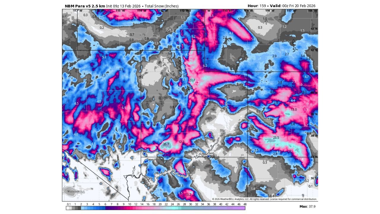
According to the latest National Blend of Models (NBM) 2.5 km guidance, rain is expected to transition to snow across lower elevations along the Wasatch Front — including Salt Lake City, Ogden, and Provo — as significantly colder air settles in behind the front.
While timing and exact snow totals are still being refined, the overall setup suggests this system could deliver widespread accumulating snow not just in the mountains, but down into several populated valley locations.
Cold Front Arrives Wednesday Morning
Model data initialized February 13 and valid into early Friday, February 20, shows a strong push of cold air dropping into northern Utah by Wednesday morning. The setup favors:
- Rain initially at valley floors
- Rapid cooling as the front passes
- A transition from rain to snow in lower elevations
- Continued snow showers as colder air deepens
This type of dynamic cooling often increases the likelihood of measurable snow in areas that may start as rain.
Forecasters note that this system appears more organized than previous weak disturbances that have passed through in recent weeks.
Wasatch Front: Several Inches Possible
The NBM snowfall projection highlights enhanced totals along the Wasatch Front and surrounding higher terrain. While final amounts remain uncertain, early guidance suggests:
- Salt Lake Valley: Potential for several inches if cold air arrives quickly enough
- Ogden and northern Davis/Weber counties: Higher confidence in measurable accumulation
- Provo and Utah Valley: Snow likely, especially if precipitation lingers into colder air
- Bench areas and foothills: Greater accumulation potential than valley floors
Higher elevations east of Interstate 15 — particularly along the Wasatch Range — show stronger signals for significant snowfall totals.
Mountain areas near Park City, Big Cottonwood Canyon, Little Cottonwood Canyon, and Sundance could see considerably higher amounts compared to valley locations.
Mountain Snowfall Could Be Substantial
The model map indicates pockets of heavier totals in mountainous terrain, with some localized areas exceeding double-digit snowfall amounts. This includes parts of:
- The central Wasatch
- Areas east of Salt Lake City
- Elevated terrain near the Utah–Wyoming border
Though exact numbers will fluctuate as models update, this system carries the potential to deliver a meaningful boost to snowpack in the region.
Why This System Looks Different
Meteorologists point to increasing model agreement as a key factor. Earlier forecasts showed variability in timing and intensity, but recent runs are aligning on:
- A defined cold frontal passage
- Adequate moisture
- A sustained period of colder air following the front
That combination raises the probability of valley snow — something that has been limited so far this season.
However, small changes in temperature profiles could significantly affect totals in lower elevations. A delay in cold air arrival would reduce valley accumulations, while a faster transition would increase snow coverage.
Travel Impacts Possible Along I-15 and I-80
If current projections hold, commuters could encounter slick roads during or after the Wednesday frontal passage, especially during early morning or evening hours.
Potential impact zones include:
- Interstate 15 corridor from Provo through Salt Lake City to Ogden
- Interstate 80 through Parleys Canyon
- Bench and foothill neighborhoods prone to quicker snow accumulation
Mountain passes are more likely to see steady snow and winter driving conditions.
Still Time for Adjustments
Forecasters caution that details remain fluid, particularly regarding:
- Exact timing of the rain-to-snow transition
- Snowfall rates during peak precipitation
- Duration of post-frontal snow showers
Confidence is trending upward, but final snowfall maps will continue to evolve over the coming days.
What Residents Should Watch For
Utah residents along the Wasatch Front should monitor updates as:
- Temperatures are refined
- Snow level forecasts are adjusted
- Accumulation probabilities become clearer
If the colder solution verifies, this could mark the first widespread valley snow event in some time.
WaldronNews.com will continue tracking this developing system and provide updates as new data becomes available.