
Virginia and Maryland Stuck on the Cool Side of a Sharp 200-Mile Temperature Divide as Clouds and Fog Delay True Warm-Up
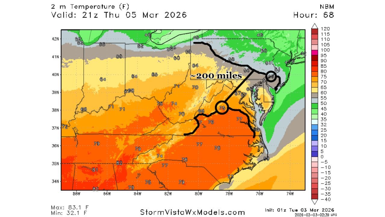
UNITED STATES — A sharp temperature gradient stretching across the Mid-Atlantic is creating a dramatic 200-mile divide between early-spring warmth and stubborn cooler air, with clouds and limited sunshine likely delaying the full warm-up through the end of the workweek.
New model projections valid Thursday, March 5 show temperatures pushing into the 70s across portions of southern and central Virginia, while areas just north — including parts of northern Virginia, Maryland, and Pennsylvania — remain locked in the 50s and lower 60s.
A Tight Gradient Sets the Stage
Temperature guidance highlights:
- Central and southern Virginia: mid-70s possible
- Northern Virginia into Maryland: low to mid-60s
- Pennsylvania: 50s to low 60s
That’s a sharp contrast over roughly a 200-mile span — a classic strong thermal gradient.
When gradients tighten like this, forecasting becomes more complicated, especially when sunshine is limited.
Limited Sunshine a Major Factor
Cloud cover projections show widespread gray conditions across:
- Virginia
- Maryland
- West Virginia
- Portions of Pennsylvania
With limited solar heating, daytime highs may struggle to fully realize the warmer air mass trying to advance northward.
Fog and scattered showers Tuesday through Thursday — possibly lingering into Friday — could further slow the warming trend.
60s Likely Midweek — 70s Waiting in the Wings
While temperatures in the 60s appear likely across much of Virginia by mid-to-late week, forecasters suggest:
- 70s may not become widespread until Friday or Saturday
- Sunshine returning will be the key ingredient
If breaks in the clouds develop sooner, some locations could jump quickly into the mid-70s. If not, the warm air may stay just to the south a bit longer.
Why Gradients Matter
Strong temperature boundaries often:
- Stall advancing warm fronts
- Create uncertainty in high temperature forecasts
- Influence where precipitation tracks
Until the gradient relaxes and more consistent sunshine mixes in, the region may experience a bit of a temperature rollercoaster.
Broader Pattern Signals Spring Is Trying
Despite short-term cloud challenges, the larger pattern still favors warming. Southerly flow continues to pump milder air northward, and once cloud cover thins, readings should respond quickly.
The key question remains timing.
Bottom Line
- Sharp 200-mile temperature divide across the Mid-Atlantic
- Clouds and fog limiting warming through Thursday
- 60s common midweek, 70s more likely by Friday or Saturday
- Sunshine will determine how fast the warm-up fully takes hold
While true spring warmth is knocking on the door, it may take a little patience before the Mid-Atlantic fully breaks into the 70s. Stay with WaldronNews.com for continued updates on temperature trends and forecast adjustments as conditions evolve.