
Virginia and North Carolina Set for Heavy Snow as Winter Storm Gianna Targets the Carolinas With Widespread 5–12 Inch Totals
UNITED STATES — A strengthening winter storm is expected to bring widespread accumulating snow across Virginia, North Carolina, and parts of South Carolina from Friday through Sunday, with forecast data showing the heaviest snowfall centered over central and eastern North Carolina and southeastern Virginia.
Unlike recent Southern winter systems, this storm is expected to be all snow, increasing the risk of significant travel disruptions across multiple states.
Winter Storm Gianna Brings a Clear Snow Bullseye
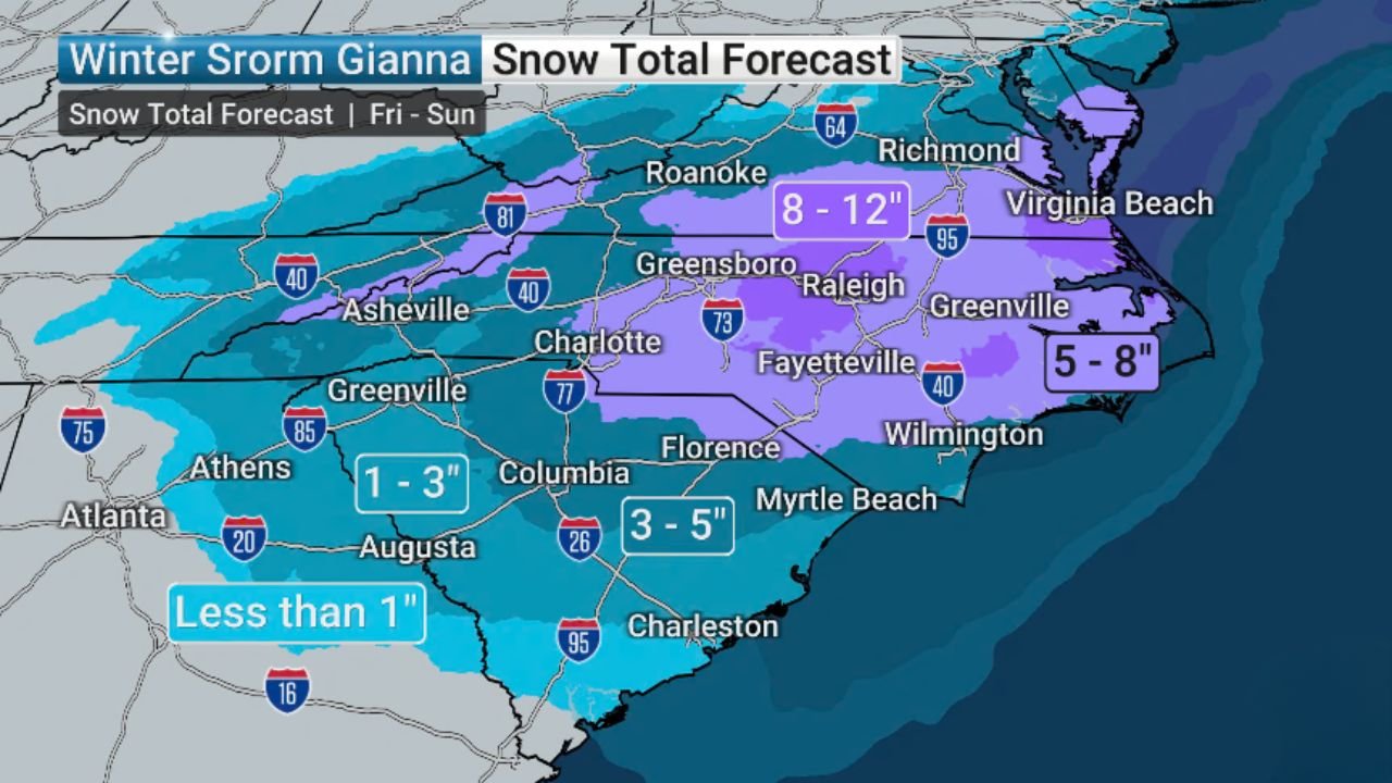
Snowfall forecasts indicate a well-defined corridor of heavier snow, stretching from central North Carolina into southeastern Virginia, with surrounding areas still expected to see meaningful accumulation.
Forecast ranges from the data include:
- 8–12 inches across parts of central North Carolina into southeastern Virginia, including areas near Raleigh, Greensboro, and Richmond
- 5–8 inches across eastern North Carolina, including coastal-inland transition zones
- 3–5 inches across portions of South Carolina, including areas near Columbia and inland coastal counties
- 1–3 inches across western South Carolina and northeast Georgia
- Less than 1 inch across parts of central and southern Georgia
This setup places Virginia and North Carolina squarely in the storm’s core, with South Carolina still facing impactful snowfall.
Major Travel Disruptions Likely Across the Carolinas and Virginia
With snow expected to fall over an extended period from Friday into Sunday, impacts are likely to compound.
Key concerns include:
- Snow-covered interstates including I-40, I-95, I-77, and I-85
- Hazardous driving conditions across metro areas such as Raleigh, Greensboro, Fayetteville, Wilmington, and Richmond
- Slower emergency response and potential delays to weekend travel plans
Even coastal-adjacent areas, which often miss major snow, are included in the accumulation zone this time.
South Carolina Still in the Impact Zone
While totals decrease farther south, South Carolina is not spared.
- 3–5 inches are possible across central parts of the state
- Northern and western areas still face 1–3 inches, enough to create slick roads
- Charleston and far southern areas appear to remain on the lower edge of accumulation
The gradient suggests small shifts in the storm track could raise totals locally.
Why This Storm Is Different
Forecast data confirms:
- All precipitation is expected to fall as snow
- No freezing rain or sleet signal appears in the current guidance
- Cold air is firmly in place across the region
This increases confidence that snow will accumulate efficiently, even during daylight hours.
What to Watch Going Forward
Forecasters continue refining:
- Exact placement of the heaviest snow band
- Localized totals within the 8–12 inch zone
- Potential expansion or contraction of snowfall farther south
Confidence is already high that Virginia and North Carolina will see impactful winter weather, with South Carolina closely watching trends.
WaldronNews Weather Alert
Winter Storm Gianna is shaping up to be a high-impact snow event for Virginia and North Carolina, with widespread snow also expected across the Carolinas and parts of Georgia. Travel conditions are likely to deteriorate from Friday through the weekend.
Stay with WaldronNews for continued updates as snowfall totals and timing are refined.