
Virginia Braces for a Week of Alberta Clipper Storms as Repeated Snow Bursts and Arctic Air Move Into the Mid-Atlantic
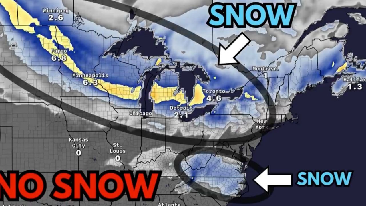
VIRGINIA — A busy week of Alberta Clipper storms is setting up across the eastern United States, bringing multiple rounds of accumulating snow, bursts of Arctic air, and fast-changing road conditions from Sunday through Saturday. Meteorologists say Virginia will be one of the key East Coast states impacted early in the pattern, with chances for additional snowfall as later systems move through.
This week’s setup is driven by the Polar Jet Stream, which has dipped southward, allowing a parade of cold fronts and compact snow systems to slide across the Mid-Atlantic.
Here is the full breakdown of what Virginia can expect.
1. Sunday into Monday: First Snowmaker Targets Virginia
A quick-hitting system drops 1 to 4 inches of snow across parts of Virginia and North Carolina.
Winter Weather Advisories and Winter Storm Watches have already been issued in some areas, and the setup is very similar to last week’s early-season snowfall event.
This system is expected to bring:
- Moderate snow bands during the morning and afternoon
- Rapid accumulations, especially in the western and central regions
- Slippery travel conditions across interstates and rural roadways
2. Monday Night into Tuesday: Snow Chances Shift North
The next Alberta Clipper is weaker and moves primarily across the Upper Midwest, but Virginia remains close enough to see leftover moisture and lingering flurries.
Accumulations will be minimal, but colder air continues filtering down from the north.
3. Tuesday into Wednesday: Strongest System of the Week
A more potent Clipper sweeps from the Midwest into the Great Lakes and the interior Northeast, drawing colder air down over the Mid-Atlantic.
While this system brings heavier snow to Minnesota, Wisconsin, and Michigan, Virginia may still see:
- Light snow or a dusting, mainly in the western mountains
- Wind-driven flurries east of the Appalachians
- Wind chills dropping significantly as the Arctic air mass deepens
Interior Northeast regions may receive several inches, but southern Mid-Atlantic states like Virginia will see lighter impacts.
4. Thursday into Friday: Light Snow Returns
Another Clipper slides southward, pushing light snow into parts of the Midwest and Mid-Atlantic.
For Virginia, this system could bring patchy snow showers, especially across the Blue Ridge and Shenandoah Valley, though totals remain low.
Even without major accumulation, the repeated cold shots keep road surfaces icy and temperatures below normal.
5. Saturday: Additional Accumulating Snow Possible
A fourth Alberta Clipper rounds out the week and may bring more organized snow bands into:
- Western Virginia
- Southwest Virginia
- Potentially parts of central Virginia
Forecasters warn that while these systems are small, they can deliver quick bursts of moderate snow, catching drivers off guard.
A Week of Snow Bursts, Not a Major Storm
Meteorologists stress that none of this week’s systems are blockbuster winter storms.
Instead, the concern is frequency — with each disturbance adding a new coating of snow and reinforcing Arctic air.
This means:
- Travel disruptions may occur several days in a row
- Snow may accumulate gradually, especially in western Virginia
- Temperatures will run colder than normal across the entire state
This pattern favors northern and elevated regions of Virginia, while southern areas see lighter coverage.
What Virginia Residents Should Expect Overall
- 1 to 4 inches with the Sunday–Monday system
- Light flurries midweek
- Another chance of accumulating snow by Saturday
- Much colder air behind each system
- Potential morning ice hazards throughout the week
Forecasters describe the setup as a classic December Alberta Clipper pattern, fast, cold, and consistently snowy for the Mid-Atlantic.
Follow Winter Weather Updates
How is the snow shaping up in your part of Virginia?
Share your local conditions and stay updated with continuous winter coverage at WaldronNews.com, where we track every storm affecting your community.