
Virginia Could See Light Weekend Snow as Weather System Weakens East of the Appalachians, Forecast Shows
VIRGINIA — Forecast Trends Show a Weakening Weekend System, but Light Snow Still Possible, A developing weather system heading into the weekend is now expected to weaken as it moves east of the Appalachian Mountains, but Virginia may still see light snowfall on Saturday, according to new forecast analysis and probability maps released Tuesday.
Meteorologists tracking the setup noted that the disturbance expected Friday night into Saturday will likely lose strength as it approaches the East Coast, reducing the chances of widespread or significant accumulation. Even so, the system may maintain enough moisture and lift to deliver light snow to parts of Virginia, especially in higher elevations or areas closer to the Blue Ridge.
This trend comes as multiple forecast datasets begin to align on a similar outcome: weakening energy aloft, less concentrated snowfall bands, and lower overall impacts.
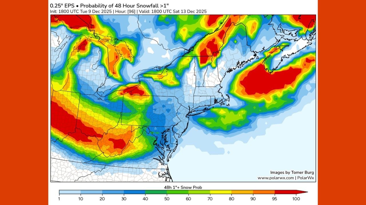
What the Snowfall Probability Maps Reveal
Several updated snowfall-probability maps show the evolving picture more clearly.
Across the Mid-Atlantic and Northeast, the probability of receiving at least 1 inch of snow over a 48-hour period varies significantly depending on the model dataset. Key observations include:
- Lower probabilities across Virginia, generally in the 10–30% range
- A stronger signal for snowfall stretching across Ohio, Pennsylvania, and into New England
- Higher probabilities (60–90%) concentrated well north of Virginia, particularly across interior New York, northern Pennsylvania, and parts of Michigan
- A consistent eastward shift of heavier snow potential, with most impacts remaining north of the Mid-Atlantic
The maps support the developing view that the storm will weaken after crossing the Appalachians, leaving Virginia on the lighter side of the system.
Why the Weekend System Is Weakening
Forecast discussions point to the disturbance “shearing out,” meaning the system’s upper-level energy becomes stretched and less organized as it travels east. When this occurs, the ability to produce widespread snowfall diminishes.
This shearing effect commonly happens when:
- A storm encounters stronger west-to-east winds aloft
- The jet stream pulls the system apart
- Moisture becomes separated from the core of the disturbance
As a result, while parts of the Midwest and Great Lakes may see more concentrated snowfall from the earlier stages of the system, areas farther east — including Virginia — often receive lighter, patchier precipitation.
What to Expect in Virginia on Saturday
Based on current trends, Virginia residents should expect:
- Light snow or flurries in parts of the state
- Potential for a thin coating to minor accumulations
- Little impact to major travel routes, although bridges and elevated surfaces may slick over
- Colder temperatures supporting snow rather than mixed precipitation
Higher elevations may experience slightly higher snowfall chances, but statewide impacts remain low at this time.
Forecast Still Subject to Minor Adjustments
Although the general pattern for Saturday is becoming clearer, forecasters note that small shifts in the path or timing of the weakening disturbance could modestly change snow coverage across the Mid-Atlantic.
Residents in Virginia should continue monitoring updates over the next 24–48 hours, especially as higher-resolution forecasts refine the details.
Stay with WaldronNews.com for continued updates, forecast changes, and detailed weather coverage as the weekend approaches.