
Virginia, Maryland, and Washington, D.C. Face Growing Freezing Rain and Sleet Threat as Late-Week Winter Storm Turns Colder
VIRGINIA — A developing late-week winter storm is now trending significantly colder across the Mid-Atlantic, raising concerns for freezing rain and sleet instead of the milder conditions originally expected. Forecast guidance from the National Weather Service indicates that areas of Virginia, Maryland, and the Washington, D.C. region could experience slick roads and travel disruptions from early Friday into early Saturday.
What was previously forecast as a mild, rainy system has shifted as colder air becomes more firmly entrenched near the surface — a setup that increases the risk of ice accumulation across a wide portion of the region.
Forecast Trend: “Models Have Shifted Much Colder”
Meteorologists monitoring the system say the most notable change is the temperature trend. Earlier projections suggested highs well into the 60s, but newer data shows surface temperatures may struggle to rise above freezing in some areas.
“While Friday was supposed to be in the 60s, models have trended much colder,” forecasters noted, adding that freezing rain and sleet could accumulate if the colder scenario verifies.
This shift is especially concerning because even light ice accumulation can cause hazardous travel conditions, particularly during peak commuting hours.
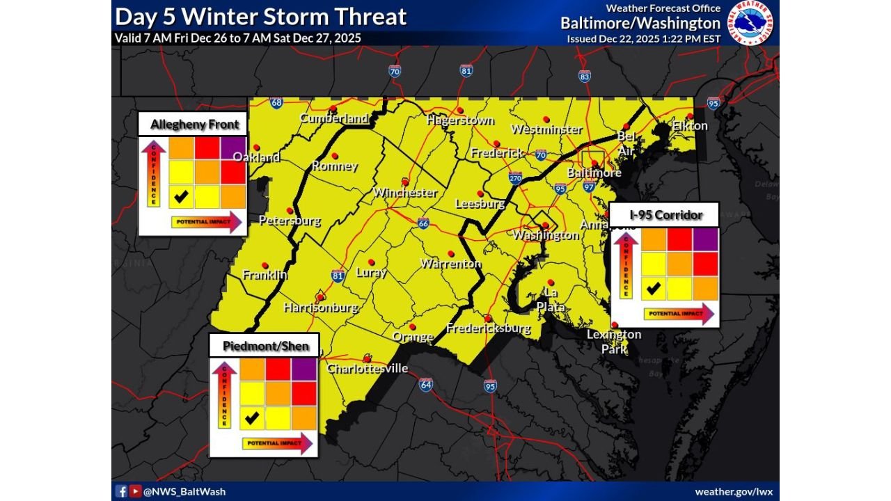
Areas Most at Risk Across the Mid-Atlantic
Based on the latest Day 5 Winter Storm Threat outlook, a broad swath of the Mid-Atlantic is highlighted for potential winter impacts, including:
- Northern and central Virginia, including the Piedmont and Shenandoah Valley
- Much of Maryland, from western counties to the I-95 corridor
- Washington, D.C. metro area, including nearby suburbs
- Portions of eastern West Virginia
The outlook places much of the region in a yellow-shaded risk area, signaling enough confidence for impactful weather but with remaining uncertainty on exact precipitation type and timing.
Why Freezing Rain Is a Bigger Concern Than Snow
Unlike snow, freezing rain forms when warm air aloft overrides colder surface air, allowing rain to fall and then freeze on contact. This setup can lead to:
- Invisible ice on roadways and bridges
- Downed tree limbs and power lines if ice thickens
- Travel disruptions even with minimal accumulation
“If this threat were to occur, slick roads and travel disruptions will be possible,” forecasters warned.
Even a glaze of ice can make untreated roads dangerous, especially overnight and during the early morning hours.
Timing: When Conditions Could Deteriorate
Current guidance places the highest risk window between:
- Friday morning, December 26
- Early Saturday morning, December 27
Temperatures during this period will be critical. Small shifts of just a degree or two will determine whether locations see plain rain, sleet, or freezing rain.
What Residents Should Do Now
While confidence is still moderate, officials urge residents to prepare early, especially those who must travel.
Recommended steps include:
- Monitoring updated forecasts through mid-week
- Planning for possible delays or icy commutes
- Avoiding unnecessary overnight travel if icing develops
- Ensuring vehicles are winter-ready
“Stay tuned and just be ready,” forecasters emphasized, noting that confidence will increase as the event draws closer.
Forecast Confidence Still Evolving
Meteorologists caution that this is still a Day 5 outlook, meaning details can and likely will change. However, the consistent colder trend across multiple model runs increases confidence that some form of wintry precipitation is possible.
Updates, watches, or advisories may be issued later this week as the system becomes better resolved.
Stay connected with WaldronNews.com for continued updates as this developing Mid-Atlantic winter threat comes into sharper focus. What are you seeing where you live — rain, cold air, or early icing concerns? Share your local conditions and thoughts with us.