
Virginia, Maryland, North Carolina and Washington DC Could See Rare Moderate Risk Severe Storms Monday With Tornadoes and Destructive Winds Possible
UNITED STATES — Meteorologists are warning that a volatile severe weather environment could develop along the East Coast on Monday, March 16, raising concerns that parts of Virginia, Maryland, North Carolina and Washington DC may face a significant severe storm outbreak.
Forecast analysis suggests that a powerful storm system moving through the eastern United States could create conditions favorable for multiple severe thunderstorms, with the potential for damaging winds and several tornadoes.
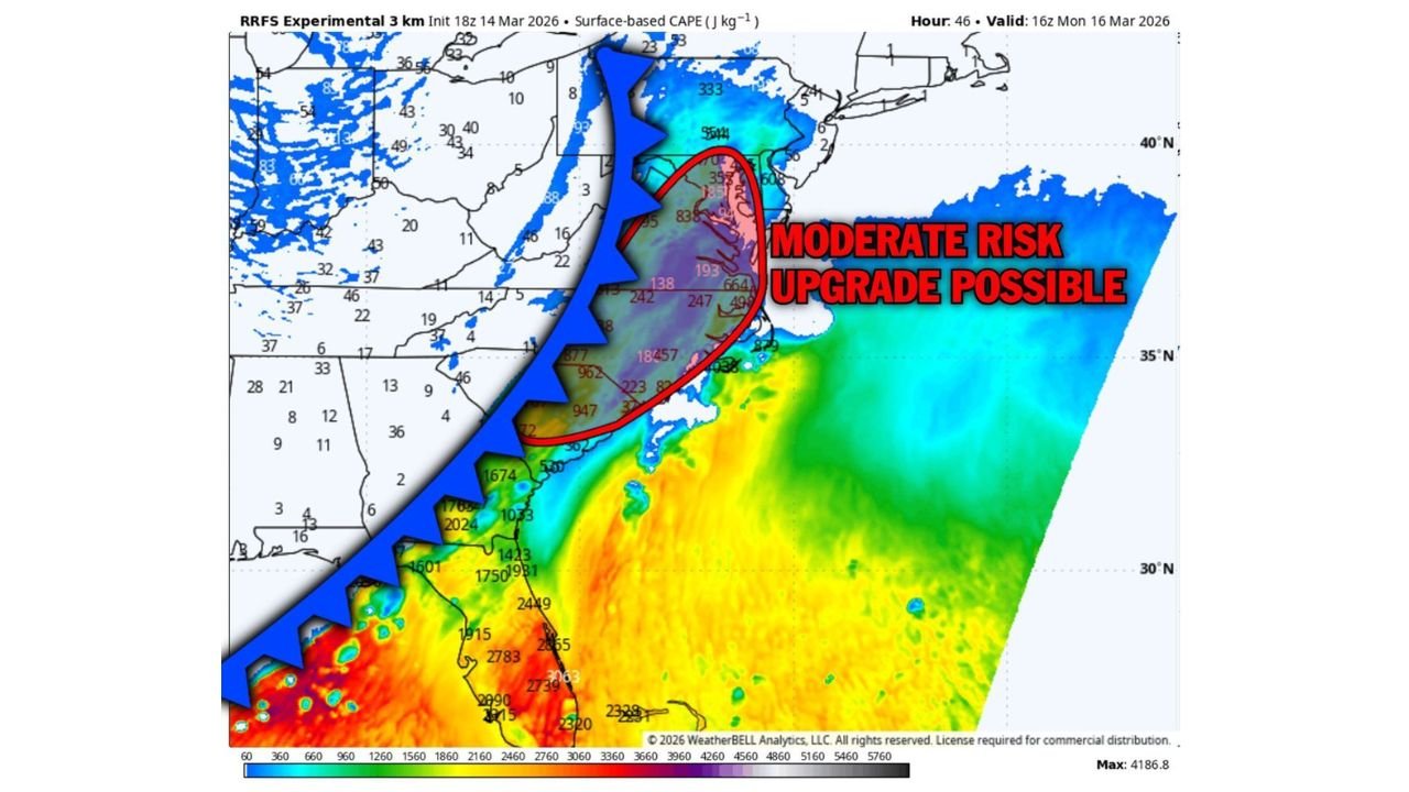
Forecasters are even considering upgrading portions of the Mid-Atlantic to a Level 4 out of 5 “Moderate Risk,” a designation that typically signals the potential for widespread or intense severe weather.
Instability and Wind Shear Could Fuel Dangerous Storms
Weather models indicate that atmospheric instability is expected to increase rapidly ahead of an approaching cold front, particularly across the Mid-Atlantic region.
This instability — measured by CAPE (Convective Available Potential Energy) — is forecast to build across:
- Virginia
- Maryland
- North Carolina
- Washington DC
- Portions of Pennsylvania and Delaware
When this unstable air overlaps with strong wind shear and favorable upper-level winds, meteorologists say the atmosphere can become primed for organized supercell thunderstorms.
Supercells are the type of storms most capable of producing tornadoes and widespread wind damage.
Corridor of Greatest Concern Across the Mid-Atlantic
Forecast models highlight a corridor where the ingredients for severe weather may align most strongly.
The area of greatest concern includes:
- Richmond, Virginia
- Washington DC
- Baltimore, Maryland
- Norfolk, Virginia
- Raleigh, North Carolina
This region sits in the zone where warm, moist air from the Atlantic and Gulf interacts with strong winds in the atmosphere ahead of the advancing cold front.
Such conditions can allow thunderstorms to intensify rapidly and maintain rotation.
Multiple Hazards Possible
If storms develop as expected Monday, the main threats across the Mid-Atlantic could include:
- Tornadoes, some potentially strong
- Widespread damaging wind gusts
- Large hail in stronger storms
- Heavy rainfall and lightning
Powerful wind gusts from fast-moving storm lines could cause tree damage and scattered power outages, while isolated rotating storms could produce tornadoes.
Cold Front Expected to Trigger Storm Development
The severe weather threat is linked to a strong cold front sweeping eastward across the eastern United States.
As the front moves through the region Monday, it will force warm, unstable air upward, helping thunderstorms to form.
At the same time, strong winds higher in the atmosphere will allow storms to organize and intensify, increasing the risk of severe weather.
Timing of the Severe Weather Threat
Early projections suggest storms could develop during Monday afternoon and continue into the evening hours.
The most active period may occur late afternoon through nighttime, when the strongest storms track across Virginia, Maryland and North Carolina.
Because storms may continue after sunset, some communities could face dangerous nighttime severe weather conditions.
Residents Encouraged to Stay Weather Aware
Officials are encouraging residents across the Mid-Atlantic to monitor forecasts closely and prepare for possible severe weather Monday.
Safety recommendations include:
- Enabling emergency weather alerts
- Identifying safe shelter locations in homes
- Monitoring local weather updates
- Preparing for possible power outages
Severe weather setups can evolve quickly, and the exact placement of the strongest storms may change as new data becomes available.
Meteorologists Watching for Potential Upgrade
As new forecast data arrives, meteorologists will continue evaluating whether conditions warrant a Moderate Risk upgrade for parts of the East Coast.
If the upgrade occurs, it would indicate increasing confidence in a significant severe weather event affecting portions of Virginia, Maryland, North Carolina and Washington DC.
Stay with WaldronNews for continuing updates as forecasters track this developing severe weather threat across the Mid-Atlantic and East Coast.