
Virginia, Maryland, Pennsylvania, North Carolina Brace for Possible Major Snow-to-Ice Winter Storm This Weekend
MID-ATLANTIC — A developing winter storm setup is drawing close attention across Virginia, Maryland, Pennsylvania, North Carolina, and the Washington, D.C. region, where forecast data shows a growing risk of a high-impact snow and ice event from late Friday through Sunday, with lingering effects possibly into Monday.
While the exact track and precipitation type are still being refined, multiple model signals now agree on a significant winter weather threat, one that could rival some of the more memorable Mid-Atlantic storms of the past decade.
Why This Setup Has Meteorologists Concerned
Current guidance shows a strong Arctic high pressure system locked in across the northern Mid-Atlantic, supplying deep cold air at the surface. At the same time, a powerful southern jet stream is forecast to transport warm, moisture-rich air over the top of that cold dome.
This classic setup creates a dangerous overlap:
- Cold air trapped near the ground
- Warm air aloft riding northward
- Prolonged precipitation overrunning the cold surface
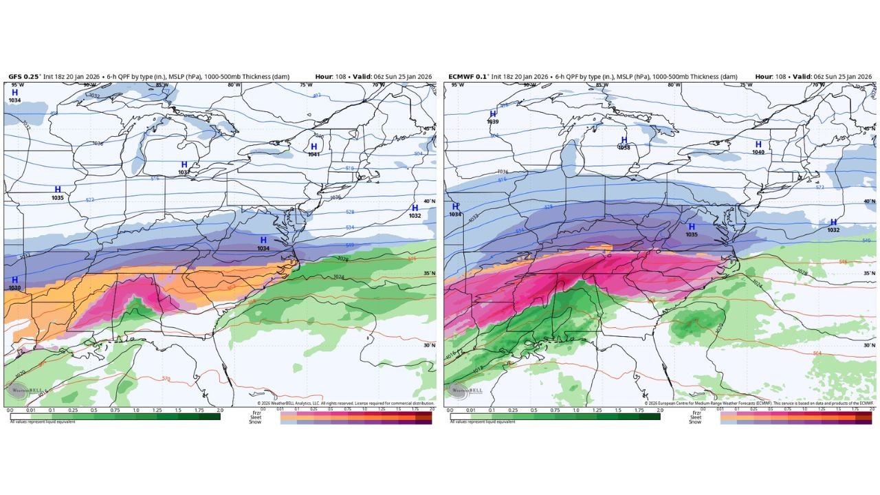
When this happens, snow can quickly transition to sleet or freezing rain, especially across Virginia, Maryland, and central North Carolina — areas historically vulnerable to ice storms.
Snowfall Probabilities Show a Real Risk of a Major Event
European ensemble modeling, which runs the storm scenario dozens of times, shows notable probabilities for heavy snow totals across parts of the region:
- 30–40% chance of 12 inches or more near and just south of Washington, D.C.
- 40–60% probabilities extending through parts of Virginia into central Maryland
- Lower but still meaningful odds spreading northward into southern Pennsylvania
These probabilities alone do not guarantee outcomes, but numbers this high several days out are uncommon and strongly suggest the atmosphere is capable of producing a high-end event.
Snow or Ice? That’s the Critical Question
One of the biggest uncertainties right now is how long snow can hold on before warmer air aloft wins out.
Current projections suggest:
- Snow is favored early, especially Friday night into part of Saturday
- A transition zone may develop Saturday night or Sunday
- Sleet and freezing rain become increasingly possible from southern Virginia into North Carolina
Even small changes in storm track or temperature profiles could dramatically shift impacts from heavy snow to widespread ice accumulation, which poses a greater threat to power infrastructure and travel safety.
Timing: What to Watch Closely
- Friday: Light precipitation may begin in parts of Virginia and North Carolina
- Saturday: Main storm intensifies; snow likely expands north and east
- Saturday Night – Sunday: Highest risk window for heavy snow and/or ice
- Monday: Lingering precipitation and hazardous travel conditions possible
Because this system may be slow-moving, impacts could last longer than a typical winter storm.
Potential Impacts Across the Region
If current trends hold, communities across the Mid-Atlantic should prepare for:
- Hazardous or impossible travel
- Power outages, especially in ice-prone areas
- School and government closures
- Flight disruptions at major regional airports
- Extended recovery time in hard-hit areas
Ice accumulation, even more than snow totals, will determine how disruptive this storm becomes.
Important Reminder: Forecasts Will Change
This storm is still several days away, and details will evolve as higher-resolution data becomes available. The northern edge of the storm remains especially uncertain, meaning impacts in Pennsylvania could still shift north or south.
That said, the overall signal is strong enough that this setup should be taken seriously now, not at the last minute.
What You Should Do Now
If you live in Virginia, Maryland, Pennsylvania, North Carolina, or the D.C. metro, this is the time to:
- Review winter emergency plans
- Prepare for possible power outages
- Monitor forecast updates daily
- Avoid unnecessary travel plans this weekend
We’ll continue tracking this system closely and provide updates as confidence increases.
Have you experienced a major Mid-Atlantic winter storm before? Share how you prepare — and stay connected with Waldron News for the latest updates as this forecast develops.