
Virginia, North Carolina, Maryland and Washington DC Could Face Rare Level 4 Severe Weather Risk Monday as Major Storm Threat Targets Mid-Atlantic
UNITED STATES — A potentially significant severe weather event is developing for the Mid-Atlantic region on Monday, March 16, with forecasters warning that parts of Virginia, North Carolina, Maryland and Washington DC could experience a dangerous outbreak of severe thunderstorms.
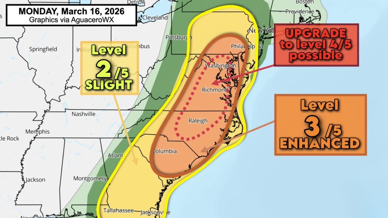
Meteorologists say the Storm Prediction Center (SPC) is already highlighting a Level 3 out of 5 “Enhanced Risk” across a large portion of the region, while discussions are underway about the possibility of upgrading some areas to a Level 4 “Moderate Risk.”
If such an upgrade occurs, it would mark one of the few higher-end severe weather outlooks issued for the Mid-Atlantic in recent years.
Enhanced Risk Zone Stretches Across the Mid-Atlantic
Current forecast outlooks place a large portion of the Mid-Atlantic and Southeast coastline under an Enhanced Risk, including parts of:
- Virginia
- North Carolina
- Maryland
- Washington DC
- Portions of South Carolina and West Virginia
Major population centers within or near the risk area include:
- Washington DC
- Richmond, Virginia
- Norfolk, Virginia
- Raleigh, North Carolina
- Philadelphia, Pennsylvania
These areas could see strong thunderstorms capable of producing damaging winds and tornadoes as the storm system intensifies Monday.
Level 4 Risk Upgrade Being Considered
Forecast discussions indicate the SPC may consider upgrading parts of the Mid-Atlantic to a Level 4 risk, which represents a higher probability of widespread severe weather.
Such outlooks are relatively rare for the region, occurring only a few times per decade on average.
The last comparable high-end outlook for the Mid-Atlantic occurred on August 7, 2023, with another notable event occurring on April 19, 2023.
Because these outlook levels are issued only when forecasters have increasing confidence in a significant severe weather setup, the possibility of an upgrade is drawing attention among meteorologists.
Damaging Winds and Tornadoes Possible
If the system develops as forecast, the primary hazards across the Mid-Atlantic could include:
- Widespread damaging wind gusts
- Possible tornadoes
- Heavy rainfall and thunderstorms
Strong wind fields in the atmosphere combined with warm, unstable air could allow storms to organize into fast-moving lines or rotating supercells.
These types of storms are capable of producing widespread wind damage and isolated tornadoes, particularly during peak afternoon and evening hours.
Storm System Expected to Move Northeast
The severe weather setup is tied to a strong low-pressure system tracking northeast across the eastern United States.
As the system moves toward the Great Lakes and Northeast, a powerful cold front will sweep through the Southeast and Mid-Atlantic, triggering thunderstorms along the boundary.
Warm, humid air flowing northward from the Gulf of Mexico will provide fuel for storms, while strong upper-level winds create favorable conditions for severe weather development.
Storm Timing Expected Monday Afternoon and Evening
Current forecasts suggest that thunderstorms may begin developing Monday afternoon across parts of the Southeast, before expanding into the Mid-Atlantic during the late afternoon and evening hours.
The most active severe weather period could occur during the late afternoon through nighttime hours, when storms move across Virginia, North Carolina and surrounding states.
Because storms may continue after sunset, some communities could face dangerous nighttime severe weather conditions.
Residents Urged to Monitor Forecast Updates
Officials across the Mid-Atlantic region are encouraging residents to closely monitor weather updates as the storm system approaches.
Preparation steps include:
- Enabling emergency alerts on smartphones
- Monitoring weather forecasts throughout Monday
- Identifying safe shelter areas in homes
- Preparing for possible power outages
Severe weather events can evolve rapidly, and the exact placement of the strongest storms may still change as newer forecast data becomes available.
Forecast Confidence Expected to Increase Soon
Meteorologists expect forecast confidence to improve as the event approaches and new weather model data becomes available.
However, early indications suggest parts of Virginia, North Carolina, Maryland and Washington DC could face one of the more significant severe weather threats seen in the Mid-Atlantic in recent years.
Stay with WaldronNews for continuing updates as forecasters monitor this developing severe weather threat across the Mid-Atlantic region.