
Virginia Snowfall Patterns Shift Dramatically This Season as NOAA Data Shows Major Storm Tracks Avoiding the Mid-Atlantic
VIRGINIA — New national snowfall data released by NOAA highlights a striking shift in winter storm behavior across the United States, showing that while parts of the Midwest, Great Lakes and Northeast have received substantial snowfall so far this season, much of Virginia and the broader Mid-Atlantic corridor remain noticeably snow-starved. Meteorologists say the emerging pattern reflects a clash of storm tracks — often described as “either/or” — that has repeatedly favored northern and interior regions while bypassing Virginia’s traditional winter “sweet spots.”
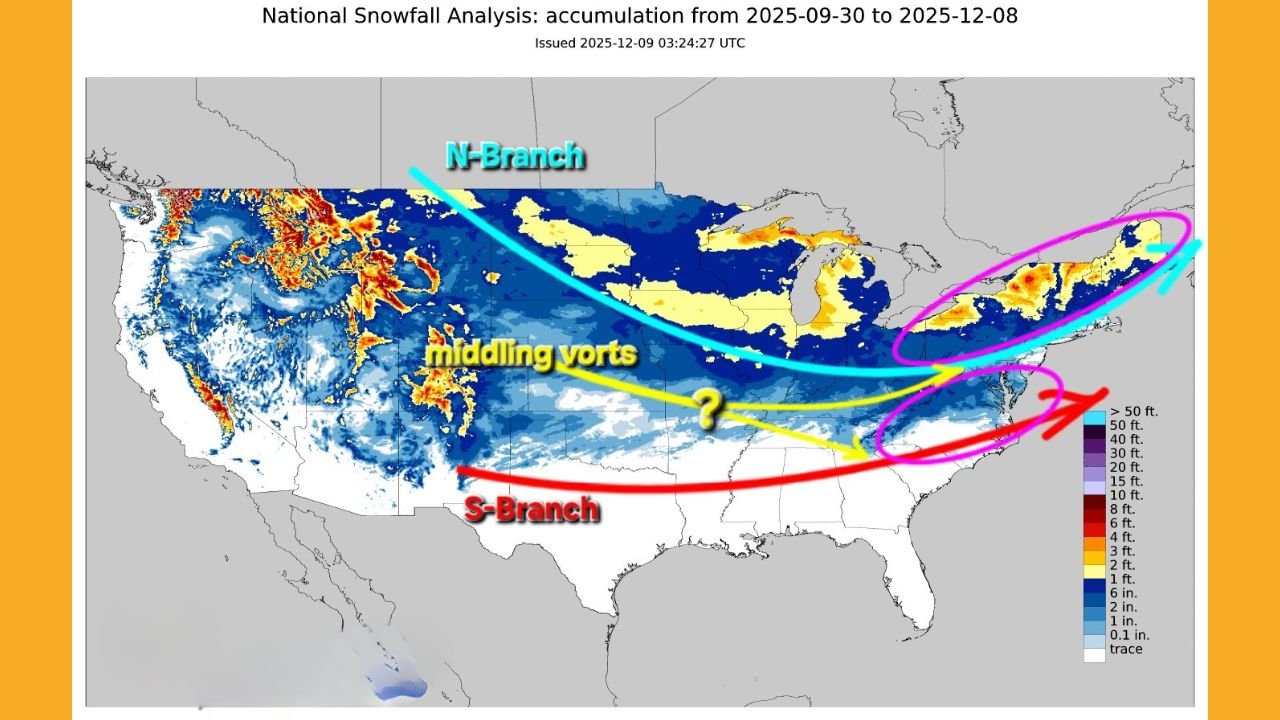
Northern Storm Branch Dominates Early-Season Activity
This season’s snowfall map shows the N-Branch, a strong northern storm track, sending consistent waves of snow across the Pacific Northwest, Northern Rockies, Upper Midwest, and interior New England.
These systems have delivered multiple feet of snow in states such as Washington, Idaho, Wisconsin, Michigan, Vermont, and Maine, reinforcing a classic La Niña–style pattern where northern energy remains dominant.
Virginia, however, sits south of this active boundary, leaving much of the state with little to no measurable snow accumulation through early December.
Mid-Level Systems Still Too Weak to Reach Virginia
NOAA’s analysis also shows a secondary belt of disturbances — labeled “middling vorts” — sweeping across the central U.S. These systems have produced modest snow events across:
- Iowa
- Nebraska
- Kansas
- Northern Missouri
- Southern Great Lakes
But meteorologists note that these mid-level disturbances frequently weaken before reaching the Mid-Atlantic, either dissipating over the Appalachians or transferring energy offshore too late to affect Virginia.
This pattern has created a persistent snowfall gap zone stretching from the Ohio Valley into parts of the Mid-Atlantic, including Virginia.
Southern Storm Branch Remains Active but Too Far South
A third storm track, identified as the S-Branch, has been more active across the Deep South than in recent years — but continues to pass below Virginia’s latitude. This track has produced early-season winter precipitation in:
- Texas Panhandle
- Oklahoma
- Arkansas
- Northern Mississippi
- Tennessee
Despite this, forecasters emphasize that very few of these systems have the cold air required to push snow into Virginia.
Historically, Virginia’s most significant snowstorms occur when the northern and southern branches “phase”, forming powerful coastal systems along the 40/70 benchmark (40°N latitude, 70°W longitude). But meteorologists say this alignment typically happens only once every 6–7 years, and back-to-back favorable years are rare.
Virginia’s Coastal ‘Sweet Spot’ Has Been Quiet — and Experts Say That’s Normal
Experts point out that while winter enthusiasts may feel Virginia is overdue, the lack of activity is typical.
Meteorologists note:
- The Virginia Capes-to-40/70 corridor has been inactive this season.
- Major D.C.-to-Boston snowstorms are exceptions, not annual events.
- Several promising systems this year have shifted north or south, missing Virginia entirely.
The setup so far has reinforced the long-known winter reality for the Commonwealth:
Virginia sits at the intersection of competing storm tracks — and small shifts often determine whether the state sees a major snowstorm or none at all.
What the Latest NOAA Analysis Suggests About the Rest of Winter
While the early-season pattern has kept most significant snowfall away from Virginia, several key signals remain worth watching:
- Persistent northern energy could eventually dip farther south.
- The southern jet has been active — a potential precursor to future East Coast systems.
- The “middling vorts” corridor suggests storm development potential if colder Arctic air penetrates deeper into the Mid-Atlantic.
Meteorologists caution that a single well-timed phasing event can dramatically alter Virginia’s seasonal snowfall totals.
For now, however, the evidence points to continued snowfall scarcity across much of the state unless storm tracks begin to converge.
Winter patterns can shift rapidly — especially in regions like Virginia where storm tracks often collide.
Stay updated with daily regional forecasts, storm alerts, and expert analysis by following WaldronNews.com for the latest winter weather developments across the Commonwealth.