
Warm Front from Eastern Iowa into Illinois and Indiana Sets Stage for Evening Severe Storms — But Mixing and Elevated Development Could Limit Long-Track Tornado Threat
MIDWEST — A potentially significant severe weather setup is taking shape from eastern Iowa into Illinois and Indiana, but new high-resolution model data highlights both the strength of the environment and the uncertainties that could determine whether tornado potential fully materializes.
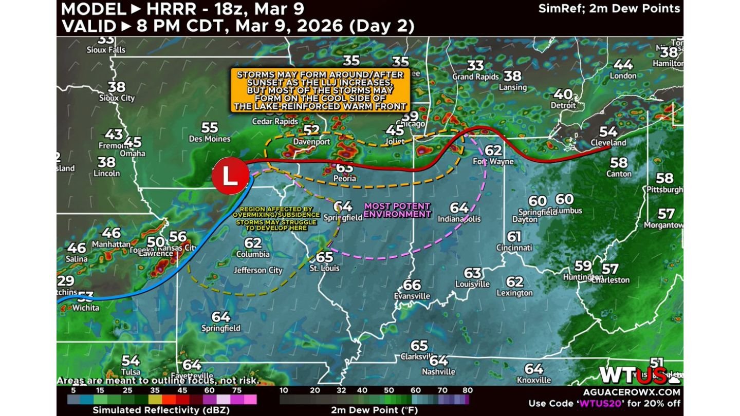
The 18z HRRR model run shows a very potent atmosphere developing near a warm front draped from eastern Iowa across northern Illinois and into northern Indiana late this afternoon and evening. Dew points in the lower to mid 60s surge northward into central Illinois and Indiana, signaling rich low-level moisture in place ahead of an approaching system.
However, several complicating factors may prevent a more widespread, long-tracked tornado scenario.
Most Potent Environment: Central Illinois into Central Indiana
The most favorable overlap of instability and wind shear appears from:
- Peoria
- Springfield, Illinois
- Bloomington
- Indianapolis
- Lafayette
- Fort Wayne
This corridor sits near and just south of the surface warm front, where low-level moisture and stronger wind profiles are expected to coexist.
Any storm that forms and remains rooted on the warm side of the boundary would be capable of producing a strong tornado. The wind field strengthens into the evening as the low-level jet intensifies around sunset, increasing storm organization potential.
Complication #1: Mixing Across Missouri and Illinois
Across parts of Missouri and western Illinois, temperatures may surge into the lower to mid 80s. While that may sound favorable for severe storms, excessive surface heating can cause low-level moisture to mix out.
If dew points drop due to mixing:
- Instability may become less favorable
- Storm coverage could be more limited
- Some areas may struggle to initiate storms altogether
Model guidance highlights a region near central Missouri and parts of western Illinois where subsidence and mixing may suppress storm development.
Complication #2: Elevated Storms North of the Warm Front
As evening approaches and the low-level jet increases, storms are expected to develop near and north of the warm front — particularly from near Davenport toward Joliet and into northern Indiana.
However, many of these storms may form on the cool side of the boundary. When storms become elevated, they are less likely to produce tornadoes but can become efficient hail producers.
Large hail up to 2 inches is possible with elevated supercells north of the boundary.
This suggests a scenario where:
- Northern Illinois and eastern Iowa face a greater hail risk
- Central Illinois into Indiana faces the higher tornado potential
Key Cities to Watch
Areas of particular concern this evening include:
- Davenport
- Peoria
- Springfield (IL)
- Bloomington
- Indianapolis
- Lafayette
- Fort Wayne
Farther east into Dayton, Cincinnati, and Louisville, storms may weaken or become more scattered, though gusty winds and hail cannot be ruled out.
Timing and Evolution
Storms may begin to form around or shortly after sunset as the low-level jet strengthens. The environment becomes increasingly supportive of organized storms during the early to mid-evening hours.
The exact placement of the warm front will be critical. A shift of even 20–40 miles north or south could significantly alter which communities see the highest tornado threat versus primarily hail.
Bottom Line
The environment is undeniably potent across parts of eastern Iowa, Illinois, and Indiana. But storm mode, boundary placement, and moisture retention will determine whether this becomes:
- A hail-dominant elevated event north of the boundary
- A more serious tornado-producing setup along the warm side
Residents across central Illinois and Indiana should remain alert through the evening hours, especially near the warm front zone.
WaldronNews.com will continue tracking updates as this complex severe weather setup unfolds across the Midwest.