
Warming Trend Targets New York, Pennsylvania, Ohio and New England as Ridge Builds Across Eastern U.S., Bringing First Stretch of 40s in Over a Month
UNITED STATES — After weeks of colder-than-average conditions, a noticeable warming trend is poised to develop across the Eastern United States next week, with several Northeast and Mid-Atlantic states expected to see their first consistent above-average highs in roughly five weeks.
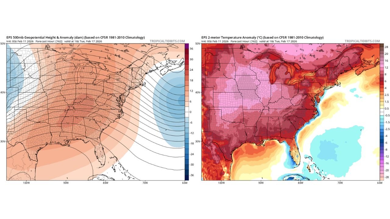
Forecast model guidance shows a broad upper-level ridge expanding across much of the eastern half of the country by Tuesday, February 17, signaling a shift toward milder air across states from the Midwest to New England.
Ridge Expands Across Midwest and East
The 500mb geopotential height forecast indicates positive height anomalies spreading over:
- Ohio
- Pennsylvania
- New York
- New Jersey
- Massachusetts
- Connecticut
- Maryland
- Virginia
- West Virginia
- Michigan
- Indiana
- Illinois
This upper-level pattern favors rising heights and sinking air, a setup commonly associated with calmer and milder surface conditions.
While the ridge does not fully lock into the Northeast, low-level flow becomes favorable for warmer air to push northward from the southern states into the Mid-Atlantic and New England.
Temperature Anomalies Show Widespread Above-Normal Warmth
The 2-meter temperature anomaly forecast highlights widespread positive departures from average across nearly the entire eastern half of the country.
Areas expected to see the strongest warm anomalies include:
- Ohio Valley
- Pennsylvania
- Upstate and Western New York
- New England
- Mid-Atlantic states
- Michigan and the Great Lakes region
Anomalies of several degrees above normal are projected, especially across the Great Lakes and interior Northeast.
Even across the Southeast — including Georgia, Alabama, South Carolina, and North Carolina — temperatures are forecast to run above climatological averages.
Northeast Likely to See Multiple Days in the 40s
For much of the Northeast, this marks a significant shift. After extended stretches of colder air and below-normal highs, many locations are expected to see:
- Several days with highs in the 40s
- Temperatures running above mid-February averages
- A break from persistent Arctic intrusions
While the warmup may not be dramatic enough to produce 50s widespread in every state, it represents the first sustained moderation in about a month.
Coastal Influence and Offshore Trough
The model also shows a trough positioned offshore of the East Coast, particularly east of New England and the Mid-Atlantic. This offshore feature helps prevent colder air from diving directly into the region while allowing milder south-to-southwest flow to develop inland.
The result is a balanced pattern — not a full-blown spring surge, but a meaningful break from prolonged cold.
What This Means for the Region
Residents across:
- New York
- Pennsylvania
- Ohio
- New Jersey
- Massachusetts
- Connecticut
- Maryland
- Virginia
- Michigan
- Illinois
- Indiana
can expect a noticeable moderation compared to recent weeks.
Snow and ice concerns may temporarily diminish in many interior areas, and daytime conditions should feel more seasonable to mild.
This warming stretch does not signal the end of winter, but it does mark the first organized period of above-average temperatures in nearly five weeks across the Northeast and surrounding states.
Waldronnews.com will continue monitoring whether this ridge strengthens further or if colder air attempts to return later in the month.