
Washington and Oregon Under 170+ Knot Jet Stream as Hawaiian Airlines Tokyo-to-Seattle Flight Hits 720 MPH Ground Speed Riding Powerful Pacific Jet
PACIFIC NORTHWEST — A powerful upper-level jet stream roaring across the North Pacific helped propel a Hawaiian Airlines flight from Tokyo to Seattle to a staggering 720 mph ground speed, as atmospheric data shows winds exceeding 170 knots aimed directly at Washington and Oregon.
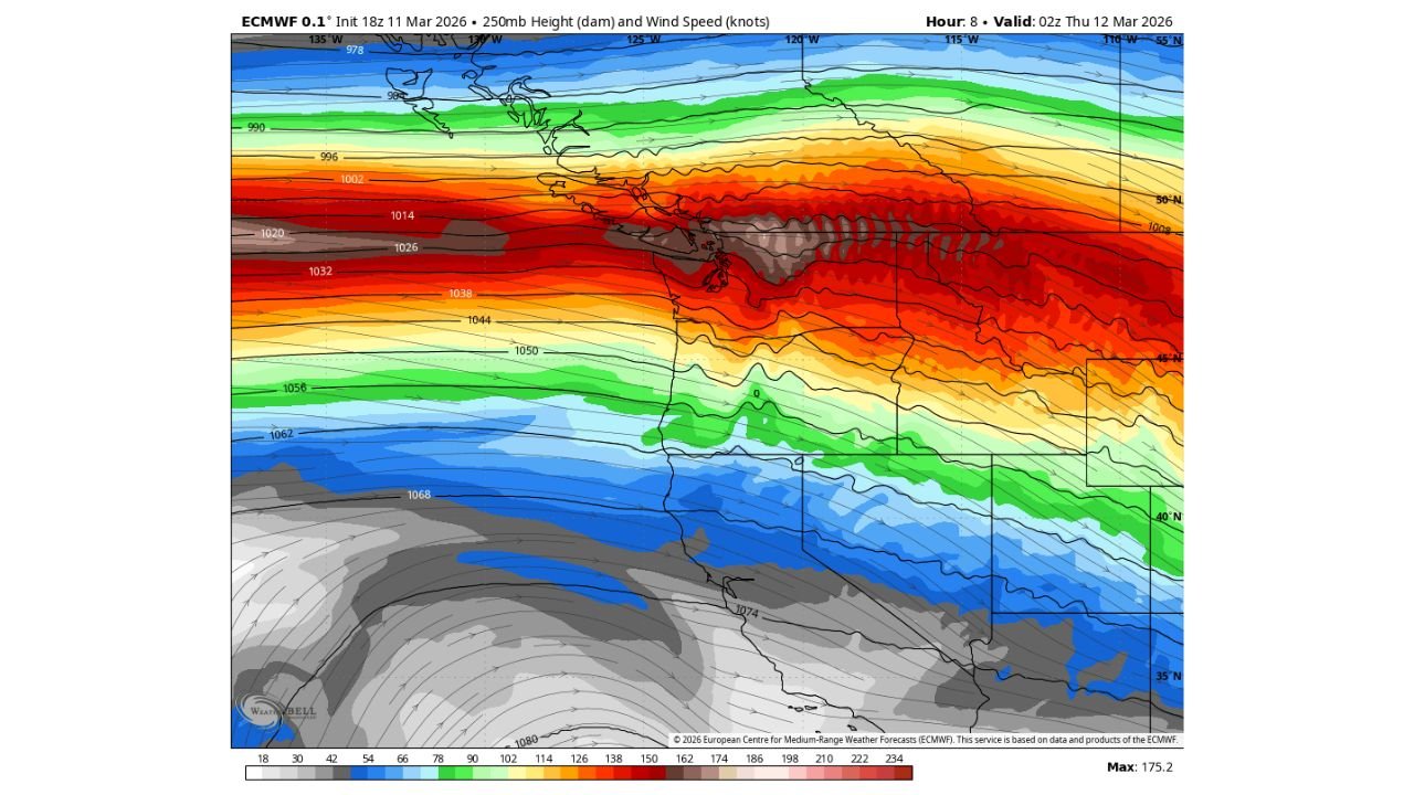
The remarkable flight speed coincided with an intense jet streak positioned just offshore of the Pacific Northwest, highlighted by deep red shading on the latest ECMWF 250mb wind analysis.
Jet Stream Exceeding 170 Knots Over the Pacific
Upper-level data valid early Thursday morning shows:
- A concentrated jet core stretching from the western Pacific toward British Columbia
- Wind speeds peaking near 175 knots (around 200+ mph) at the 250mb level
- The strongest axis aimed toward Washington State and southern British Columbia
This intense ribbon of air — several miles above the surface — acts like a conveyor belt for eastbound aircraft, dramatically boosting ground speed when flights align with its core.
720 MPH Ground Speed Over the Pacific
Ground speed differs from airspeed. While aircraft cruise at typical airspeeds near 500–560 mph, a strong tailwind can significantly increase how fast the aircraft moves relative to the ground.
With upper-level winds exceeding 170 knots:
- The Hawaiian Airlines Tokyo-to-Seattle flight tapped directly into the jet core
- Ground speed briefly reached approximately 720 mph
- The aircraft effectively rode one of the strongest atmospheric highways currently active over the Pacific
Such speeds are uncommon but not unprecedented when extreme jet streaks intensify across the North Pacific during late winter and early spring.
Why the Pacific Northwest Is Seeing Such a Strong Jet
The ECMWF map shows tightly packed height contours and intense wind shading across:
- Washington
- Oregon
- Southern British Columbia
This setup indicates a powerful temperature gradient across the North Pacific, which strengthens the upper-level wind field.
When the jet stream intensifies this dramatically:
- Eastbound flights benefit from major tailwinds
- Westbound flights often face strong headwinds and longer travel times
- Weather systems can rapidly strengthen along the jet corridor
Implications Beyond Aviation
A jet streak of this magnitude can also:
- Enhance storm development near the Pacific Northwest
- Increase precipitation intensity
- Drive strong surface winds in coastal regions
While the 720 mph flight captured attention, the broader atmospheric pattern reflects a highly energized Pacific flow aimed at the West Coast.
A Rare but Powerful Atmospheric Setup
Jet streaks exceeding 170 knots are not everyday occurrences, especially when positioned so directly toward Washington and Oregon.
The alignment of a long Pacific trajectory with a powerful upper-level wind maximum created near-ideal conditions for eastbound trans-Pacific flights to experience exceptional ground speeds.
Stay with WaldronNews.com for continued coverage of major jet stream developments and their impacts on weather and travel across the Pacific Northwest.