
Washington Atmospheric River to Deliver Dangerous Snowstorm on Mount Rainier, With Over 110 Inches Expected at 14,000 Feet
WASHINGTON — A powerful atmospheric river, rated at Category 4/5, is forecast to slam into the Pacific Northwest this week, bringing exceptionally high snow levels across the region — but on Mount Rainier, the story becomes far more extreme. Forecast models show that elevations near 14,000 feet could receive more than 110 inches of snow by Friday, creating highly dangerous mountain conditions as warm, moisture-laden Pacific air collides with the peak’s frigid upper atmosphere.
A Major Atmospheric River Taking Aim at the Pacific Northwest
Meteorologists report that this approaching atmospheric river ranks among the strongest so far this season. While lower elevations in western Washington and Oregon will see heavy rainfall and rising snow levels, the upper mountain ranges — especially Mount Rainier — are expected to be buried under tremendous snowfall.
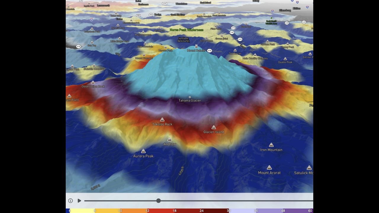
The 3D precipitation modeling image illustrates how precipitation intensity increases sharply with elevation. Surrounding lower peaks will receive mixed rain and snow, but Rainier’s summit sits high enough above the warming influence of the atmospheric river to convert the incoming moisture entirely into snow.
Why Mount Rainier’s Snowfall Will Be Extreme
The simulation imagery shows deep blue and purple shading wrapped tightly around the summit cone, indicating snowfall totals surpassing 100 inches. Terrain-driven uplift will enhance precipitation rates as atmospheric river moisture slams into the 14,000-foot elevation band.
Key forecast indicators:
- 110+ inches of summit snow possible by Friday
- Lower elevation ranges will see mostly rain due to unusually high freezing levels
- Slopes between 8,000–12,000 feet will receive a mixture of wet snow and heavy slush
- Atmospheric river plume moisture extends hundreds of miles offshore
Officials say the extreme snowfall at high elevations could greatly increase avalanche danger on and around Mount Rainier for days following the storm.
Regional Impacts Across Washington State
While the most eye-catching totals belong to Rainier itself, the broader Pacific Northwest will face widespread hazards:
- Western Washington urban areas: Flooding risk from heavy rain
- Cascade foothills: Rapid runoff, landslide potential
- Mid-elevation passes: Heavy wet snow making travel dangerous
- Higher alpine zones: Blinding snow, whiteout conditions, avalanche risk
Forecasters emphasize that this atmospheric river is both unusually strong and carrying a deep moisture plume, significantly increasing precipitation totals across the region.
What Comes Next
Forecast confidence remains high that snowfall in the upper alpine zone will exceed 100 inches and may even surpass early estimates if moisture continues to surge inland. The National Weather Service expects multiple storm waves to follow behind this one as the Pacific jet stream remains active.
Mount Rainier National Park officials are urging extreme caution, advising climbers and backcountry travelers to avoid high-elevation terrain entirely until conditions stabilize.
Severe weather can change rapidly across the Pacific Northwest. Stay updated with the latest forecasts, storm alerts, and safety information right here at WaldronNews.com, where we continue to track every development.