
Washington, D.C. Hit by Shocking 31-Degree Temperature Plunge — Fourth Cold Front in Two and a Half Weeks Hammers the Region
WASHINGTON, D.C. — A powerful cold front swept through Washington, D.C. on Friday, sending temperatures crashing from 80°F at 4 p.m. Thursday all the way down to just 49°F at 4 p.m. Friday — a brutal 31-degree drop in just 24 hours. This marks the fourth major cold front to batter the region in the past two and a half weeks, with tonight’s lows expected to fall into the upper 20s and lower 30s.
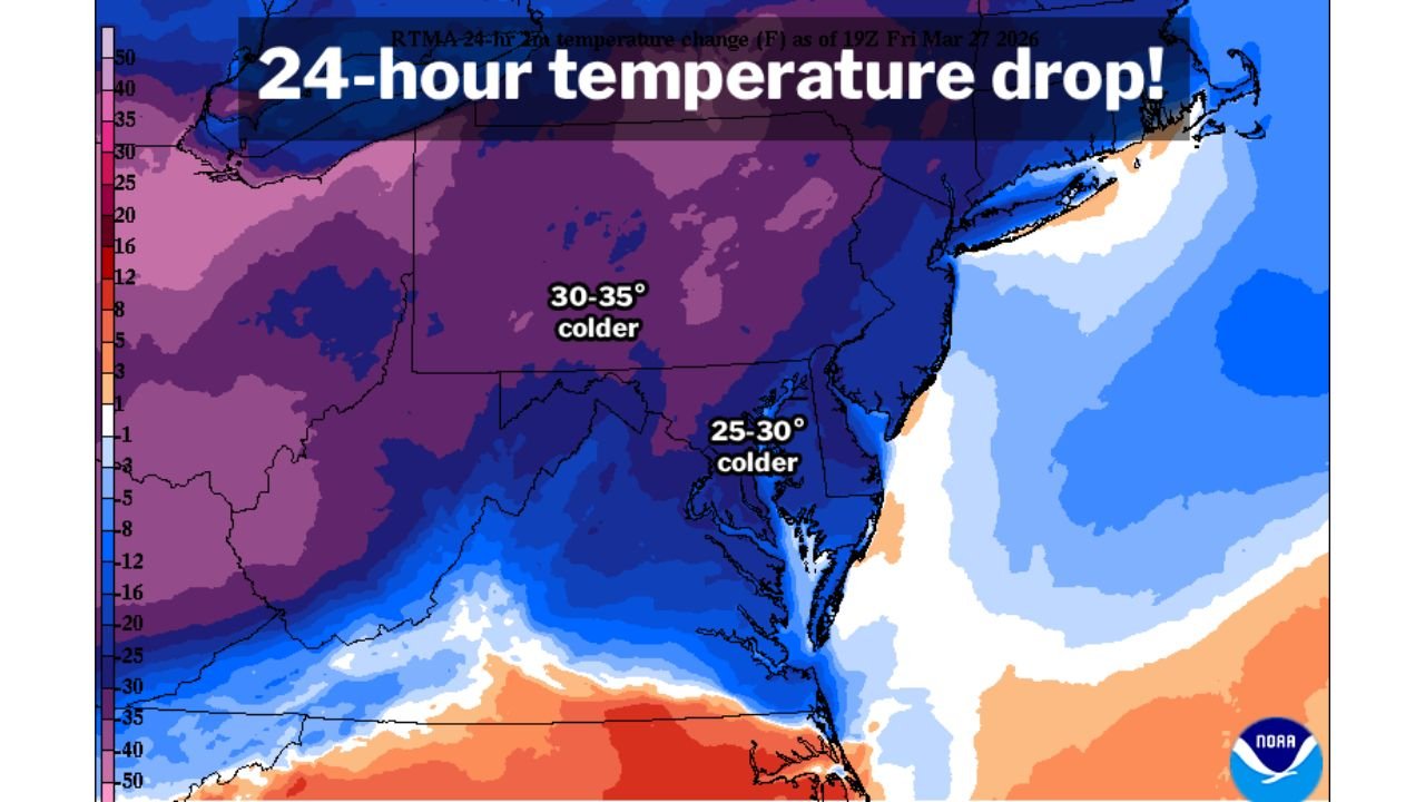
The broader mid-Atlantic region is feeling the full force of this Arctic intrusion. According to NOAA’s Real-Time Mesoscale Analysis (RTMA) data as of Friday, interior portions of the mid-Atlantic recorded temperature drops of 30 to 35 degrees in 24 hours, while the Washington, D.C. metro corridor saw drops in the 25 to 30-degree range.
Cities and States in the Impacted Zone
The 24-hour temperature collapse is widespread across the mid-Atlantic:
- Washington, D.C.: Temperature dropped from 80°F to 49°F in a single afternoon
- Mid-Atlantic interior: Areas recording 30 to 35 degrees colder than 24 hours prior
- D.C. metro corridor: Widespread 25 to 30-degree temperature drop
- Reagan National Airport: Ground zero for the region’s most dramatic temperature swings this season
The cold is deepest across the interior mid-Atlantic, gradually tapering toward the coastline where temperatures have remained relatively less extreme.
Primary Threats Through Friday Night
Residents across Washington, D.C. and the surrounding mid-Atlantic should prepare for:
- Freezing overnight temperatures in the upper 20s to lower 30s
- Frost and ice on elevated surfaces including bridges and overpasses
- Wind chill making temperatures feel even more biting than the thermometer reads
- Dangerous conditions for any sensitive outdoor plants or early spring gardens
The combination of rapid temperature drop and overnight freeze creates hazardous conditions that could linger well into Saturday morning.
Why This Cold Front Stands Out for Washington, D.C.
This is not just another cold snap for Washington, D.C. — it is the fourth in a relentless streak that has pounded the region since early March. The most extreme event of this period came on March 11–12, when temperatures at Reagan National Airport swung by a staggering 53 degrees — the largest single 24-hour temperature drop recorded at that station since the mid-1940s. That historic swing, combined with three additional major cold fronts since, has made this one of the most volatile early spring stretches in D.C. weather history.
Residents who thought the cold was behind them have been repeatedly caught off guard as each new front erases brief warm-ups and drags temperatures back toward winter levels.
Multi-Day Pattern: More Cold Ahead
Friday’s plunge may not be the last word on cold weather for the D.C. region. The same large-scale weather pattern driving repeated cold fronts across the mid-Atlantic shows no immediate signs of breaking down. Overnight lows near or below freezing are expected to continue through the weekend, and meteorologists are watching for additional disturbances that could bring further temperature swings into early April.
Residents should be prepared for the possibility that spring warmth remains elusive across Washington, D.C. and surrounding areas for at least several more days.
What to Watch Next
As this pattern continues to evolve, key details to monitor include:
- Overnight low temperatures and potential for hard freeze conditions
- Duration of the cold pattern and when a sustained warm-up may finally arrive
- Additional cold front timing moving into next week
- Wind chill values during the coldest overnight hours
- Road and surface conditions as temperatures drop below freezing Friday night
Residents across Washington, D.C. and the broader mid-Atlantic should keep weather alerts enabled on mobile devices and take precautions for another cold night ahead.
WaldronNews.com will continue tracking this cold pattern and provide updated forecasts as new information becomes available.