
Washington, D.C., Maryland, and Virginia Brace for 50-Degree Temperature Crash as 80s Heat Gives Way to Heavy Wet Snow and 3–6+ Inch Totals Within 24 Hours
WASHINGTON, D.C. — A dramatic and potentially unprecedented temperature reversal is unfolding across the nation’s capital and surrounding Mid-Atlantic region, with readings in the 80s expected to plunge into the 30s as heavy wet snow develops by Friday afternoon.
Forecast data shows a staggering swing of nearly 50 degrees from Thursday’s warmth into Friday’s wintry setup — a rapid transition that could rival or exceed historic March reversals in the region.
From Summerlike Heat to Winter Chill
Temperature maps show widespread mid-80s across:
- Washington, D.C.
- Central Maryland
- Northern Virginia
Some areas near the Chesapeake Bay and across southern Maryland are projected to peak between 84° and 87° before the cold front arrives.
By Friday afternoon, temperatures across the same corridor are expected to fall into the low-to-mid 30s:
- D.C.: 33–35°
- Baltimore region: 33–35°
- Northern Virginia suburbs: 34–36°
That places the region squarely in a cold-enough window to support accumulating snow — despite having experienced near-record warmth just one day prior.
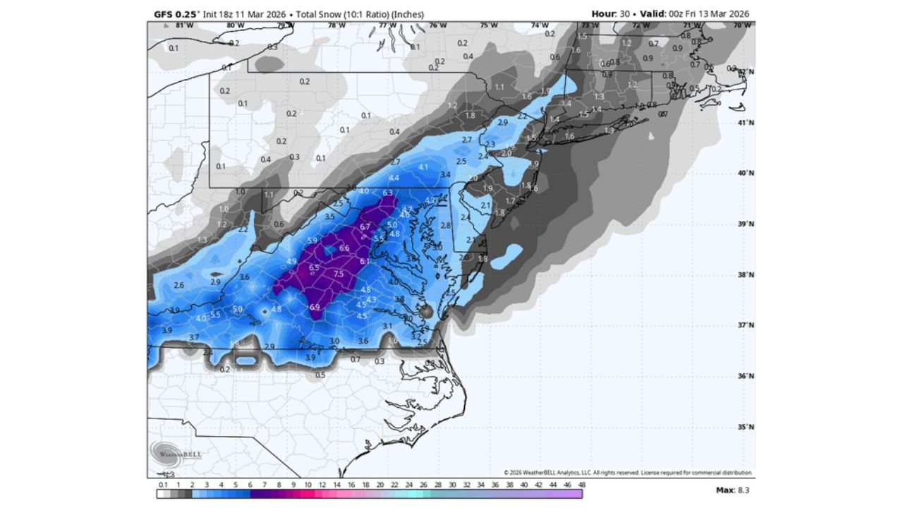
Heavy Wet Snow Projected Across the Capital Region
GFS snowfall projections show a concentrated band of accumulating snow stretching from:
- Northern Virginia
- Washington, D.C.
- Central Maryland
- Into southern Pennsylvania
Model guidance indicates:
- 3 to 5 inches common in and around D.C.
- 5 to 7 inches possible in higher elevations west of the city
- Heavier localized bands approaching 7+ inches across parts of western Maryland and northern Virginia
The snow is expected to be heavy and wet due to marginal surface temperatures near freezing.
Why This Setup Is So Rare
March snow in Washington is not unheard of, but the timing and temperature contrast make this event stand out.
A shift from 80s warmth to accumulating snow in roughly 24 hours represents an extreme atmospheric transition. Historical examples of sharp reversals exist — including notable March 1990 swings — but those occurred over several days.
This projected turnaround appears compressed into a much shorter window, intensifying the shock factor.
Potential Impacts
Heavy wet snow combined with rapidly falling temperatures may lead to:
- Slushy road conditions during peak travel
- Reduced visibility in heavier snow bands
- Tree limb stress from the weight of wet accumulation
Given the preceding warmth, road surfaces may initially resist accumulation, but heavier bursts could overcome residual heat quickly.
Watching Model Trends Closely
Confidence is increasing that a measurable snowfall event will occur, but exact totals may shift depending on:
- Surface temperature fluctuations
- Storm track adjustments
- Intensity of precipitation bands
Even modest shifts in the rain-to-snow line could significantly alter local impacts.
For residents across Washington, D.C., Maryland, and northern Virginia, this will be a remarkable example of early spring volatility — a transition from near-summer heat to accumulating snow in less than a day.
Stay with WaldronNews.com for continued updates as this rare temperature crash and snow event develops across the Mid-Atlantic.