
Washington, D.C. Records Its Most Severe Winter Since 2009–2010 as Cold and Snow Push Season Near “Extreme” Category
WASHINGTON, D.C. — The nation’s capital is experiencing its most severe winter in more than 15 years, with new data showing the 2025–2026 season ranks as the harshest since the historic 2009–2010 winter.
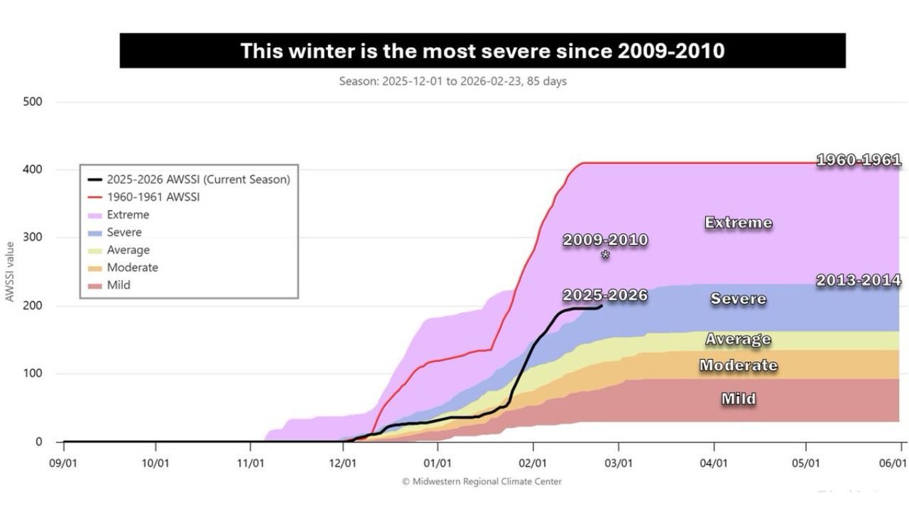
According to the Midwest Regional Climate Center’s Accumulated Winter Season Severity Index (AWSSI), this winter currently sits on the borderline between the “severe” and “extreme” categories.
The index factors in:
- How cold temperatures have been
- How much snow has fallen
- How long snow and ice have remained on the ground
Taken together, the numbers tell the story of a winter that has been persistently cold and snowy across Washington, D.C.
Every Winter Month Colder Than Normal
Each winter month so far has run colder than average in the District, with snow and ice sticking around for extended periods instead of quickly melting away.
Unlike some winters that feature brief cold snaps followed by mild rebounds, this season has been marked by consistency — steady cold and repeated snow events contributing to a steadily rising severity index.
The current AWSSI curve for 2025–2026 shows a sharp climb beginning in January and continuing through February, placing it ahead of most winters in the past decade and a half.
Highest Ranking Since 2009–2010
The only winter in recent memory that outpaces this season is 2009–2010, widely known as D.C.’s snowiest winter on record.
That season was propelled into the “extreme” category largely due to extraordinary snowfall totals. Interestingly, it was not exceptionally cold overall, but the sheer volume of snow pushed it into record territory.
This year’s winter is now tracking as the most severe since that historic benchmark.
Currently Ahead of 2013–2014
Data shows that the 2025–2026 winter is currently ranking ahead of 2013–2014, the next most severe winter over the past 15 years.
However, there remains a possibility that late-season changes could shift rankings. The winter of 2013–2014 featured a particularly cold and snowy March, which ultimately boosted its rating from severe into the extreme range.
If March remains relatively quiet this year, the current season may remain classified as severe rather than extreme.
How It Compares to the All-Time Record
While this winter has been intense, it still falls short of the most severe winter on record in Washington, D.C. — the winter of 1960–1961.
That historic season featured:
- Much colder-than-normal December, January and February
- A staggering 40.3 inches of snowfall
Compared to that benchmark, the current winter — while significant — appears somewhat less dramatic.
What This Means Going Forward
The severity ranking could still change depending on late-season weather patterns. A cold and snowy March could push the index higher, while milder conditions would likely lock this winter into the severe category.
For now, Washington, D.C. can officially claim its harshest winter in more than a decade and a half — a season defined by sustained cold, persistent snow cover and a steady climb toward historic territory.
Stay with WaldronNews.com for continued climate and seasonal outlook updates as winter transitions toward spring.