
Washington, D.C. Warms Up Next Week After Brutal Cold Blast, With Highs Back Near 40° for a Week or Longer
WASHINGTON, D.C. — If this weekend’s cold blast feels endless, the next stretch of weather offers a real mood change. Forecast messaging tied to the National Weather Service 6–10 day temperature outlook (Feb. 10–Feb. 14) suggests a warmer pattern takes over next week and likely continues beyond that, bringing Washington, D.C. back toward more manageable winter temperatures after the current surge of Arctic air.
It won’t be spring, and it won’t be a heat wave—but compared to what’s arriving for the weekend, it’s a noticeable upgrade.
The big change: highs rebound into the upper 30s and 40s
The forecast discussion in the graphic highlights a two-step pattern:
- Monday stays very cold (a final leftover punch from the Arctic blast)
- Starting Tuesday, the region trends warmer, with highs Tuesday through next weekend expected in the upper 30s to mid-40s
- Nighttime lows during that stretch are projected to settle into the 20s to near 30°F
That kind of temperature range can mean fewer “dangerous wind chill” mornings, and more afternoons where being outdoors is at least tolerable—especially if the wind relaxes compared to the weekend setup.
Still below normal, but far better than this weekend
Even with the warmer week ahead, the same note emphasizes that it’s still running below typical February standards, with normal highs described as being in the mid to upper 40s.
But here’s why it still matters: you can be “below normal” and still feel dramatically better than a weekend dominated by bitter wind chills and deep cold. This looks like that kind of improvement.
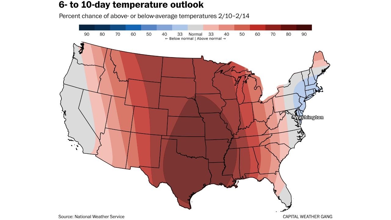
What the 6–10 day outlook is signaling
The 6–10 day outlook map (Feb. 10–Feb. 14) shows the broader pattern across the United States, and it supports the idea that the D.C. area is closer to near-normal temperatures compared to some other regions.
The note also mentions the outlook suggests:
- D.C. near normal for highs
- About normal for lows
That aligns with the idea that while the week ahead may not surge well above average, it shifts away from the extreme cold regime—especially after Monday.
D.C. could hit 40° or better for a full week (or more)
One specific callout in the forecast text is important for anyone tracking how persistent this warmup might be:
- Starting Tuesday, D.C. could reach at least 40°F for at least a week or more.
To put that in perspective, the write-up notes the last time D.C. managed highs of 40°F or higher for more than three straight days was a 12-day stretch from Jan. 4 to Jan. 15.
So the next pattern isn’t just a one-day break—it has the potential to become a more stable, consistent stretch of “normal winter cold” rather than “punishing cold.”
Early hints of an even warmer follow-up, but confidence is lower
There’s also a longer-range tease: the week after next could be even warmer, possibly pushing some highs into the 50s. However, the forecast message clearly flags that confidence is lower that far out.
In other words: the warmup next week looks like the higher-confidence part of the forecast, while any true “50s” days remain something to watch rather than count on.
What it means for residents
For people across the D.C. area, the most practical takeaway is timing:
- Prepare for the worst cold this weekend and into Monday
- Expect real relief beginning Tuesday
- Plan outdoor work, errands, and longer activities mid-to-late next week when highs trend back toward the 40s
If you’ve been waiting for a break in the brutal cold, next week appears to be the first meaningful step toward it.
What’s your forecast mood right now—just trying to survive the weekend, or already looking ahead to that 40-degree comeback? Share your local conditions and keep following updates on WaldronNews.com.