
Washington DC Maryland Virginia Residents Put On Alert Tonight as Sudden Freeze Threat Targets Entire Region
WASHINGTON DC — A region-wide freeze alert has now been issued across Washington DC, Maryland, and Virginia, with temperatures expected to plunge to freezing or below tonight into Wednesday morning, creating a widespread risk for crops, plants, and outdoor infrastructure.
This setup comes as clear skies and calming winds allow rapid nighttime cooling, setting the stage for one of the more impactful late-season cold snaps across the region.
Widespread Freeze Conditions Expected Overnight
Most of the region is expected to fall into the mid-20s to low-30s by early Wednesday morning, including:
- Washington DC
- Much of Maryland
- Northern and central Virginia
Forecast data shows:
- Upper 20s common across inland areas
- Mid-20s possible in colder rural locations
- Slightly warmer readings (near or just above freezing) closer to:
- The Potomac River
- The Chesapeake Bay
- Downtown urban areas
Even in these slightly warmer zones, temperatures may still be close enough to freezing to cause damage.
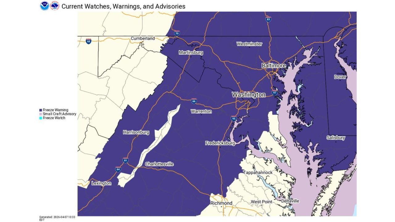
Freeze Warning Covers Nearly Entire Region
The freeze warning spans almost the entire DC metro and surrounding states, with only limited exceptions where temperatures may stay marginally higher.
This broad coverage highlights the high confidence in widespread freezing conditions, rather than isolated cold pockets.
Serious Risk to Crops and Sensitive Vegetation
This event poses a significant threat to agriculture and home gardens, especially because it arrives during the growing season.
Key risks include:
- Damage or loss of tender plants and early crops
- Harm to flowers, fruit trees, and vegetation already in bloom
- Potential issues for unprotected outdoor plumbing systems
Even a few hours below freezing can cause lasting damage, particularly for newly planted or sensitive vegetation.
Late-Season Freeze Not Uncommon But Still Impactful
While freezing temperatures in April are not unusual for this region, they can still be highly disruptive.
Typical last freeze dates show:
- Late March for Washington DC
- Early to mid-April for surrounding areas
This means the current event is arriving right in the window where many plants are most vulnerable.
Why Temperatures Are Dropping So Fast
The sharp temperature drop is being driven by:
- Clear skies, allowing heat to escape overnight
- Light winds, preventing mixing of warmer air
- A dry air mass enhancing cooling efficiency
This combination creates ideal conditions for radiational cooling, leading to rapid overnight temperature declines.
What Residents Should Do Now
With freezing temperatures expected across a wide area, residents are urged to take immediate precautions:
- Cover or bring inside plants and flowers
- Protect outdoor plumbing and irrigation systems
- Move sensitive items indoors
- Monitor local temperature updates overnight
A Critical Night for the DC Region
From Washington DC through Maryland and Virginia, tonight into Wednesday morning represents a critical freeze event that could impact both agriculture and households.
Temperatures in the 20s are expected in many areas, making this more than just a light frost.
Stay with WaldronNews.com for continued updates as conditions develop and temperatures begin to rebound later in the week.