
Washington, Montana, Iowa and Pennsylvania Lined Up for Coast-to-Coast Snow Band as Pacific Atmospheric River Meets Arctic Front
WALDRON, INDIANA – A new winter storm setup will pull Pacific Northwest moisture all the way across the country, creating a narrow but impressive band of snow from Washington state through the Upper Midwest and into Pennsylvania, New York and New England by around December 15.
Forecasters say this event will finally spread accumulating snow into some areas that have been stuck in a “snow drought,” including parts of the I-95 corridor in the Northeast.
Pacific Moisture Meets an Arctic Front
An incoming atmospheric river – a concentrated plume of Pacific moisture aimed at the Pacific Northwest – is expected to slam into the West Coast first, bringing heavy rain and mountain snow.
At the same time, an Arctic cold front will be diving south and east out of Canada. As that colder air sweeps across the northern tier of the United States, it will act like a conveyor belt, grabbing that Pacific moisture and stretching it from coast to coast.
The result is a long, fairly narrow band of snow that:
- Begins in Washington and Oregon’s higher terrain,
- Arcs across Idaho, Montana and Wyoming,
- Slides through the Dakotas, Nebraska and Iowa,
- Then continues across northern Illinois, Indiana and Ohio,
- Before finally reaching Pennsylvania, New York and much of New England.
How Much Snow Can Each Region Expect?
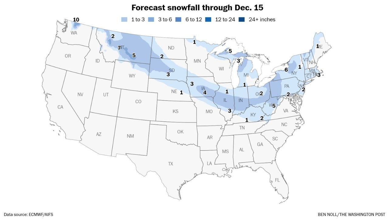
Forecast snowfall totals through December 15 show a wide range of amounts along this band:
- Pacific Northwest:
Western Washington stands out with some of the highest projected totals – around 10 inches in favored mountain areas, with several inches possible at lower elevations nearby. - Northern Rockies and High Plains:
Parts of Idaho, western Montana and Wyoming could see 5 to 7 inches, especially in higher terrain. Surrounding areas will likely see lighter, but still plowable, snow. - Northern Plains and Upper Midwest:
From South Dakota across Nebraska into Iowa, many locations are projected to pick up 3 to 4 inches, enough to coat roads and fields and create slick travel conditions.
Farther east, Wisconsin, northern Illinois and northern Indiana generally show 1 to 3 inches, with locally higher totals where snow bands set up. - Ohio Valley and Interior Northeast:
Ohio, western Pennsylvania and upstate New York are also in line for around 1 to 3 inches, with pockets of 3 to 6 inches in the higher hills.
The map highlights around 5 inches in parts of Pennsylvania and West Virginia’s higher terrain, where upslope flow can enhance snowfall. - New England and the I-95 Corridor:
Coastal Connecticut and Massachusetts show totals near 3 inches, with 1 to 3 inches possible into Rhode Island, New Hampshire and Maine.
For big cities along I-95 – from Washington, D.C., to Philadelphia, New York City and Boston – this setup may finally deliver a light but noticeable snowfall after a slow start to the season. Amounts along the immediate corridor look modest, but a coating to a couple of inches is on the table.
Overall, most communities along the band are looking at light-to-moderate snow, not a blockbuster blizzard. Still, the sheer length of the snow swath means millions of people will see at least some flakes.
Travel Impacts: Light Event, Big Footprint
Because the storm is tied to a fast-moving cold front, snow in any one location should last only several hours, not days. However, it will be falling over:
- Major cross-country routes such as I-90, I-94 and I-80 in the northern Plains and Midwest
- Key north–south corridors including I-35 and I-75
- The busy I-95 spine in the Northeast
Even 1 to 3 inches of fluffy snow can quickly coat untreated roads, especially at night or early morning. Drivers should plan for:
- Reduced visibility during heavier bursts
- Slick bridges and overpasses
- Longer travel times on Saturday night through Monday, depending on location
Air travel could also see minor delays at some northern hubs if snow bands pass over at peak times.
Why This Snow Band Matters
For many northern states, this event represents:
- A pattern change from recent dry, mild stretches to a more typical December setup
- A chance to build early-season snowpack in agricultural and watershed regions from the Northern Rockies through the Upper Midwest
- The first measurable snow of the season for parts of the Mid-Atlantic and Northeast urban corridor
At the same time, totals are not extreme enough to signal a long-term snow barrage on their own. What happens next will depend on how the jet stream behaves behind this Arctic front – whether it relaxes and allows milder Pacific air back in, or continues to send reinforcing cold shots south.
Looking Ahead
Forecasts beyond December 15 suggest that colder air will remain nearby across Canada and the northern U.S., while the southern states stay relatively mild. That means additional fast-moving systems – “clippers” – could track along the same boundary, bringing more light snow chances to the Upper Midwest, Great Lakes and Northeast later in the month.
For now, residents from Washington state to New England should prepare for a widespread but generally manageable round of snow as moisture from the Pacific atmospheric river links up with this weekend’s Arctic front.
Stay tuned to local forecasts for timing and updated amounts in your specific area, and keep checking back with WaldronNews.com as we track this coast-to-coast winter setup.