
Washington, Oregon, and Northern California Face Heavy Mountain Snow This Week as Most of the U.S. Stays Snow-Free
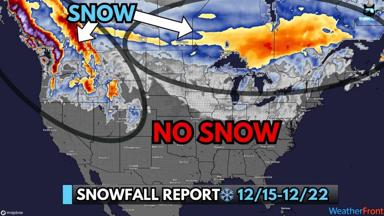
UNITED STATES — Forecast data for the December 15–22 period shows a highly uneven snowfall pattern across the country, with major impacts concentrated in the Pacific Northwest and northern California, limited snow potential in the interior Northeast, and little to no snow across most of the central and southern United States. The setup is being driven by a strong atmospheric river targeting the West Coast, while warmer air dominates much of the rest of the nation.
Pacific Northwest Is the Most Impacted Region This Week
The highest-impact snowfall zone this week is clearly the Pacific Northwest, including Washington and Oregon, where repeated waves of Pacific moisture will move inland.
According to the snowfall outlook:
“The heaviest snow will fall across the Pacific Northwest, where feet of snow could pile up over the next week.”
Mountain areas along the Cascade Range are expected to receive significant accumulations, with snowfall measured in feet rather than inches at higher elevations. This will lead to dangerous mountain travel, temporary road closures, and rapidly changing conditions on mountain passes.
Northern California’s Sierra Nevada Braces for Heavy Mountain Snow
In addition to the Pacific Northwest, northern California is also highlighted as a high-impact snowfall area, particularly across the Sierra Nevada.
The atmospheric river will push deep moisture inland, producing intense snowfall in higher elevations, while lower elevations may see rain.
Forecast guidance indicates:
“Ski resorts in the Cascades, Sierra Nevada, and parts of the Rockies are about to get absolutely slammed.”
These conditions will greatly benefit snowpack but will also increase avalanche risk and create hazardous travel conditions through mountain corridors.
Northern Rockies See Additional Snowfall Potential
Beyond the West Coast, parts of the northern Rockies will see moderate but meaningful snowfall, though totals are expected to be lower than the Cascades and Sierra Nevada.
Snow potential exists across:
- Western Montana
- Northern Idaho
- Portions of Wyoming
These areas may experience intermittent snow events, contributing to seasonal accumulation but not the extreme totals seen farther west.
Interior Northeast Has Limited but Notable Snow Chances
Outside of the western U.S., the only eastern region with meaningful snow potential this week is the interior Northeast.
Forecast data notes:
“The only other region with meaningful snow potential this week is the interior Northeast.”
This includes:
- Upstate New York
- Northern Pennsylvania
- Interior sections of New England
A couple of fast-moving systems could bring accumulating snow, though amounts will vary depending on storm track and timing.
Most of the U.S. Expected to Remain Snow-Free
The snowfall outlook clearly shows large portions of the country staying snow-free, including:
- The Southern Plains
- The Mississippi Valley
- The Southeast
- Much of the Mid-Atlantic
Warmer temperatures will trigger a broad thaw, melting existing snow cover in many areas and limiting the chance of new accumulation.
As the forecast summary explains:
“Everywhere else should stay snow free, as much warmer temperatures trigger a major thaw just in time for Christmas.”
What This Pattern Means Going Into Christmas Week
This setup creates a strong west-east contrast:
- Major winter impacts in western mountain regions
- Localized snow in the interior Northeast
- Quiet, mild conditions for most holiday travelers elsewhere
While western states manage heavy snow and mountain hazards, most of the country avoids widespread winter disruption, setting up generally favorable travel conditions ahead of Christmas.
WaldronNews.com will continue monitoring national winter weather trends. If your area is seeing heavy snowfall, travel impacts, or rapidly changing conditions, share your local update with WaldronNews.com to help keep readers informed.