
Washington, Oregon, Idaho, Montana, Minnesota, Wisconsin, Michigan, New York and Maine Could See Massive Late-Season Snowfall as Arctic Pattern Returns to Northern United States
UNITED STATES — A dramatic late-season shift in the weather pattern may bring significant winter conditions back to large parts of the northern United States, with long-range forecast guidance suggesting widespread snowfall potential from the Pacific Northwest to the Great Lakes and Northeast over the next two weeks.
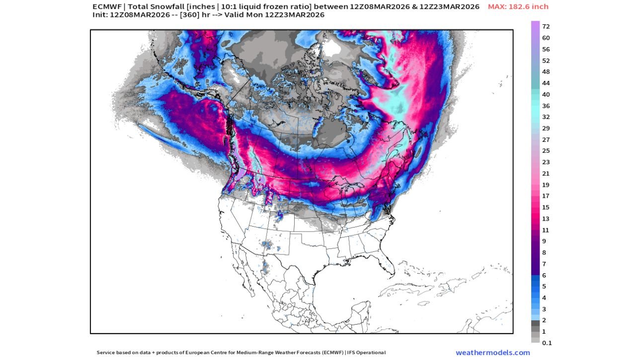
Forecast data from the ECMWF global model indicates that between March 8 and March 23, 2026, a broad corridor of colder air and repeated storm systems could generate heavy snow from Washington and Oregon through the northern Rockies, across the Upper Midwest, and into the Northeast.
The developing pattern could produce multiple rounds of snowfall, with some areas potentially seeing substantial accumulations if the storm track remains consistent across the northern tier of the country.
Pacific Northwest and Northern Rockies Could See Significant Snow
The first region highlighted for potential heavy snowfall includes the Pacific Northwest and northern Rocky Mountain region, particularly across:
- Washington
- Oregon
- Idaho
- Western Montana
Forecast projections show deep bands of snowfall across the Cascade Mountains and northern Rockies, where repeated Pacific storms interacting with colder air could lead to major mountain snow accumulation over the two-week period.
Higher elevations across these states may experience persistent snowfall events as storm systems move inland from the Pacific Ocean.
Northern Plains and Upper Midwest Could Experience Prolonged Winter Pattern
The model also indicates a strong snowfall corridor expanding eastward into the northern Plains and Upper Midwest, including:
- North Dakota
- South Dakota
- Minnesota
- Wisconsin
- Michigan
These states could see multiple winter storm systems tracking across the region, bringing several rounds of accumulating snow rather than a single event.
Parts of Minnesota, Wisconsin, and northern Michigan appear positioned within a zone where the combination of cold air and storm activity could produce notable snowfall totals over the extended period.
Great Lakes Region Could See Enhanced Snowfall
The Great Lakes region may also see enhanced snowfall potential due to the interaction between cold air and the warmer lake waters.
States likely to be affected include:
- Wisconsin
- Michigan
- Illinois
- Indiana
- Ohio
- Pennsylvania
If the colder pattern holds, lake-effect snow bands could develop across areas downwind of the lakes, producing localized heavy snowfall events during the two-week period.
Communities in northern Michigan, northern Wisconsin, and parts of western New York and Pennsylvania may be particularly vulnerable to enhanced snowfall if persistent cold air flows across the lakes.
Northeast Could See Late-Season Snowstorms
Further east, forecast projections indicate the possibility of snow extending into parts of the Northeast, including:
- New York
- Vermont
- New Hampshire
- Maine
- Massachusetts
- Pennsylvania
Storm systems tracking along the temperature boundary between colder northern air and milder southern air could produce late-season snow events during mid-March, particularly across interior areas.
Northern New England and upstate New York appear to be within the corridor where snowfall could accumulate during multiple storm systems.
Southern United States Likely to Stay Warmer
While winter conditions could intensify across the northern states, much of the southern United States is expected to remain outside the primary snow zone.
States across the Gulf Coast and Deep South may continue to experience warmer conditions, with the storm track remaining primarily across the northern half of the country.
Long-Range Forecast Still Subject to Change
Meteorologists caution that this projection is based on long-range model guidance, which can change as the forecast period approaches.
However, the current pattern strongly suggests that winter weather may remain active across the northern United States well into mid-March, with the potential for multiple snowfall events across several regions.
Stay with WaldronNews for continuing updates as meteorologists monitor this developing late-season winter pattern across Washington, Oregon, Idaho, Montana, Minnesota, Wisconsin, Michigan, and the Northeast.