
Washington Thunderstorm Drops Temperatures to Near Freezing in Anacortes as Isolated Storms Move Across Puget Sound
WASHINGTON — A brief but intense thunderstorm moved across parts of northwest Washington late Friday, producing localized heavy rain and a sharp temperature drop near Anacortes, where readings fell to 35 degrees Fahrenheit despite nearby areas seeing little to no storm activity.
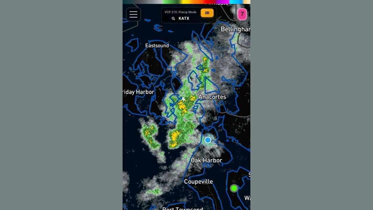
Radar imagery shows a narrow band of thunderstorms tracking across Puget Sound, brushing Anacortes, Oak Harbor, and surrounding island communities while missing nearby locations by as little as 10 miles. The storm’s isolated nature resulted in dramatic weather contrasts across short distances, with some residents experiencing a sudden cold, stormy evening while others remained dry.
Thunderstorm Brings Sudden Cold Snap to Anacortes Area
The radar data indicates a compact thunderstorm cell passing directly over or just west of Anacortes, producing moderate to locally heavy rainfall. Embedded yellow and green radar returns suggest bursts of heavier precipitation within the storm core.
As the storm passed, temperatures in Anacortes dropped rapidly to 35°F, a notable change for the area and cold enough to raise concern for slick roads, especially in low-lying and shaded areas. Nearby locations, including parts of Oak Harbor and coastal zones farther south, experienced lighter precipitation or missed the storm entirely.
Highly Localized Impacts Across Northwest Washington
The storm’s path highlights the highly localized nature of spring and early-season convective weather in western Washington. Radar imagery shows:
- Thunderstorm activity concentrated over northern Whidbey Island and adjacent waters
- Minimal impacts just a few miles away, including parts of Friday Harbor and inland areas
- Rapid temperature fluctuations tied directly to storm passage
Such sharp contrasts are common with isolated thunderstorms, especially near coastal and island terrain where airflow can rapidly change storm intensity and direction.
No Widespread Severe Weather, but Rapid Changes Noted
While the storm produced no widespread severe weather reports, the sudden temperature drop and localized heavy rain demonstrate how quickly conditions can change in the region. The lack of storm coverage elsewhere underscores how narrowly focused the event was, catching some communities off guard while others saw little impact.
Residents are reminded that even small thunderstorms can produce abrupt temperature drops, gusty winds, and reduced visibility — especially near coastal waters and island communities.
What Residents Should Watch For Next
Although this storm has moved through, similar isolated cells can develop with little notice. Residents across northwest Washington should remain alert for:
- Rapid temperature drops following showers or thunderstorms
- Brief periods of heavy rain affecting travel
- Isolated lightning strikes, even when storms appear weak on radar
Weather conditions can vary dramatically over short distances, particularly near Puget Sound and the San Juan Islands.
Stay connected with WaldronNews.com for continued updates on changing weather conditions across Washington and the Pacific Northwest.