
Weekend Rain Threat Expands From Oklahoma and Texas to Arkansas, Mississippi, Alabama, Georgia and the Carolinas With Flash Flood Risk Through Sunday
UNITED STATES — A storm system moving out of the Southwest is set to bring moderate to locally heavy rainfall across portions of the southern United States this weekend, with flash flood concerns shifting east from Oklahoma and Texas into the Deep South and Southeast by Sunday.
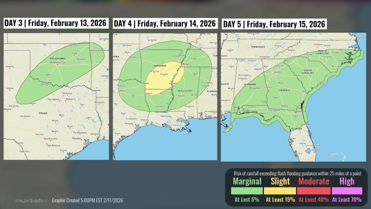
Forecast guidance for February 13–15 shows a multi-day rainfall event that will gradually track from the southern Plains into the lower Mississippi Valley before reaching the Southeast coast.
Friday: Rain Focused on Oklahoma and North Texas
On Friday, February 13, the primary rainfall corridor is centered over:
- Central and eastern Oklahoma
- Portions of north Texas
- Areas near Oklahoma City, Tulsa, and surrounding communities
A broad marginal risk zone (at least a 5% chance of flash flooding within 25 miles of a point) covers much of Oklahoma, indicating the potential for localized flooding issues where heavier downpours persist.
Urban areas and low-lying roadways in central Oklahoma may see ponding during heavier rainfall bursts.
Saturday: System Strengthens Over Arkansas, Louisiana and Mississippi
By Saturday, February 14, the rain shield expands and intensifies across:
- Arkansas
- Northern and central Louisiana
- Much of Mississippi
- Western Tennessee
- Portions of eastern Texas
A larger marginal risk area spans these states, with a more concentrated zone over parts of Arkansas and northern Mississippi suggesting an elevated potential for heavier rainfall totals.
Cities including Little Rock, Jackson, and surrounding communities may see periods of steady rain capable of producing localized flooding, especially in areas with poor drainage.
Sunday: Rain Shifts Into Alabama, Georgia and the Carolinas
On Sunday, February 15, the system pushes east into:
- Alabama
- Georgia
- South Carolina
- North Carolina
- The Florida Panhandle
- Southern portions of Tennessee
The marginal flash flood risk now covers much of the Southeast, including Atlanta, Birmingham, Charlotte, and Columbia.
While the overall risk category remains on the lower end, the broad coverage means widespread rainfall is expected, and localized heavier bands could trigger isolated flash flooding, particularly where rainfall repeats over the same locations.
Multi-Day Progression Raises Flooding Concerns
The concern with this setup is not a single intense burst of rain but rather the cumulative effect of:
- Repeated rainfall rounds
- Saturated soils from earlier precipitation
- Slow eastward movement of the system
As the system tracks from the southern Plains to the Southeast, some communities could experience multiple periods of rainfall within 48 to 72 hours.
Low-lying areas, small creeks, and urban drainage systems are most susceptible to temporary flooding.
What Residents Should Expect
Across Oklahoma, Texas, Arkansas, Louisiana, Mississippi, Alabama, Georgia, South Carolina, and North Carolina, residents should be prepared for:
- Periods of moderate to locally heavy rain
- Slower travel during heavier showers
- Temporary street flooding in poor drainage areas
- Isolated flash flooding in vulnerable locations
While this does not currently indicate a widespread high-end flood event, the gradual eastward shift of the system means impacts will extend across multiple states through the weekend.
Waldronnews.com will continue monitoring updated rainfall projections and any changes in flood risk as the system progresses from the southern Plains into the Southeast.