
Weekend Snow Threat Looms for Baltimore as Northern and Southern Jet Streams Eye Potential Phase Over the Mid-Atlantic
UNITED STATES — Another potential weekend snow threat is emerging for Baltimore and the surrounding Mid-Atlantic region as energy in both the northern and southern branches of the jet stream begins to align. While snow is far from guaranteed, forecast guidance shows the necessary ingredients starting to come together for a possible late-February storm around Sunday, February 22.
The key question now: will the two streams “phase” in time to produce a significant coastal system?
Two Branches of the Jet Stream in Play
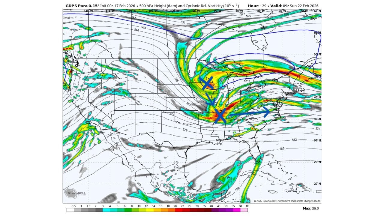
Upper-level guidance valid early Sunday morning shows:
- A strong northern-stream trough diving southeast through the Upper Midwest and Great Lakes.
- A southern-stream disturbance lifting northeast out of the Southern Plains toward the Tennessee Valley and Southeast.
These features are visible in the 500mb height and vorticity fields, where concentrated energy is positioned over:
- The Midwest
- The Lower Mississippi Valley
- The Tennessee Valley
- The Mid-Atlantic region
If these two pieces of energy merge — or “phase” — over the eastern United States, the result could be rapid cyclogenesis along or just offshore of the Mid-Atlantic coast.
Why Phasing Matters for Baltimore and the I-95 Corridor
For cities like:
- Baltimore, Maryland
- Washington, D.C.
- Philadelphia, Pennsylvania
- Wilmington, Delaware
- Possibly into southern New Jersey
The timing of that phase is critical.
If phasing occurs early enough:
- A coastal low could intensify near the Delmarva Peninsula.
- Cold air from the north could lock in.
- Snowfall would become a realistic possibility across central Maryland and the broader I-95 corridor.
If the streams fail to phase in time:
- The system may remain weaker and more progressive.
- Precipitation could shift east quickly.
- Baltimore might see minimal impact or even just rain/mixed precipitation.
At this distance, both outcomes remain on the table.
Energy Placement Suggests the Pieces Are There
The upper-air pattern shows a deepening trough carving into the eastern half of the country. Strong vorticity maxima are aligned from the Lower Mississippi Valley through the Ohio Valley and into the Mid-Atlantic.
This is often the type of configuration that precedes:
- Rapid coastal low development
- Nor’easter-type systems
- Heavy precipitation bands on the northwest side of the low
However, small differences in spacing and timing between the two jet branches can drastically change storm intensity and track.
What Needs to Happen for a Snowstorm
For a meaningful snow event in Baltimore, several conditions must align:
- Northern and southern stream energy must phase before reaching the Atlantic.
- Surface low development must occur near the Mid-Atlantic coast.
- Cold air must remain entrenched across Maryland.
- The storm track must remain close enough to produce significant precipitation, but not so far west that warmer air intrudes.
Right now, the pattern supports the possibility — but not certainty — of those ingredients aligning.
Too Early for Specific Snow Totals
At this range, snowfall projections would be speculative. High-resolution guidance will not fully resolve this system for another couple of days.
Confidence levels will improve as:
- Short-range models begin capturing the phasing process.
- Surface low placement becomes clearer.
- Thermal profiles are better defined.
For now, it is accurate to say:
Another weekend storm threat exists for Baltimore.
Snow is possible — but far from guaranteed.
What Baltimore and the Mid-Atlantic Should Do
Residents across Maryland, Washington D.C., northern Virginia, and southern Pennsylvania should:
- Monitor forecast updates through midweek.
- Avoid locking in plans based on early model runs.
- Stay aware of potential late-week shifts in track or intensity.
Late-season phasing setups can evolve quickly — sometimes strengthening dramatically within 48 hours.
WaldronNews.com will continue tracking this developing Mid-Atlantic pattern and provide updated analysis as model guidance refines the weekend storm threat.