
West Virginia Under Winter Weather Alerts as Snowstorm Targets the Region With 2–8 Inches Expected Saturday Night Into Sunday
WEST VIRGINIA — A developing winter storm is expected to bring significant snowfall across West Virginia from Saturday evening through early Sunday morning, with totals ranging from 2 to 8 inches depending on location.
Several West Virginia counties — especially in the eastern and northern portions of the state — are included in winter weather alerts as the system approaches.
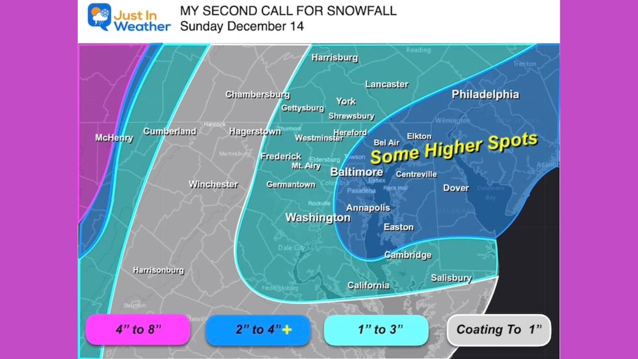
Winter Storm Warning for Western Mountain Counties: 4” to 8” of Snow
A Winter Storm Warning has been issued for parts of far western Maryland and the adjacent high terrain that borders northeastern West Virginia, including areas around:
- McHenry (MD) / Oakland area (Garrett County) — directly adjacent to WV’s highlands
- Snow impacts extending into the nearby West Virginia panhandle mountains
These high-terrain locations closest to the storm’s stronger moisture feed can expect:
- 4 to 8 inches of snow
- Heaviest accumulation late Saturday evening
- Hazardous mountain travel on routes connecting WV and western Maryland
This aligns with the magenta-highlighted region on the snowfall map.
Winter Weather Advisory for Much of Northern and Eastern West Virginia
Farther south and west, areas closer to Petersburg, Martinsburg, and the Eastern Panhandle fall under Winter Weather Advisories similar to those issued for nearby Maryland counties.
Expected snowfall:
- 1″ to 3″ for most low-elevation areas
- Isolated 4–5” totals possible in favored bands, especially closer to the Maryland border
This advisory zone includes areas highly connected to Maryland commuter routes, such as:
- Martinsburg
- Harpers Ferry
- Charles Town
- Inwood
Storm Track Brings Strong Snow Band Directly Across Northern WV
Model imagery (NAM 3 km) shows the main snow band pushing through northern West Virginia late Saturday, with continuous snowfall stretching across:
- Pittsburgh region
- Eastern Ohio
- Northern West Virginia
- Southern Pennsylvania
- Philadelphia region
For West Virginia, this means:
- The northern counties see the steadiest and longest-duration snow
- The Eastern Panhandle may sit under enhanced snowfall at times
- Southern WV sees minimal impacts
Timing: Snow Arrives Late Saturday and Peaks Overnight
Based on multiple model runs:
- Snow reaches northern WV by early evening Saturday
- Eastern Panhandle sees snow by 8–10 PM
- Heaviest snowfall occurs between 10 PM and 3 AM
- Snow tapers off near sunrise Sunday
Because temperatures will be well below freezing, accumulation will begin quickly, even on treated road surfaces.
Snowfall Expectations Across West Virginia
Northern WV & Eastern Panhandle
- 2″ to 4″ common
- Localized 4–5″ possible in stronger snow bands
- Includes Martinsburg, Berkeley County, Jefferson County
High Terrain / WV-Maryland Border Region
- 4″ to 8″, especially near Deep Creek Lake / Oakland region
- Hazardous mountain travel through the night
Central & Southern West Virginia
- Light snow or flurries
- Coating to 1″ at most
- Minimal travel impacts expected
Travel Hazards Expected Overnight
Residents should prepare for:
- Snow-covered roads
- Reduced visibility in heavier bursts
- Rapid accumulation in mountain regions
- Slick bridges and untreated secondary roads
Because the storm peaks overnight, early Sunday travel will be the most affected, especially for commuters or morning churchgoers.
First Notable Snowfall of the Season for Many West Virginians
While higher elevations of West Virginia see snow early every winter, this storm will bring the first widespread, measurable snowfall of the season for many residents of the Eastern Panhandle and northern counties.
WaldronNews.com will continue to monitor updated alerts and snowfall projections as this winter storm moves through the region.