
Western Carolinas Face Cold, Driving Rain While Georgia and Florida Brace for Severe Storm Risk Sunday With Damaging Winds Possible
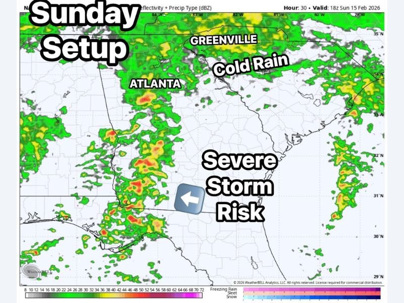
Greenville, South Carolina — A dynamic weather setup is expected to unfold across the Southeast on Sunday, bringing two very different impacts: cold, steady rain across the Western Carolinas and a growing severe storm risk farther south into Georgia and Florida. Forecasters warn that while the Carolinas deal mainly with soaking rainfall, areas south of Atlanta and into northern Florida could face stronger thunderstorms capable of producing damaging winds and isolated tornadoes.
Radar projections show widespread precipitation developing Sunday, with heavier and more unstable air shifting into southern Georgia and the Florida Panhandle, increasing the risk for severe weather.
What Happened and When
The developing system is expected to intensify Sunday as a strong disturbance moves eastward across the Deep South. By the afternoon hours, steady rainfall is forecast across Greenville, western North Carolina, and portions of the Upstate, bringing what meteorologists describe as a driving, chilly rain with periods of moderate showers.
Farther south, however, atmospheric conditions become more unstable. Cities including Atlanta, Macon, Tallahassee, and Jacksonville could see thunderstorms strengthen through the afternoon and evening as warmer, more humid air interacts with an advancing frontal boundary.
Forecast models valid Sunday evening indicate clusters of storms organizing across southern Georgia into northern Florida, where instability levels are higher compared to the cooler air mass over the Carolinas.
Severe Storm Risk in Georgia and Florida
The primary concern for Georgia and Florida will be damaging straight-line winds, particularly with any organized line of thunderstorms. Wind gusts in stronger cells could exceed 50–60 mph, capable of downing small tree limbs and causing localized power outages.
Forecasters also note that a few isolated embedded tornadoes cannot be ruled out, especially in areas where storm rotation briefly develops within the broader line. While the tornado threat does not appear widespread at this time, residents in south Georgia and northern Florida should remain weather-aware.
Communities in and around Atlanta may initially see periods of rain before stronger storms shift south and east later in the day. The most active severe window is expected Sunday afternoon through late evening.
Cold Rain Across the Western Carolinas
In contrast, the Western Carolinas, including Greenville, Asheville, and surrounding mountain communities, will experience a much colder and steadier rain. Temperatures are expected to remain cool throughout the day, limiting thunderstorm intensity but contributing to an uncomfortable, damp pattern.
While flooding does not appear widespread, persistent rainfall could create ponding on roadways and minor travel slowdowns. Gusty winds may also accompany the system, particularly along higher elevations. Residents should prepare for a raw and rainy Sunday rather than a severe weather outbreak in this portion of the region.
Safety and Preparation
Officials recommend that residents across Georgia and Florida:
- Monitor weather alerts throughout Sunday
- Secure outdoor items ahead of stronger storms
- Charge electronic devices in case of outages
- Have multiple ways to receive warnings
For those in the Carolinas, motorists should drive cautiously during periods of heavier rain and allow extra travel time.
This system highlights the sharp contrast often seen in Southeast weather setups, where cooler air north of a front brings soaking rain while warmer, unstable air to the south fuels stronger storms.
Residents are encouraged to follow WaldronNews.com for continued updates on Sunday’s storm evolution, including any issued watches or warnings as the system develops across the Southeast.