
Western High Plains Received Far Less Rain Than Expected April 8 Through 12 as Kansas, Nebraska and Oklahoma Drought Conditions Remain Unchanged
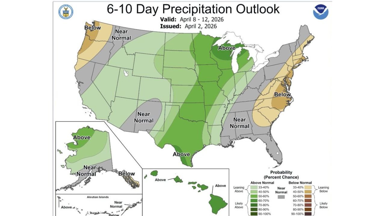
KANSAS CITY, Missouri — A significant and important weather forecasting story is emerging across the western High Plains this week — the NOAA Climate Prediction Center precipitation outlook issued on April 2, 2026 for the April 8 through 12 timeframe predicted above-normal rainfall across a broad corridor stretching from Texas through Kansas, Nebraska, Iowa, and into the Great Lakes region — but the actual precipitation that fell during that window tells a dramatically different story, particularly for farmers, ranchers, and drought-stressed communities across Kansas, Nebraska, Oklahoma, New Mexico, Wyoming, and South Dakota.
The forecast was way overdone for the western High Plains — and the farther northwest you go, the worse the bust becomes — leaving agricultural communities that were counting on meaningful rainfall to ease drought conditions still waiting for the relief that never arrived.
What NOAA Predicted vs. What Actually Fell
The April 2 NOAA Forecast: The 6-10 Day Precipitation Outlook issued April 2 showed the following expectations for the April 8-12 window:
- Above normal precipitation covering Texas, Oklahoma, Kansas, Missouri, Arkansas, Iowa, Wisconsin, Michigan, and Minnesota — shown in darker green shading with 50-80% probability of above-normal rainfall across much of this corridor
- Near normal precipitation across Nebraska, Colorado, Wyoming, New Mexico, and the broader western Plains
- A broad swath of above-normal rainfall signal stretching from the Gulf Coast through the Upper Midwest suggested meaningful precipitation was expected across the central United States
What Actually Fell — The Reality: The 5-day total precipitation analysis valid Sunday, April 12 — showing what actually fell on the ground — reveals a dramatically different picture, especially for the western and northwestern portions of the forecast area:
- Western High Plains — Kansas, Nebraska, Oklahoma, New Mexico, Wyoming, South Dakota: Rainfall totals across much of this region came in at just 0.01 to 0.20 inches — a fraction of what above-normal precipitation signals suggested. Large portions of western Kansas, western Nebraska, and the Oklahoma Panhandle received essentially nothing meaningful during the April 8-12 window
- Central Plains corridor: A narrow but intense rainfall corridor delivered 1.00 to 2.56 inches in localized areas — but this heavy rainfall was concentrated in a much tighter geographic zone than the broad above-normal forecast suggested, leaving vast areas on either side of the corridor completely dry
- Texas — Heavy but Localized: Some areas of central and southern Texas received 2.56 inches or more in localized heavy rainfall zones — but this was highly concentrated and not representative of the broad above-normal signal that covered the entire state on the NOAA forecast
- Great Lakes and Upper Midwest: Portions of Iowa, Wisconsin, and the Great Lakes corridor did receive meaningful rainfall of 0.44 to 1.58 inches in some locations — making this the region where the NOAA forecast verified most closely
Why the Western High Plains Got Shortchanged
The core problem with the April 2 NOAA forecast was the western extent of the above-normal precipitation signal — which painted a generous green blob of above-normal rainfall probability across states like Kansas, Nebraska, Wyoming, and New Mexico that ultimately received little to nothing during the forecast period.
This type of forecast bust on the western High Plains is not uncommon when large-scale precipitation outlooks are issued at 6-10 day range. The storm systems that did produce heavy rainfall during April 8-12 tracked along a narrow corridor that favored the central and southern portions of the Plains while leaving the northwestern areas almost completely dry. The farther northwest — into western Nebraska, Wyoming, and South Dakota — the more dramatically the forecast overperformed relative to what actually fell on the ground.
For farming and ranching communities across western Kansas, western Nebraska, the Oklahoma Panhandle, and eastern New Mexico who were watching the above-normal rainfall forecast with genuine hope that drought-stressed soils would finally receive meaningful relief, the actual outcome was a significant disappointment. Fields that needed an inch or more of rainfall received a tenth of an inch or less across large portions of the western High Plains.
What This Means for Drought Conditions Across the High Plains
The failure of the April 8-12 precipitation forecast to verify across the western High Plains has direct and immediate consequences for drought conditions in one of the most agriculturally critical regions in the United States:
Kansas and Nebraska: Soil moisture deficits across western Kansas and Nebraska that were already serious heading into the April 8-12 window remain largely unchanged. The storm systems that produced heavy rainfall in the central corridor largely bypassed the western portions of both states, meaning farmers in Garden City, Dodge City, Liberal, McCook, and North Platte communities are still facing the same depleted soil moisture they started the week with.
Oklahoma Panhandle and New Mexico: The extreme western reaches of the High Plains — including the Oklahoma Panhandle, eastern New Mexico, and southeastern Colorado — received virtually nothing from the April 8-12 system and continue to face some of the most severe drought conditions in the region.
Wyoming and South Dakota: The northwestern corner of the forecast bust zone — where the NOAA above-normal signal extended into Wyoming and South Dakota — also saw minimal precipitation, leaving rangeland and dryland farming operations in these states without the moisture they needed.
The Lesson — Long Range Precipitation Forecasts Have Limits
This April 8-12 forecast bust is a valuable reminder for farmers, ranchers, water managers, and anyone making decisions based on long-range precipitation outlooks — the 6-10 day probabilistic precipitation forecast is a guidance tool that indicates tendencies and probabilities, not a precise guarantee of how much rain will fall in a specific location.
When a forecast shows above-normal precipitation probability for a broad region, it means conditions are trending toward wetter than normal — not that every point within that shaded area will receive meaningful rainfall. The actual distribution of rainfall within any storm system is determined by storm tracks, moisture availability, and atmospheric dynamics that cannot be perfectly predicted 6-10 days in advance.
The western High Plains is particularly susceptible to these forecast busts because it sits at the edge of the moisture corridor — close enough to sometimes receive above-normal rainfall but often just far enough west or northwest to be missed by the heaviest precipitation zones.
What to Watch Going Forward
- Farmers and ranchers across western Kansas, western Nebraska, Oklahoma, and New Mexico should monitor shorter-range 1-3 day precipitation forecasts rather than relying heavily on 6-10 day outlooks for specific rainfall planning decisions
- The drought conditions across the western High Plains that were expected to ease during April 8-12 remain largely intact — soil moisture recovery for these communities will require additional storm systems to track more favorably in the coming weeks
- The active severe weather pattern continuing through mid-April across the central United States does carry the potential for additional rainfall opportunities — but storm track and moisture availability will again determine whether the western High Plains receives meaningful totals or gets bypassed again
- Monitor NWS local forecast offices for Kansas, Nebraska, and Oklahoma for the most accurate shorter-range precipitation guidance as new storm systems approach
The western High Plains needed rain during April 8-12 — and the forecast said it was coming. But the atmosphere had other plans, and communities from western Kansas through Wyoming and South Dakota are still waiting for the meaningful moisture relief that the long-range outlook promised but failed to deliver.
WaldronNews.com will continue tracking precipitation patterns and drought conditions across Kansas, Nebraska, Oklahoma, and the broader High Plains and will provide updates as new storm systems and rainfall opportunities develop across the region.