
Western U.S. Braces for Expanding Heat Surge as California Valley Nears Upper 80s and Desert Southwest Eyes Triple Digits, Raising Early Snowmelt Concerns
UNITED STATES — A significant warming trend is taking shape across the western United States, with new 6–10 day and 8–14 day outlooks showing strong probabilities for above-normal temperatures stretching from California through the Desert Southwest and into much of the Interior West.
Forecast guidance valid March 15–19 and again March 17–23 indicates widespread warmth intensifying across the region, with some areas seeing probabilities as high as 90–100% for above-average temperatures.
6–10 Day Outlook: Heat Builds Across California and the Southwest
During the March 15–19 period, nearly all of California, Nevada, Arizona, Utah, Oregon, Washington, and parts of Idaho and western Montana are shaded in strong above-normal categories.
The highest confidence zone — shown in the darkest shading — is centered over Southern California and the Desert Southwest, where probabilities reach the 90–100% range for above-normal temperatures.
Key impacts expected:
- California’s Central Valley could climb into the upper 80s
- Desert locations in Arizona and southeastern California may approach or exceed 100 degrees
- Interior West states including Nevada and Utah trend significantly warmer than seasonal averages
Farther east into portions of the Northern Plains and Upper Midwest, conditions transition closer to near normal before shifting below normal in parts of the Great Lakes and Northeast.
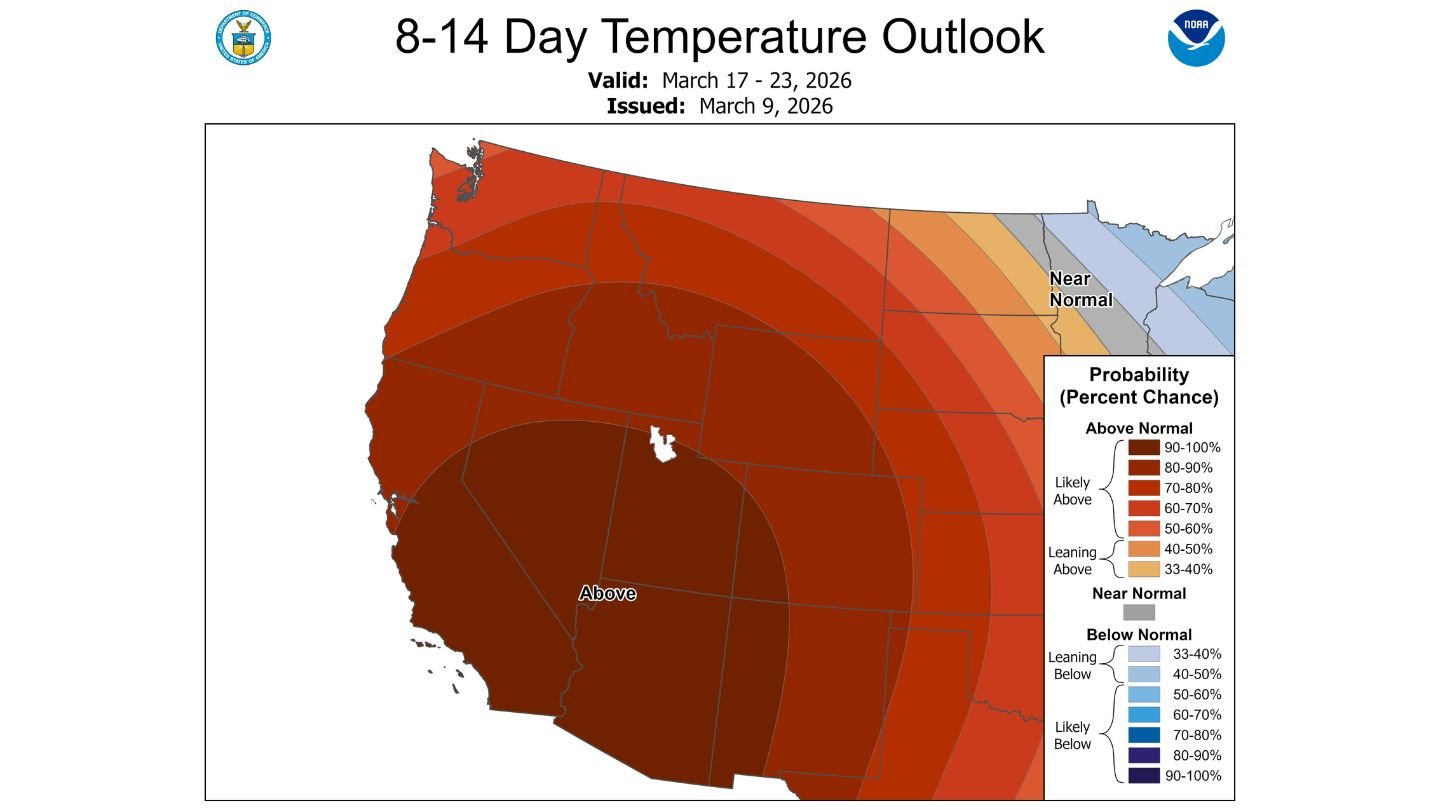
8–14 Day Outlook: Warm Pattern Expands and Persists
Looking ahead to March 17–23, the warmth not only continues but expands.
The above-normal temperature zone broadens across nearly the entire western half of the country. California, Arizona, Nevada, Utah, Oregon, Washington, and much of the Rockies remain solidly in the “likely above” category.
The core of strongest probabilities remains anchored across:
- Southern California
- Arizona
- Southern Nevada
Even areas farther north and inland remain firmly in the above-normal category, signaling a prolonged warm pattern rather than a short-lived spike.
Early High-Elevation Snowmelt Possible
One of the larger concerns tied to this developing heat surge is early-season snowmelt at higher elevations.
With mountain snowpack still present across the Sierra Nevada, Cascades, and portions of the Rockies, sustained above-normal temperatures could:
- Accelerate melting in lower and mid-elevation snow zones
- Increase early runoff into rivers and streams
- Begin shifting the seasonal water supply timeline
While widespread flooding is not indicated at this time, a prolonged stretch of unusually warm weather in mid-March can alter snowpack conditions quickly, especially if temperatures surge into the 80s and 90s at lower elevations.
A Stark Contrast Across the Nation
As the West heats up, portions of the Upper Midwest and Great Lakes show signals for below-normal temperatures during the extended period, highlighting a pronounced west-to-east temperature divide.
The most intense and persistent warmth, however, remains locked across the Southwest and California.
What to Watch Moving Forward
Residents across California and the Desert Southwest should prepare for an early taste of summer-like heat, particularly in desert communities where triple-digit temperatures are possible.
Agricultural interests, water managers, and outdoor recreation areas in higher terrain should monitor snowpack conditions closely as this warm pattern unfolds.
WaldronNews.com will continue tracking updates as this expanding western heat surge develops through mid and late March.