
Western U.S. Snowpack Falls Sharply Below Normal in Oregon, Nevada and Arizona While Wyoming and Southern California Hold Near Average
UNITED STATES — The latest snowpack data for the Western U.S. reveals a sharply divided picture as February comes to a close, with parts of Oregon, Nevada, Arizona, and New Mexico running well below normal, while Wyoming and portions of Southern California are holding closer to seasonal averages.
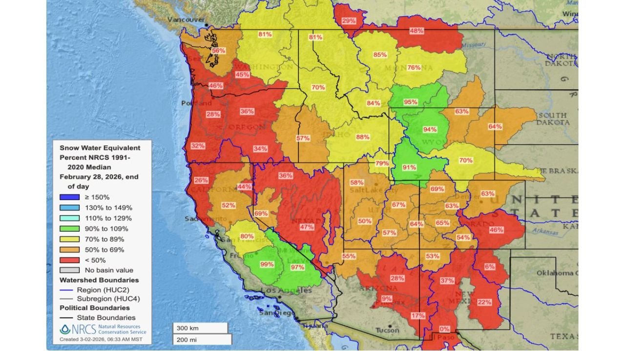
The February 28, 2026 snow water equivalent (SWE) map shows significant regional contrasts in mountain snowpack — a key factor for spring runoff, reservoir recharge, and drought outlook heading into warmer months.
Pacific Northwest Struggling
The most concerning deficits appear across:
- Western and Central Oregon: Many basins between 28% and 36% of median
- Western Washington: Around 45–56% of median
- Northern California: Several basins below 50%
Large sections of Oregon are shaded red on the map, indicating snowpack below 50% of normal — a substantial shortfall for this point in the season.
Nevada and the Desert Southwest in Deep Deficit
Conditions worsen further south:
- Nevada: Several basins around 34%–47%
- Arizona: Some areas near 28%, with extreme southern sections near 9%
- New Mexico: Widespread deficits between 17% and 37%
Parts of southern New Mexico even register near 0%, highlighting how limited snowfall has been in some high-elevation zones.
These deficits could significantly impact spring water supplies if late-season storms fail to materialize.
California Shows Sharp Contrast
California presents a split pattern:
- Northern and Central Sierra regions: Mostly 44%–52%
- Southern California mountains: Near 97%–99% of median
Southern California stands out as one of the few brighter spots, with snowpack running close to normal levels.
Rockies Mixed but More Stable
The central Rockies show more moderate conditions:
- Wyoming: Around 91%–95% of median
- Montana: Mostly 76%–85%
- Idaho: Roughly 70%–84%
- Utah: Many basins 50%–67%
Wyoming in particular remains near normal, providing some stability to regional water outlooks.
However, Utah and portions of Colorado are trending below average, which may influence reservoir inflows later this spring.
What This Means Heading Into Spring
Snowpack levels play a critical role in:
- River flows
- Agricultural irrigation
- Hydropower generation
- Wildfire risk
Regions running 30%–50% of normal face elevated drought concerns if March and April storms fail to boost totals.
Late-season snowfall is still possible, but the window for major recovery is narrowing.
Bottom Line
As of February 28:
- Oregon, Nevada, Arizona, and New Mexico are well below normal
- Utah and Colorado are below average in many basins
- Wyoming remains near normal
- Southern California is one of the strongest-performing regions
The Western snowpack picture remains uneven and fragile heading into March.
Stay with WaldronNews.com for continued updates on snowpack trends, drought conditions, and how late-season storms could reshape the water outlook for the West.