
Western U.S. Trough May Return in Mid-February, Signaling Wetter Pattern for Arkansas and the Central Plains
ARKANSAS — After weeks of a stubborn winter pattern, new medium-range forecast guidance is starting to converge on a meaningful shift in the overall weather setup across the United States — and it could have important implications for Arkansas as February moves forward.
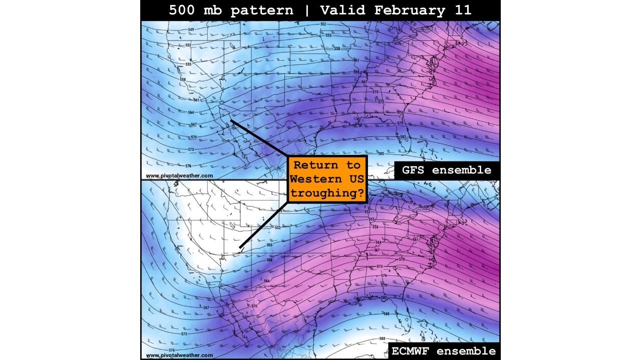
Meteorologists analyzing GFS and ECMWF ensemble data are increasingly signaling a return to western U.S. troughing during the second week of February, a pattern change that often opens the door for more active and unsettled weather across the Plains, Mississippi Valley, and portions of the South.
While confidence is still moderate due to the longer-range timeframe, the agreement between major global models is notable — and it’s something forecasters are now watching closely.
Pattern Flip Could Break the Current Stagnant Setup
For much of late January and early February, the atmosphere has been locked into a relatively stagnant configuration, limiting widespread storm activity across large parts of the country.
That may soon change.
The 500-millibar pattern forecast valid around February 11 shows growing support for a deepening trough over the western United States, with downstream ridging shifting eastward. Historically, this type of setup favors:
- Increased storm development across the central U.S.
- Stronger Pacific moisture transport into the Plains
- More frequent rain systems reaching the Mid-South and Arkansas
This does not guarantee severe weather or winter storms — but it does increase the odds of a more dynamic and active pattern compared to what residents have experienced recently.
CPC Outlook Supports Wetter Signals for the Plains
Backing up the model guidance, the latest 8–14 day precipitation outlook from the NOAA Climate Prediction Center highlights above-average precipitation probabilities across much of the Plains and Intermountain West between February 7–13.
Arkansas currently sits near the transition zone between wetter-than-normal conditions to the west and near-normal precipitation farther east — a placement that often places the state in the path of multiple passing storm systems rather than a single major event.
This positioning suggests periodic rain chances, rather than prolonged dry stretches, could become more common during mid-February.
What This Means for Arkansas
If the western trough pattern verifies, Arkansas could see:
- More frequent rain systems
- Periods of unsettled weather rather than extended calm
- Gradual erosion of recent dry spells
- Temperature swings tied to passing fronts
At this range, specific threats like severe storms, flooding, or winter weather remain unclear. Forecast confidence on hazards typically improves within 5–7 days of an event, so any talk of impacts beyond general wetness would be premature.
Still, the broader takeaway is important: the pattern is becoming more favorable for active weather, and that alone marks a shift from recent conditions.
Why Forecasters Are Paying Attention Now
Pattern changes don’t happen quietly.
When multiple global ensembles independently trend toward the same large-scale configuration, it often signals a legitimate atmospheric transition rather than a one-off model run. The fact that this signal is emerging as February begins makes it especially noteworthy, since late-winter pattern flips can dramatically alter regional weather outcomes.
For Arkansas, that means the calm, predictable stretch may soon give way to a busier and more variable mid-February outlook.
What to Watch Going Forward
Over the next several days, forecasters will be monitoring:
- Whether western troughing strengthens or weakens
- How far south storm tracks extend into the Mid-South
- Temperature profiles that could influence rain vs. wintry precipitation
- Timing of the first organized systems reaching Arkansas
Confidence will increase as February approaches, but for now, the message is simple: change may be coming.
Have you noticed unusual weather patterns where you live? Do you think Arkansas is due for a more active stretch? Share your thoughts and stay updated with WaldronNews for the latest local weather developments.